Pasco County is located on the west central coast of the U.S. state of Florida. According to the 2020 census, the population was 561,691. Its county seat is Dade City, and its largest city is Zephyrhills. The county is named after Samuel Pasco.

Brooks County is a county located in the U.S. state of Georgia, on its southern border with Florida. As of the 2020 census, the population was 16,301. The county seat is Quitman. The county was created in 1858 from portions of Lowndes and Thomas counties by an act of the Georgia General Assembly and was named for pro-slavery U.S. Representative Preston Brooks, after he severely beat abolitionist Senator Charles Sumner with a cane for delivering a speech attacking slavery.

The Suwannee River is a river that runs through south Georgia southward into Florida in the Southern United States. It is a wild blackwater river, about 246 miles (396 km) long. The Suwannee River is the site of the prehistoric Suwanee Straits that separated the Florida peninsula from the Florida panhandle and the rest of the continent.

The Apalachicola River is a river, approximately 160 miles (260 km) long, in the state of Florida. The river's large watershed, known as the Apalachicola, Chattahoochee and Flint (ACF) River Basin, drains an area of approximately 19,500 square miles (50,500 km2) into the Gulf of Mexico. The distance to its farthest head waters in northeast Georgia is approximately 500 miles (800 km). Its name comes from Apalachicola Province, an association of Native American towns located on what is now the Chattahoochee River. The Spanish included what is now called the Chattahoochee River as part of one river, calling all of it from its origins in the southern Appalachian foothills down to the Gulf of Mexico the Apalachicola.

Perdido River, historically Rio Perdido (1763), is a 65.4-mile-long (105.3 km) river in the U.S. states of Alabama and Florida; the Perdido, a designated Outstanding Florida Waters river, forms part of the boundary between the two states along nearly its entire length and drains into the Gulf of Mexico. During the early 19th century it played a central role in a series of rotating boundary changes and disputes among France, Spain, Great Britain, and the United States.

The Caloosahatchee River is a river on the southwest Gulf Coast of Florida in the United States, approximately 67 miles (108 km) long. It drains rural areas on the northern edge of the Everglades, east of Fort Myers. An important link in the Okeechobee Waterway, a manmade inland waterway system of southern Florida, the river forms a tidal estuary along most of its course and has become the subject of efforts to restore and preserve the Everglades.

The Watauga River is a large stream of western North Carolina and East Tennessee. It is 78.5 miles (126.3 km) long with its headwaters in Linville Gap to the South Fork Holston River at Boone Lake.
The Marjorie Harris Carr Cross Florida Greenway is a protected green belt corridor, more than one and a half miles (1.6 km) wide in places, that was the former route of the proposed Cross Florida Barge Canal. It is named for the leader of opposition to the Cross Florida Barge Canal, Marjorie Harris Carr, and was originally a U.S. Army Corps of Engineers canal project to connect the Gulf of Mexico and the Atlantic Ocean across Florida for barge traffic. Two sections were built, but the project was ultimately cancelled because of local opposition related to environmental concerns, including protecting the state's water supply and conservation of the Ocklawaha River Valley ecosystem, as well as national opposition for the costs being perceived as "government waste" with "limited national value." The greenway is part of the system of Florida State Parks, including the Santos Trail System, and is managed by the Florida Department of Environmental Protection.
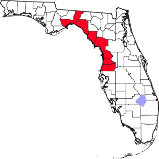
The Nature Coast is an informal, unofficial region of the U.S. state of Florida. The broadest definition of the Nature Coast includes the eight counties that abut the Gulf of Mexico along the Big Bend Coast defined by geologists: from west to east, Wakulla, Jefferson, Taylor, Dixie, Levy, Citrus, Hernando, and Pasco counties. The name "Nature Coast" was originally devised as part of a marketing campaign to promote tourism in Levy, Citrus, Hernando, and parts of Marion and Pasco counties.

Fort Cooper State Park is a 710-acre historic site in Inverness, Florida, United States. It is located two miles (3 km) south of Inverness, off of U.S. Hwy. 41 on South Old Floral City Road. On June 13, 1972, it was added to the United States National Register of Historic Places. It is also a Florida State Park.

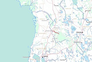
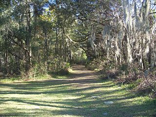
Withlacoochee State Trail is a 46-mile (74 km) long paved, multi-use, non-motorized rail trail in Florida located in Citrus, Hernando and Pasco counties. It follows along the Withlacoochee River and passes through the Withlacoochee State Forest. It is the longest paved rail trail in Florida.

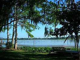
The Withlacoochee River or Crooked River is a river in central Florida, in the United States. It originates in the Green Swamp, east of Polk City, flowing west, then north, then northwest and finally west again before emptying into the Gulf of Mexico near Yankeetown. The river is 141 miles (227 km) long and has a drainage basin of 1,170 square miles (3,000 km2). It is believed to have been named after the Withlacoochee River in the northern part of the state, near the border with Georgia.

The Withlacoochee River originates in Georgia, northwest of Nashville, Georgia. It flows south through Berrien County where it joins the New River and forms part of the boundary between Berrien and Cook counties. It then flows south into Lowndes County, Georgia. At Troupville, Georgia the Little River joins the Withlacoochee River flows continues to flow south and forms part of the boundary between Lowndes and Brooks counties in Georgia. The river then flows into Florida for 1.34 miles before returning into Georgia for an additional 2.44 miles. It then returns to Florida, forming the northeast boundary of Madison County, Florida and the western boundary of Hamilton County, Florida and eventually merges with the Suwannee at Suwannee River State Park west of Live Oak. The river is 115 miles (185 km) long. It is believed to be the source for the name of the central Florida river of the same name.

Crescent Lake is a 15,960-acre (64.6 km2) freshwater lake located in Putnam and Flagler counties in North Central Florida. The lake is approximately 13 miles (21 km) in length and 2 miles (3.2 km) wide. At the north end it connects to St. Johns River by way of Dunn's Creek.

Tsala Apopka Lake is a chain of lakes located within a bend in the Withlacoochee River in Citrus County in north central Florida. This area is known historically as the Cove of the Withlacoochee.

The Little River is a 105-mile-long (169 km) tributary of the Withlacoochee River in the U.S. state of Georgia. Via the Withlacoochee and the Suwannee River its waters flow to the Gulf of Mexico. The Little River was also known historically as the Ockolocoochee River.
Greater Tampa Bay Area Council serves Scouts in West-Central Florida with the council headquarters in Tampa, Florida. Youth are served in the following nine counties: Citrus, Hardee, Hernando, Highlands, Hillsborough, Pasco, Pinellas, Polk and Sumter. Greater Tampa Bay Area Council was formed on May 1, 2016 by the merger of Gulf Ridge Council with West Central Florida Council.