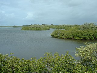
The Saint Sebastian River [1] is a river in the U.S. state of Florida, a tributary of the Indian River west and north of the city of Sebastian.
Contents


The Saint Sebastian River [1] is a river in the U.S. state of Florida, a tributary of the Indian River west and north of the city of Sebastian.
Dredging took place from 2006 through 2009, costing $18 million and removing 2,000,000 cubic feet (57,000 m3) of muck from the bottom of the St. Sebastian River. The muck consisted of silt, clay, sand, shell and organic material, which consumed oxygen and threatened the life of aquatic species. [2]

Indian River County is a county located in the southeastern and east-central portions of the U.S. state of Florida. As of the 2020 census, the population was 159,788. Its seat is Vero Beach. It is Florida's 7th richest county and in 2000 was the 87th richest county in the U.S. by per capita income.

St. Lucie County is a county located in the southeastern portion of the U.S. state of Florida. As of the 2020 census, the population was 329,226. The county's seat is Fort Pierce. St. Lucie County is included in the Port St. Lucie, FL Metropolitan Statistical Area.
Windsor, formerly known as North Beach, is a gated community and census-designated place (CDP) on North Hutchinson Island in Indian River County, Florida, United States. The population was 256 at the 2010 census. It is part of the Sebastian–Vero Beach Metropolitan Statistical Area.

Roseland is an unincorporated community and census-designated place (CDP) in Indian River County, Florida, United States. The population was 1,472 at the 2010 census, down from 1,775 at the 2000 census. It is part of the Sebastian–Vero Beach Metropolitan Statistical Area.

Sebastian is a city in Indian River County, Florida, United States at the confluence of the St. Sebastian River and the Indian River. It is two miles away from the Atlantic Ocean. It is the largest city in Indian River County and the biggest population center between Palm Bay, Florida and Fort Pierce, Florida. The city’s economy is heavily reliant on tourism. It has numerous resorts in the local area, such as Disney's Vero Beach Resort. It is very close to many natural and scenic areas like the Pelican Island National Wildlife Refuge, Sebastian Inlet State Park, and St. Sebastian River Preserve State Park.

Indian River Shores is a resort town on Orchid Island, in Indian River County, Florida, United States. Surrounded by water, the town is bordered by the Indian River to the west and the Atlantic Ocean to the east. The population was 3,901 at the 2010 census, up from 3,448 at the 2000 census. It was ranked ninth in Florida locations by per capita income as of 2010. The town's wealth has given it the reputation of a exclusive tourist town.
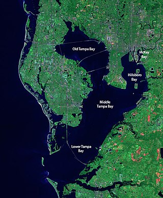
Tampa Bay is a large natural harbor and shallow estuary connected to the Gulf of Mexico on the west-central coast of Florida, comprising Hillsborough Bay, McKay Bay, Old Tampa Bay, Middle Tampa Bay, and Lower Tampa Bay. The largest freshwater inflow into the bay is the Hillsborough River, which flows into Hillsborough Bay in downtown Tampa. Many other smaller rivers and streams also flow into Tampa Bay, resulting in a large watershed area.

The Miami River is a river in the United States state of Florida that drains out of the Everglades and runs through the city of Miami, including Downtown. The 5.5-mile (8.9 km) long river flows from the terminus of the Miami Canal at Miami International Airport to Biscayne Bay. It was originally a natural river inhabited at its mouth by the Tequesta Indians, but it was dredged and is now polluted throughout its route through Miami-Dade County. The mouth of the river is home to the Port of Miami and many other businesses whose pressure to maintain it has helped to improve the river's condition.

Sebastian Inlet, located in Sebastian Inlet State Park in Brevard County, Florida and Indian River County, Florida, offers surfing and fishing opportunities. It is off State Road A1A just 12 miles north of Vero Beach. There are annual surf tournaments, professional and amateur. Visitors fish there, particularly for Snook and Redfish.

Hamilton Disston was an industrialist and real-estate developer who purchased 4 million acres (16,000 km²) of Florida land in 1881, an area larger than the state of Connecticut, and reportedly the most land ever purchased by a single person in world history. Disston was the son of Pennsylvania-based industrialist Henry Disston who formed Disston & Sons Saw Works, which Hamilton later ran and which was one of the largest saw manufacturing companies in the world.

The Indian River Lagoon is a grouping of three lagoons: the Mosquito Lagoon, the Banana River, and the Indian River, on the Atlantic Coast of Florida; one of the most biodiverse estuaries in the Northern Hemisphere and is home to more than 4,300 species of plants and animals.

The St. Lucie Inlet, Florida is located between Hutchinson Island and Jupiter Island in Martin County, Florida, at coordinates 27°09′58″N80°09′24″W. The St. Lucie Inlet is one of six inlets into the Indian River Lagoon.
The Nanticoke River is a tributary of the Chesapeake Bay on the Delmarva Peninsula. It rises in southern Kent County, Delaware, flows through Sussex County, Delaware, and forms the boundary between Dorchester County, Maryland and Wicomico County, Maryland. The tidal river course proceeds southwest into the Tangier Sound, Chesapeake Bay. The river is 64.3 miles (103.5 km) long. A 26-mile ecotourism water trail running along the River was set aside in July 2011 by Delaware state and federal officials, contiguous with a 37-mile water-trail extending through Maryland to the Chesapeake Bay.

Barefoot Bay is an unincorporated, deed-restricted manufactured home community, recreation district, and water and sewer district in southern Brevard County, Florida. The population at the 2010 United States Census was 9,808.
The Oleta River, situated north of Miami, drains the northern Everglades into Biscayne Bay, allowing freshwater to reach the Atlantic Ocean. Today, it is the only natural river in Miami-Dade County that has not been dredged and channelized. Its seven miles (11 km) of shoreline are largely undeveloped, making the Oleta River Corridor a vestige of wilderness in a matrix of urbanization.

The St. Lucie River is a 35-mile-long (56 km) estuary linked to a coastal river system in St. Lucie and Martin counties in the Florida, United States. The St. Lucie River and St. Lucie Estuary are an "ecological jewel" of the Treasure Coast, central to the health and well-being of the surrounding communities. The river is part of the larger Indian River Lagoon system, the most diverse estuarine environment in North America with more than 4,000 plant and animal species, including manatees, oysters, dolphins, sea turtles and seahorses.
Eau Gallie River is a 3.9-mile-long (6.3 km) river in Eau Gallie, Florida, United States. It is a tributary of the Indian River, with its mouth near Hawthorne Point.
Okeelanta is an unincorporated community in Palm Beach County, Florida, United States, located approximately 4 miles (7 km) south of South Bay on U.S. Route 27 at County Road 827. It was originally developed as a planned community in the 1910s, but had effectively disappeared by the end of the 1920s. The name is a portmanteau of Lake Okeechobee and Atlantic Ocean.

The Snapper Creek is a creek in the U.S. state of Florida that drains out of the Everglades into Biscayne Bay at Biscayne National Park. It is a 4-mile (6.4 km) long creek 15 miles (24 km) south of Downtown Miami, running through the suburbs of Kendall and Coral Gables in metropolitan Miami. The creek extends from Biscayne Bay inland to the Snapper Creek Canal, which extends 10 miles (16 km) further to the Everglades.
Coordinates: 27°51′17″N80°29′26″W / 27.8547468°N 80.4906081°W