
Geologists from the Florida Department of Environmental Protection claim that the U.S. state of Florida may have the largest convergence of freshwater springs on the planet, with over 700. [1] Hydrological springs are naturally occurring places where water flows from the aquifer (underground) to the surface. There are springs located within 21 Florida State Parks.
Contents
In the 1800s, the crystal clear water attracted development; 14 Florida cities have "Spring" in their name. [2] Spring names have been duplicated in different parts of the state, such as Gator [3] and Salt; Blue Spring was so common that the county name was added to differentiate between the seven locations. [4] [5]
The first comprehensive study of Florida's springs was published in 1947. The next update was released 30 years later in the Florida Geological Survey Bulletin No. 31, Revised, "Springs of Florida". [6] In the 1977 Rosenau survey, there were sixteen offshore (under water) springs identified. All but two were situated on the Gulf coast. Since that time, scores of additional springs have been located and are being studied. [7] The most recent compendium of spring data is contained in the 2004 publication, Florida Geological Survey Bulletin 66, and identified 720 springs, of which 33 were first magnitude, 191 were second magnitude, and 151 were third magnitude. [7] Springs are identified by type: river rise (RR) is where a river emerges after flowing underground for a distance; a single spring (SS) has one underground source, but may flow through multiple rock fissures; a group spring (GS) has multiple underground sources; a sink (SK) is an opening in the Earth's surface that occurs from karst processes [8] and/or suffosion. [9]
Volume values listed are the most recent found, mostly after 2000, but water outflows have diminished significantly since the 1990s with drought conditions and increased pumping from the Floridan aquifer. [10] Water flow diminished and stopped completely at several locations, including White Springs and Worthington Springs, where tourists flocked to drink and soak in the mineral water beginning in the late 1800s. [1] [11] The public water plant at Boulware Springs provided water for the city of Gainesville, Florida and the University of Florida until 1913, when reduced outflow required a new water source. [12] [13]
Many of the springs listed herein are indicated as privately owned, which is a misnomer. "Private individuals cannot 'own' a spring that is along/accessible from a navigable waterway . They own the land around it above the normal high water mark." [14] Since the 1972 Clean Water Act (CWA) defined the term "navigable waters", the meaning has been litigated. Following U.S. Supreme Court rulings, the Federal Register published EPA's final definition on November 26, 2008. Section (3) states: "intrastate lakes, rivers, and streams which are utilized by interstate travelers for recreational or other purposes (are navigable waters). [15] Courts have ruled that "shallow streams that are traversable only by canoe have met the test". [16]
Note: The table of contents only applies when the list is sorted by spring name.
|
|
|
| Mag [7] | Spring name | Outflow body [7] | Type [7] | County [7] | Daily flow in millions [7] | Temp [7] | Own [7] | Photo |
|---|---|---|---|---|---|---|---|---|
| 1st | Alapaha Rise # | Alapaha River | RR | Hamilton | 383.9 US gallons (1,453 L) | 70.3 °F (21.3 °C) | P |  |
| 1st | Alexander ‡ | St. Johns River | SS | Lake | 60.9 US gallons (231 L) | 74.5 °F (23.6 °C) | F ↑ |  |
| 2nd | Apopka # | Lake Apopka | SS | Lake | 16.0 US gallons (61 L) | 75.5 °F (24.2 °C) | P ↑ |  |
| 2nd | Aucilla (Wacissa) | Wacissa River | GS | Jefferson | 189.4 US gallons (717 L) § | 68.9 °F (20.5 °C) | P ↑ | |
| 2nd | Baltzell | Chipola River | GS | Jackson | 31.5 US gallons (119 L) | 67.7 °F (19.8 °C) | S/C |  |
| 2nd | Beecher # | St. Johns River | SS | Putnam | 5.8 US gallons (22 L) | 73.1 °F (22.8 °C) | S |  |
| 1st | Big Blue (Wacissa) | Wacissa River | GS | Jefferson | 189.4 US gallons (717 L) § | 68.9 °F (20.5 °C) | P ↑ |  |
| 1st | Blue † | St. Johns River | SS | Volusia | 102.0 US gallons (386 L) | 73.0 °F (22.8 °C) | S ↑ |  |
| 3rd | Blue (Levy County) | Waccasassa River | SS | Levy | 4.42 US gallons (16.7 L) [17] | 70.9 °F (21.6 °C) | C | |
| 1st | Blue Grotto (Silver) † | Silver River | GS | Marion | 359.3 US gallons (1,360 L) § | 74.3 °F (23.5 °C) | P | |
| 2nd | Blue Hole (Florida Caverns State Park) † | Chipola River | SS | Jackson | 12.71 US gallons (48.1 L) [18] | 67.80 °F (19.89 °C) | S |  |
| 1st | Blue Hole (Ichetucknee) † | Ichetucknee River | GS | Columbia | 130.2 US gallons (493 L) § | 71.4 °F (21.9 °C) | S ↑ |  |
| 4th | Boulware | Paynes Prairie [19] | SS | Alachua | 0.2 US gallons (0.76 L) [12] | 72.0 °F (22.2 °C) [12] | C |  |
| 2nd | Branford | Suwannee River | SS | Suwannee | 4.3 US gallons (16 L) | 69.5 °F (20.8 °C) | C |  |
| 2nd | Buckhorn Main # | Alafia River | GS | Hillsborough | 9.7 US gallons (37 L) | 76.5 °F (24.7 °C) | P |  |
| 2nd | Bugg # | Lake Denham | SS | Lake | 5.5 US gallons (21 L) | 74.2 °F (23.4 °C) | P |  |
| 1st | Cedar Head (Ichetucknee) † | Ichetucknee River | GS | Columbia | 130.2 US gallons (493 L) § | 71.4 °F (21.9 °C) | S | |
| 1st | Chassahowitzka | Chassahowitzka River | GS | Citrus | 34.3 US gallons (130 L) | 73.4 °F (23.0 °C) | S ↑ |  |
| 2nd | Citrus Blue | Withlacoochee River | SS | Citrus | 10.5 US gallons (40 L) | 72.8 °F (22.7 °C) | P ↑ |  |
| 2nd | Columbia # | Santa Fe River | SS | Columbia | 25.5 US gallons (97 L) | 72.3 °F (22.4 °C) | P |  |
| 2nd | Copper | Suwannee River | GS | Dixie | 8.8 US gallons (33 L) | 71.1 °F (21.7 °C) | P |  |
| NA | Cow # | Suwannee River | SK | Lafayette | NA | 71.8 °F (22.1 °C) | P ↑ |  |
| 2nd | Crystal Springs # | Hillsborough River | SS | Pasco | 30.0 US gallons (114 L) [20] | 72 °F (22 °C) | P |  |
| 1st | Cypress # | Holmes Creek Choctawhatchee River | SS | Washington | 65.3 US gallons (247 L) | 67.7 °F (19.8 °C) | P |  |
| 2nd | De Leon † | Spring Garden Creek St. Johns River | SS | Volusia | 17.6 US gallons (67 L) | 73.3 °F (22.9 °C) | S ↑ |  |
| NA | Devil's Den | None | SK | Levy | NA | 72.0 °F (22.2 °C) | P ↑ |  |
| 2nd | Devil's Ear/Eye/Little | Santa Fe River | GS | Gilchrist | 17.8 US gallons (67 L) | 72.6 °F (22.6 °C) | P ↑ |  |
| 1st | Emerald (Gainer #2) | Econfina Creek | GS | Bay | 124.6 US gallons (472 L) § | 70.5 °F (21.4 °C) | P ↑ |  |
| 2nd | Ellaville | Suwannee River | SS | Suwannee | 26.3 US gallons (100 L) | 73.2 °F (22.9 °C) | P ↑ |  |
| 1st | Falmouth | Karst fenster | SS | Suwannee | 102.8 US gallons (389 L) | 69.3 °F (20.7 °C) | S |  |
| 1st | Fanning † | Suwannee River | SS | Levy | 33.3 US gallons (126 L) | 72.9 °F (22.7 °C) | P |  |
| 2nd | Fenney # | Shady Brook Lake Panasoffkee | SS | Sumter | 9.0 US gallons (34 L) | 73.6 °F (23.1 °C) | P |  |
| 2nd | Fern Hammock ‡ | Juniper Creek Lake George | GS | Marion | 6.9 US gallons (26 L) | 71.7 °F (22.1 °C) | F |  |
| 1st | Gainer #3 | Econfina Creek | GS | Bay | 124.6 US gallons (472 L) § | 70.9 °F (21.6 °C) | P/S ↑ |  |
| 4th | Gator # | Hammock Creek | SS | Hernando | 0.2 US gallons (0.76 L) | 65.5 °F (18.6 °C) | P ↑ |  |
| 2nd | Gilchrist Blue | Santa Fe River | GS | Gilchrist | 6.9 US gallons (26 L) | 72.8 °F (22.7 °C) | P ↑ |  |
| 2nd | Gemini Springs | Lake Monroe | GS | Volusia | 6.5 US gallons (25 L) | 72 °F (22 °C) | C |  |
| 2nd | Ginnie | Santa Fe River | GS | Gilchrist | 37.6 US gallons (142 L) | 72.5 °F (22.5 °C) | P ↑ |  |
| 4th | Glen | Hogtown Creek | SS | Alachua | 0.1 US gallons (0.38 L) | 71.8 °F (22.1 °C) | P |  |
| 3rd | Green Cove | St. Johns River | SS | Clay | 1.8 US gallons (6.8 L) | 75.9 °F (24.4 °C) | C |  |
| 3rd | Green Springs | Lake Monroe | SS | Volusia | 5.98 US gallons (22.6 L) | 72 °F (22 °C) | C |  |
| 2nd | Guaranto | Suwannee River | SS | Dixie | 6.0 US gallons (23 L) | 73.0 °F (22.8 °C) | C |  |
| 2nd | Hardee | Withlacoochee River | SS | Hamilton | 17.5 US gallons (66 L) [21] | 76.6 °F (24.8 °C) | S | |
| 2nd | Hart | Suwannee River | GS | Gilchrist | 26.7 US gallons (101 L) | 71.9 °F (22.2 °C) | C ↑ |  |
| 2nd | Hernando Salt # | Mud River | SS | Hernando | 21.3 US gallons (81 L) | 74.9 °F (23.8 °C) | P ↑ |  |
| 1st | Holton Creek Rise # | Suwannee River | RR | Hamilton | 157 US gallons (590 L) [22] | 71.8 °F (22.1 °C) | S |  |
| 1st | Homosassa † | Homosassa River | GS | Citrus | 56.2 US gallons (213 L) | 74.3 °F (23.5 °C) | S |  |
| 2nd | Hornsby # | Santa Fe River | SS | Alachua | 32.9 US gallons (125 L) [10] | 72.5 °F (22.5 °C) [10] | P ↑ |  |
| 2nd | Hunter (Kings Bay) | Crystal River | GS | Citrus | 630.2 US gallons (2,386 L) § | 73.4 °F (23.0 °C) | C/P |  |
| 1st | Ichetucknee † | Ichetucknee River | GS | Columbia | 130.2 US gallons (493 L) § | 71.5 °F (21.9 °C) | S |  |
| 1st | Jackson Blue | Merritt's Millpond Chipola River | GS | Jackson | 41.1 US gallons (156 L) | 69.7 °F (20.9 °C) | S/C |  |
| 2nd | Juniper ‡ | Juniper Creek Lake George | GS | Marion | 5.3 US gallons (20 L) | 71.6 °F (22.0 °C) | F |  |
| 1st | Kings Bay | Crystal River | GS | Citrus | 630.2 US gallons (2,386 L) § | 73.2 °F (22.9 °C) | S/P | |
| 1st | Kini/Upper River Sink | Karst fenster | SK | Wakulla | 113.8 US gallons (431 L) [6] | 69.8 °F (21.0 °C) [6] | P |  |
| Zero | Kissingen | Peace River | GS | Polk | 0.0 US gallons (0 L) [6] | 72.0 °F (22.2 °C) [23] | P |  |
| 1st | Lafayette Blue † | Suwannee River | SS | Lafayette | 29.7 US gallons (112 L) | 71.1 °F (21.7 °C) | S ↑ |  |
| 4th | Levy Blue # | Waccasassa River | SS | Levy | 1.1 US gallons (4.2 L) | 69.8 °F (21.0 °C) | C |  |
| 1st | Lime Sink Run † | Suwannee River | SS | Suwannee | 111.8 US gallons (423 L) [14] | 72.2 °F (22.3 °C) | S |  |
| 2nd | Lithia Major, Minor | Alafia River | GS | Hillsborough | 19.7 US gallons (75 L) | 77.2 °F (25.1 °C) | C |  |
| 3rd | Little # | Weeki Wachee River | SS | Hernando | 3.4 US gallons (13 L) | 74.6 °F (23.7 °C) | P ↑ |  |
| 2nd | Little River | Suwannee River | SS | Suwannee | 54.9 US gallons (208 L) | 72.1 °F (22.3 °C) | S ↑ |  |
| 1st | Madison Blue † | Withlacoochee River | SS | Madison | 46.1 US gallons (175 L) | 70.3 °F (21.3 °C) | S/C ↑ |  |
| 4th | Magnolia # | Hammock Creek | SS | Hernando | 0.3 US gallons (1.1 L) | 74.3 °F (23.5 °C) | P |  |
| 2nd | Manatee † | Suwannee River | SS | Levy | 99.5 US gallons (377 L) | 72.5 °F (22.5 °C) | S ↑ |  |
| 1st | McCormick (Gainer #1) | Econfina Creek | GS | Bay | 124.6 US gallons (472 L) § | 70.8 °F (21.6 °C) | P ↑ |  |
| 1st | Morrison | Choctawhatchee River | SS | Walton | 40.6 US gallons (154 L) | 67.8 °F (19.9 °C) | S/C ↑ |  |
| 1st | Natural Bridge † | Karst fenster St. Marks River | SS | Leon | 98.2 US gallons (372 L) | 68.1 °F (20.1 °C) | P |  |
| 1st | Nutall Rise | Aucilla River | RR | Jefferson | 232.7 US gallons (881 L) | 70.3 °F (21.3 °C) | P |  |
| 3rd | Orange # | Orange Creek Oklawaha River | GS | Marion | 1.9 US gallons (7.2 L) | 74.0 °F (23.3 °C) | P |  |
| 2nd | Otter | Suwannee River | SS | Gilchrist | 3.1 US gallons (12 L) | 72.7 °F (22.6 °C) | P |  |
| NA | Paradise [24] | None | SK | Marion | NA | 73.0 °F (22.8 °C) | P ↑ | |
| 3rd | Peacock † | Suwannee River | GS | Suwannee | 5.7 US gallons (22 L) | 69.5 °F (20.8 °C) | S ↑ |  |
| 2nd | Pitt | Econfina Creek | GS | Walton | 3.6 US gallons (14 L) [6] | 71.6 °F (22.0 °C) [6] | C |  |
| 2nd | Poe | Santa Fe River | SS | Alachua | 3.9 US gallons (15 L) | 72.5 °F (22.5 °C) | C |  |
| 2nd | Ponce de Leon † | Sandy Creek Choctawhatchee River | GS | Holmes | 5.7 US gallons (22 L) | 67.8 °F (19.9 °C) | S |  |
| 1st | Rainbow † | Rainbow River Withlacoochee River | GS | Marion | 409.8 US gallons (1,551 L) | 74.1 °F (23.4 °C) | S/P |  |
| 1st | Roaring (Ichetucknee) † | Ichetucknee River | GS | Columbia | 130.2 US gallons (493 L) § | 70.0 °F (21.1 °C) | S | |
| 2nd | Rock | Rock Springs Run Wekiva River | SS | Orange | 30.0 US gallons (114 L) | 74.9 °F (23.8 °C) | C |  |
| 2nd | Rock Bluff | Suwannee River | GS | Gilchrist | 17.9 US gallons (68 L) | 71.6 °F (22.0 °C) | P ↑ |  |
| Zero | Rossetter | Withlacoochee River | SS | Hamilton | 0.0 US gallons (0 L) | 76.6 °F (24.8 °C) | S |  |
| 3rd | Royal | Suwannee River | SS | Suwannee | 1.6 US gallons (6.1 L) [10] | 72.7 °F (22.6 °C) [10] | C |  |
| 2nd | Running East, West # | Suwannee River | GS | Lafayette Suwannee | 18.2 US gallons (69 L) | 71.8 °F (22.1 °C) | P ↑ |  |
| 2nd | Salt (Marion) ‡ | Lake George | SS | Marion | 49.4 US gallons (187 L) | 74.5 °F (23.6 °C) | F |  |
| 2nd | Sanlando # | Wekiva River | SS | Seminole | 8.5 US gallons (32 L) | 76.4 °F (24.7 °C) | P |  |
| 2nd | Santa Fe # | Santa Fe River | SS | Columbia | 81.4 US gallons (308 L) [10] | 73.0 °F (22.8 °C) [10] | P ↑ |  |
| 2nd | Santa Fe Rise † | Santa Fe River | RR | Alachua | 48.5 US gallons (184 L) | 72.5 °F (22.5 °C) | S ↑ |  |
| 2nd | Shangri La # | Merritt's Millpond Chipola River | SS | Jackson | 2.5 US gallons (9.5 L) [3] | 69.7 °F (20.9 °C) | P ↑ |  |
| 1st | Silver † | Silver River Oklawaha River | GS | Marion | 359.3 US gallons (1,360 L) § | 73.8 °F (23.2 °C) | S |  |
| 1st | Silver Glen ‡ | St. Johns River | GS | Marion | 70.5 US gallons (267 L) | 74.1 °F (23.4 °C) | F |  |
| 1st | Siphon Creek Rise # | Santa Fe River | RR | Gilchrist | 77.6 US gallons (294 L) | 72.4 °F (22.4 °C) | S |  |
| 1st | Spring Creek | Apalachee Bay | SS | Wakulla | 198.4 US gallons (751 L) | 70.9 °F (21.6 °C) | S/P |  |
| 1st | St. Marks Rise # | St. Marks River | RR | Leon | 292.1 US gallons (1,106 L) | 68.8 °F (20.4 °C) | P |  |
| 2nd | Starbuck # | Wekiva River | SS | Seminole | 9.4 US gallons (36 L) | 76.1 °F (24.5 °C) | P |  |
| 1st | Steinhatchee Rise | Steinhatchee River | RR | Taylor Dixie | 226.2 US gallons (856 L) | 70.0 °F (21.1 °C) | S |  |
| 2nd | Sun | Suwannee River | SS | Gilchrist | 4.5 US gallons (17 L) | 72.7 °F (22.6 °C) | P |  |
| 2nd | Suwanacoochee | Withlacoochee River | SS | Suwannee | 0.3 US gallons (1.1 L) | 69.9 °F (21.1 °C) | S ↑ |  |
| 2nd | Suwannee | Suwannee River | GS | Suwannee | 9.1 US gallons (34 L) | 72.5 °F (22.5 °C) | S |  |
| 2nd | Suwannee Blue # | Suwannee River | SS | Suwannee | 8.6 US gallons (33 L) | 70.9 °F (21.6 °C) | P |  |
| 1st | Tarpon Hole (Kings Bay) | Crystal River | GS | Citrus | 630.2 US gallons (2,386 L) § | 73.2 °F (22.9 °C) | C/P |  |
| 2nd | Telford | Suwannee River | SS | Suwannee | 20.1 US gallons (76 L) | 70.2 °F (21.2 °C) | P |  |
| 2nd | Three Sisters (Kings Bay) | Crystal River | GS | Citrus | 630.2 US gallons (2,386 L) § | 73.3 °F (22.9 °C) | P |  |
| 1st | Treehouse # | Santa Fe River | SS | Alachua | 25.8 US gallons (98 L) | 71.4 °F (21.9 °C) | P |  |
| 1st | Troy † | Suwannee River | SS | Lafayette | 98.2 US gallons (372 L) [22] | 71.0 °F (21.7 °C) | S ↑ |  |
| 2nd | Volusia Blue † | St. Johns River | SS | Volusia | 56.2 US gallons (213 L) | 73.6 °F (23.1 °C) | S ↑ |  |
| 2nd | Vortex | Blue/Sandy Creek Choctawhatchee River | SS | Holmes | 4.5 US gallons (17 L) | 71.6 °F (22.0 °C) [6] | P ↑ |  |
| 2nd | Wacissa Group | Wacissa River | GS | Jefferson | 189.4 US gallons (717 L) § | 68.90 °F (20.50 °C) | S/P |  |
| 1st | Wakulla † | Wakulla River | SS | Wakulla | 252.02 US gallons (954.0 L) | 70.2 °F (21.2 °C) | S |  |
| 3rd | Waldo # | Fenholloway River | SS | Taylor | 0.7 US gallons (2.6 L) | 74.5 °F (23.6 °C) | P |  |
| 3rd | Wall [25] | Boggy Bayou | SS | Pinellas | 4.2 US gallons (16 L) | 74.0 °F (23.3 °C) | C |  |
| 3rd | Warm Mineral | Myakka River | GS | Sarasota | 5.5 US gallons (21 L) | 86.4 °F (30.2 °C) | P |  |
| 1st | Weeki Wachee † | Weeki Wachee River | SS | Hernando | 104.0 US gallons (394 L) | 74.7 °F (23.7 °C) | S ↑ |  |
| 2nd | Wekiva | Wekiva River (Waccasassa River tributary) | SS | Levy | 16.82 US gallons (63.7 L) | 73.2 °F (22.9 °C) | P | |
| 2nd | Wekiwa † | Wekiva River | SS | Orange Seminole | 43.0 US gallons (163 L) | 74.1 °F (23.4 °C) | S |  |
| 3rd [26] | Welaka | St. Johns River | SS | Putnam | 5.1 US gallons (19 L) | 74.7 °F (23.7 °C) | P |  |
| 2nd | White | Suwannee River | SS | Hamilton | 26.1 US gallons (99 L) | 68.0 °F (20.0 °C) [6] | S | 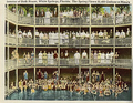 |
| 2nd | Williford # | Econfina Creek | GS | Washington Bay | 16.5 US gallons (62 L) | 70.0 °F (21.1 °C) | S |  |
| 3rd | Worthington | Santa Fe River | SS | Union | 0.2 US gallons (0.76 L) [6] | 68.0 °F (20.0 °C) [6] | C |  |