
Clay County is a county located in the northeastern part of the U.S. state of Florida along the west bank of the St. Johns River. As of 2020, the population was 218,245 and in 2023, that number increased to 232,439, making it the third largest county in the Jacksonville metropolitan area. While most of the county is unincorporated, there are 4 municipalities with Green Cove Springs being the county seat and the unincorporated Lakeside CDP being the largest place. It is named in honor of Henry Clay, a famous American statesman, member of the United States Senate from Kentucky, and United States Secretary of State in the 19th century.

The St. Johns River is the longest river in the U.S. state of Florida and it is the most significant one for commercial and recreational use. At 310 miles (500 km) long, it flows north and winds through or borders twelve counties. The drop in elevation from headwaters to mouth is less than 30 feet (9 m); like most Florida waterways, the St. Johns has a very slow flow speed of 0.3 mph (0.13 m/s), and is often described as "lazy".

Hamilton Disston was an American industrialist and real-estate developer who purchased 4 million acres (16,000 km²) of Florida land in 1881, an area larger than the state of Connecticut, and reportedly the most land ever purchased by a single person in world history. Disston was the son of Pennsylvania-based industrialist Henry Disston who formed Disston & Sons Saw Works, which Hamilton later ran and which was one of the largest saw manufacturing companies in the world.

The 74-mile-long (119 km) Ocklawaha River flows north from central Florida until it joins the St. Johns River near Palatka. Its name is derived from ak-lowahe, Creek for "muddy".

Hontoon Island State Park is a 1,648-acre (6.67 km2) Florida State Park located on Hontoon Island between the St. Johns River and the Hontoon Dead River in Volusia County. It is six miles (10 km) west of DeLand, off SR 44, and can only be reached by boat or park-operated passenger ferry. No motorized vehicles, other than wheelchairs, are allowed to be brought onto the island and there is no swimming. The island has pine flatwoods, palm and oak hammocks, bald cypress swamps and marshes. Hontoon Island is surrounded by the St. Johns River, the Hontoon Dead River, and Snake Creek.

The Little Manatee River flows 51 miles (82 km), from east of Fort Lonesome, Florida South of Hwy 674 and Earl Reynolds Rd In Hillsborough County through southern Hillsborough County, Florida including towns such as Sun City, Florida, and Gulf City, Florida and northern Manatee County, Florida into Tampa Bay. It has a drainage basin of 222 square miles (570 km2). It flows along the Little Manatee River State Park for part of its route. Portions of the river Such as Hayes Bayou and Mills Bayou have been designated as an Outstanding Florida Water and are part of the Cockroach Bay Aquatic Preserve.

Lake Washington is the largest lake in Brevard County, Florida at 4,362 acres (17.65 km2). The lake may have been named for the U.S. Deputy Surveyor Colonel Henry Washington, after he surveyed the area in 1844.
The Econlockhatchee River is an 54.5-mile-long (87.7 km) north-flowing blackwater tributary of the St. Johns River. The Econ River flows through Osceola, Orange, and Seminole counties in Central Florida, just east of the Orlando Metropolitan Area. It is a designated Outstanding Florida Waters.

Little Econlockhatchee River is a major tributary of the Econlockhatchee River. It originates at an unnamed lake at 28°33′47″N81°17′00″W, near Orlando, Florida in southeast Orange County. It is approximately 18 miles (29 km) long, from unincorporated Orange County to its mouth at Oviedo. It is located within the Middle St. Johns River Basin of the St. Johns River Water Management District. It is similar to the Econlockhatchee, with a forest in its floodplain. As far downstream as Blanchard Park, the river acts like a canal. The source elevation is 72 feet (22 m), higher than the source elevation of the tributary of the St. Johns River, the Econlockhatchee River. In August 2008, the river rose a record 4 feet (1.2 m) over its banks due to Tropical Storm Fay.
Shingle Creek is a small waterway in central Florida that is generally considered to be the northernmost headwaters of the Everglades watershed. It is named after the cypress trees that lined the bank in the late 19th century, which were used to make wood shingles. The stream and surrounding areas are protected wetlands.

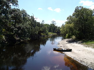
Black Creek is a tributary of the St. Johns River in Clay County, Florida. It is formed by the confluence of North Fork Black Creek and South Fork Black Creek. North Fork Black Creek originates as an outflow from Kingsley Lake and flows north and then southeast, meeting South Fork Black Creek on the east side of MIddleburg. North Fork Black Creek has Yellow Water Creek as its main tributary. South Fork Black Creek originates in a chain of lakes about four miles south of Kingsley Lake, with Ates Creek, Bull Creek, and Greens Creek as its main tributaries. Both forks are fed by areas of wetlands and numerous small streams.
The following is an alphabetical list of articles related to the U.S. state of Florida.

The Sandra Stetson Aquatic Center is a 10,000 square foot building and ten acre natural area located along Lake Beresford in DeLand, Florida. The facility is named in honor of Sandra Stetson, who provided a $6 million gift to support construction of the building and a botanical garden within the grounds. Sandra Stetson is the great granddaughter of famed hat-maker John B. Stetson, for whom Stetson University is named.

Palatka Heights is a neighborhood southwest of downtown Palatka, Florida in the United States. The area is bordered by St. Johns Avenue to the north, Westover Drive to the west, and the Ravine Gardens State Park to the south. The neighborhood houses the Palatka Water Works, which provided citizens with water from 1886 until the end of the 1980s. The City of Palatka Heights was incorporated July 23, 1886 and existed until its annexation by Palatka in 1921.
Blackwater Creek is an approximately 19 mile riverine feature in Florida. The creek flows from Lake Norris and has a confluence with the Wekiva River near where it in turn flows into the St. Johns River. The upper sections of Black Creek are traversed by kayak and canoe. Other sections a difficult to navigate due to snags.
Watson Island State Forest is located in St. Johns County, Florida. The state forest includes 199 acres of Bottomland Forest, 129 acres of Wet Flatwoods, 124 acres of Mesic Flatwoods, 26 acres of floodplain, 23 acres of Baygall forest, 2 acres of Floodplain Marsh, 2 acres of ruderal and 1 acre of dome swamp.
The Clermont chain of lakes is a chain of lakes centered on Clermont, Florida. The chain is orientated from southeast to northwest and fed primarily by streams and groundwater flow. They make up the middle part of the Palatlakaha River watershed which forms the headwaters of the Ocklawaha River. The lakes are notable for their red to tea-colored water from tannic acid.
Deep Creek Preserve is an 8,040 acre conservation area in Volusia County, Florida. The preserve was created in 2010 after the county purchased a ranch. The preserve protects water supplies and is part of a wildlife corridor connecting the Everglades in south Florida to Okefenokee National Wildlife Refuge on the Florida/Georgia line.
