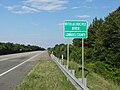
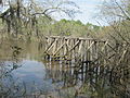
Withlacoochee River (Suwannee River tributary)

Last updated
Withlacoochee River near the confluence with the Suwannee River Withlacoochee River (Suwannee River tributary).jpg
Withlacoochee River near the confluence with the Suwannee River
Withlacoocheenorthrivermap.png

The Withlacoochee River originates in Georgia, northwest of Nashville, Georgia. It flows south through Berrien County where it joins the New River and forms part of the boundary between Berrien and Cook counties. It then flows south into Lowndes County, Georgia. At Troupville, Georgia the Little River joins the Withlacoochee River flows continues to flow south and forms part of the boundary between Lowndes and Brooks counties in Georgia. The river then flows into Florida for 1.34 miles before returning into Georgia for an additional 2.44 miles. It then returns to Florida, forming the northeast boundary of Madison County, Florida and the western boundary of Hamilton County, Florida and eventually merges with the Suwannee at Suwannee River State Park west of Live Oak. The river is 115 miles (185 km) long. [1]

Contents

A river in central Florida is also named the Withlacoochee.

Etymology

The Withlacoochee River received its name from the indigenous Muscogee and Seminole people. It comes from the compound Creek word ue-rakkuce [IPA: wiɬakːut͡ʃi], from ue "water", rakko "big", and -uce "small", with the rough translation "little river." [2] [3] English speakers then changed the Muskogee voiceless lateral spelled r to "thl".

Crossings

CrossingRiver MilesCarriesImageLocationID numberCoordinates

Georgia

SP4 Derrell Danforth Bridge~115 Georgia 354.svg SR 354 Lenox, Georgia to Alapaha, Georgia 31°19′21″N83°17′51″W / 31.322594°N 83.297435°W / 31.322594; -83.297435
Oak Ford Bridge~106 Georgia 125.svg SR 125 Tifton, Georgia to Nashville, Georgia 31°12′54″N83°16′09″W / 31.215092°N 83.269252°W / 31.215092; -83.269252
Georgia and Florida Railroad (Abandoned 1967)
Line was formerly known as the Nashville and Sparks Railroad
31°12′20″N83°16′22″W / 31.205501°N 83.272724°W / 31.205501; -83.272724
POW Fred L. Belcher Bridge~105 Georgia 76.svg SR 76 Adel, Georgia to Nashville, Georgia 31°11′50″N83°16′18″W / 31.197289°N 83.271790°W / 31.197289; -83.271790
Shellie W. Parrish Memorial Bridge
aka Williams Bridge
97.65 [4] Georgia 37.svg SR 37
Adel, Georgia to Ray City, Georgia 31°07′13″N83°19′17″W / 31.120233°N 83.321272°W / 31.120233; -83.321272
B Williams BridgeOld Lois Road (Closed) 31°07′58″N83°18′45″W / 31.132777°N 83.312516°W / 31.132777; -83.312516
Futchs Bridge/Ferry95.2 Coffee Road 31°05′46″N83°19′00″W / 31.096088°N 83.316711°W / 31.096088; -83.316711
Hagan Bridge84.7 Georgia 122.svg SR 122 Withlacoochee River sign, GA 122, Lowndes County.JPG Hahira, Georgia to Lakeland, Georgia 31°00′50″N83°18′06″W / 31.013867°N 83.301798°W / 31.013867; -83.301798
Tyler Bridge79.8Franklinville Road (Closed) 30°58′53″N83°16′04″W / 30.981372°N 83.267727°W / 30.981372; -83.267727
Skipper BridgeReed Road (Defunct) 30°57′25″N83°16′11″W / 30.957000°N 83.269800°W / 30.957000; -83.269800
New Skipper Bridge76.3Skipper Bridge Road 30°56′57″N83°16′19″W / 30.949038°N 83.271902°W / 30.949038; -83.271902
Staten Road Bridge74.3Staten Road 30°55′59″N83°17′20″W / 30.932936°N 83.289006°W / 30.932936; -83.289006
Fender BridgeStaten Road (Defunct since before 1990s) 30°55′59″N83°17′21″W / 30.933004°N 83.289189°W / 30.933004; -83.289189
Double Bridges69.1 US 41.svg US 41
Georgia 7.svg SR 7
Valdosta, Georgia 30°53′34″N83°19′08″W / 30.892708°N 83.318815°W / 30.892708; -83.318815
Norfolk Southern Railway
Line formerly known as Georgia Southern and Florida Railway
Valdosta, Georgia 30°51′48″N83°19′18″W / 30.863285°N 83.321587°W / 30.863285; -83.321587
63.5 I-75.svg Interstate 75 Troupville, Georgia 30°51′18″N83°20′04″W / 30.855028°N 83.334319°W / 30.855028; -83.334319
62.6 Georgia 133.svg SR 133 Troupville, Georgia 30°51′00″N83°20′22″W / 30.849994°N 83.339580°W / 30.849994; -83.339580
Valdosta, Moultrie and Western Railroad (Closed 1923, now defunct) 30°50′28″N83°21′12″W / 30.841114°N 83.353470°W / 30.841114; -83.353470
51.8 US 84.svg US 221.svg US 84/221
Georgia 38.svg SR 38
Lowndes County line, US84EB.JPG Ousley, Georgia to Quitman, Georgia 30°47′37″N83°27′13″W / 30.793568°N 83.453476°W / 30.793568; -83.453476
Spook Bridge 51.7Old Quitman Highway (Closed)Blue Springs, Georgia 30°47′23″N83°27′06″W / 30.789828°N 83.451651°W / 30.789828; -83.451651
51.7 CSX Transportation
Line was formerly known as the Atlantic and Gulf Railroad
30°47′34″N83°27′12″W / 30.792882°N 83.453391°W / 30.792882; -83.453391
Spains Bridge/FerryHistorically Spains Ferry Road (Defunct)Spains Ferry 30°44′57″N83°28′57″W / 30.749137°N 83.482455°W / 30.749137; -83.482455
Knights Bridge/FerryHistorically Knights Ferry Road (Defunct)Knights Ferry 30°42′40″N83°27′17″W / 30.711146°N 83.454755°W / 30.711146; -83.454755
Rocky Ford Bridge36.7Rocky Ford Road/Clyattville-Nankin RoadRocky Ford 30°40′30″N83°23′40″W / 30.674944°N 83.394416°W / 30.674944; -83.394416

Georgia – Florida

31.1 Valdosta Railway (Closed 1973) Old Valdosta Railway Bridge on the Withlacochee River.JPG 30°38′12″N83°21′02″W / 30.636634°N 83.350468°W / 30.636634; -83.350468

Georgia

Horns Ferry Bridge27.8 Georgia 31.svg SR 31

Florida 145.svg SR 145

Georgia State Route 31 bridge, Aug 2015 c.JPG Clyattville, Georgia to Pinetta, Florida 30°38′07″N83°18′42″W / 30.635379°N 83.311598°W / 30.635379; -83.311598
Old Horns Ferry Bridge27.7(Built 1895, closed 1940, defunct) Clyattville, Georgia to Pinetta, Florida 30°38′07″N83°18′35″W / 30.635298°N 83.309595°W / 30.635298; -83.309595

Florida

22.4 Florida 150.svg SR 150 Withacoochee River (Northern One) SR 150.jpg Bellville, Florida 30°35′48″N83°15′35″W / 30.596707°N 83.259861°W / 30.596707; -83.259861
22.3(Defunct)Bellville, Florida 30°35′45″N83°15′34″W / 30.595830°N 83.259471°W / 30.595830; -83.259471
(Defunct) Madison Blue Spring State Park 30°28′58″N83°14′37″W / 30.482897°N 83.243676°W / 30.482897; -83.243676
12.0 Florida 6.svg SR 6 Madison Blue Spring State Park 320016 30°28′56″N83°14′36″W / 30.482288°N 83.243448°W / 30.482288; -83.243448
West Bridge2.3 Florida 141.svg SR 141 FL CR 141 Withlacoochee River bridge east01.jpg 30°24′37″N83°10′48″W / 30.410215°N 83.179994°W / 30.410215; -83.179994

Notes

  1. U.S. Geological Survey. National Hydrography Dataset high-resolution flowline data. The National Map, accessed April 18, 2011
  2. Simpson, J. Clarence (1956). Mark F. Boyd (ed.). Florida Place-Names of Indian Derivation. Tallahassee, Florida: Florida Geological Survey.
  3. Martin, Jack B.; Mauldin, Margaret McKane (2004-12-01). A Dictionary of Creek/Muskogee. U of Nebraska Press. p. 183. ISBN   0803283024.
  4. "Sponsors up and down I-75 on Water Trail Brochures | WWALS Watershed Coalition (WWALS) is Suwannee RIVERKEEPER®".

30°23′14.2″N83°10′17.9″W / 30.387278°N 83.171639°W / 30.387278; -83.171639


Related Research Articles

<span class="mw-page-title-main">Tift County, Georgia</span> County in Georgia, United States

Tift County is a county located in the south central portion of the U.S. state of Georgia. As of the 2020 census, the population was 41,344. The county seat is Tifton.

<span class="mw-page-title-main">Lowndes County, Georgia</span> County in Georgia, United States

Lowndes County is a county located in the south-central portion of the U.S. state of Georgia. As of the 2020 census, the population was 118,251. The county seat is Valdosta. The county was created December 23, 1825.

<span class="mw-page-title-main">Lanier County, Georgia</span> County in Georgia, United States

Lanier County is a county in the south central portion of the U.S. state of Georgia. As of the 2020 census, the population was 9,877. The county seat and only incorporated municipality is Lakeland. The county is named after the Georgia poet Sidney Lanier.

<span class="mw-page-title-main">Irwin County, Georgia</span> County in Georgia, United States

Irwin County is a county located in the U.S. state of Georgia. As of the 2020 census, the population was 9,666. The county seat is Ocilla. The county was created on December 15, 1818. It was named for Governor Jared Irwin.

<span class="mw-page-title-main">Echols County, Georgia</span> County in Georgia, United States

Echols County is a county located in the southeastern part of the U.S. state of Georgia. As of the 2020 census, the population was 3,697. The county seat is Statenville. Since 2008, Statenville is a disincorporated municipality. Echols and Webster counties are the only two counties in Georgia to currently have no incorporated municipalities. The county was established in 1858 and named in honor of Robert Milner Echols (1798–1847).

<span class="mw-page-title-main">Cook County, Georgia</span> County in Georgia, United States

Cook County is a county located in the south central portion of the U.S. state of Georgia. As of the 2020 census, the population was 17,229. The county seat is Adel. The constitutional amendment to create the county was proposed July 30, 1918, and ratified November 5, 1918. It is named for former Civil War general Philip Cook of the Confederate States Army.

<span class="mw-page-title-main">Brooks County, Georgia</span> County in Georgia, United States

Brooks County is a county located in the U.S. state of Georgia, on its southern border with Florida. As of the 2020 census, the population was 16,301. The county seat is Quitman. The county was created in 1858 from portions of Lowndes and Thomas counties by an act of the Georgia General Assembly and was named for pro-slavery U.S. Representative Preston Brooks, after he severely beat abolitionist Senator Charles Sumner with a cane for delivering a speech attacking slavery.

<span class="mw-page-title-main">Berrien County, Georgia</span> County in Georgia, United States

Berrien County is a county located in the south central portion of the U.S. state of Georgia. As of the 2020 census, the population was 18,160. The county seat is Nashville. The county was created February 25, 1856 out of portions of Coffee, Irwin and Lowndes counties by an act of the Georgia General Assembly. It is named after Georgia senator John M. Berrien.

<span class="mw-page-title-main">Ray City, Georgia</span> City in Georgia, United States

Ray City is a city in Berrien County and Lanier County, Georgia, United States. The population was 956 in 2020.

<span class="mw-page-title-main">Suwannee River</span> 396km (246mi) river in Florida and Georgia, USA

The Suwannee River is a river that runs through south Georgia southward into Florida in the Southern United States. It is a wild blackwater river, about 246 miles (396 km) long. The Suwannee River is the site of the prehistoric Suwanee Straits that separated the Florida peninsula from the Florida panhandle and the rest of the continent.

<span class="mw-page-title-main">Alapaha River</span> River in Georgia and Florida, United States

The Alapaha River is a 202-mile-long (325 km) river in southern Georgia and northern Florida in the United States. It is a tributary of the Suwannee River, which flows to the Gulf of Mexico.

<span class="mw-page-title-main">Aucilla River</span> River in Florida and Georgia, United States

The Aucilla River rises in Brooks County, Georgia, USA, close to Thomasville, and passes through the Big Bend region of Florida, emptying into the Gulf of Mexico at Apalachee Bay. Some early maps called it the Ocilla River. It is 89 miles (143 km) long and has a drainage basin of 747 square miles (1,930 km2). Tributaries include the Little Aucilla and Wacissa Rivers. In Florida, the Aucilla River forms the eastern border of Jefferson County, separating it from Madison County on the northern part, and from Taylor County to the south.

<span class="mw-page-title-main">Withlacoochee River (Florida)</span> River in Florida, United States

The Withlacoochee River or Crooked River is a river in central Florida, in the United States. It originates in the Green Swamp, east of Polk City, flowing west, then north, then northwest and finally west again before emptying into the Gulf of Mexico near Yankeetown. The river is 141 miles (227 km) long and has a drainage basin of 1,170 square miles (3,000 km2).

<span class="mw-page-title-main">Suwannee River Water Management District</span> Responsible for managing groundwater and surface water

The Suwannee River Water Management District (SRWMD) is responsible for managing groundwater and surface water resources in a 15-county region in north-central Florida, United States. It is the smallest of five Florida water management districts. Its district headquarters are in Live Oak, Florida.

The Alapahoochee River is a 14.4-mile-long (23.2 km) tributary of the Alapaha River in Georgia and Florida in the United States. Via the Alapaha and Suwannee rivers, its waters flow to the Gulf of Mexico.

<span class="mw-page-title-main">Little River (Withlacoochee River tributary)</span> River in the United States

The Little River is a 105-mile-long (169 km) tributary of the Withlacoochee River in the U.S. state of Georgia. Via the Withlacoochee and the Suwannee River its waters flow to the Gulf of Mexico. The Little River was also known historically as the Ockolocoochee River.

The New River is a 34.4-mile-long (55.4 km) tributary of the Withlacoochee River in the U.S. state of Georgia. Via the Withlacoochee and Suwannee rivers, its waters flow to the Gulf of Mexico.

Okapilco Creek is a 63-mile-long (101 km) tributary of the Withlacoochee River in the U.S. state of Georgia. Via the Withlacoochee and the Suwannee River, the waters of Okapilco Creek flow to the Gulf of Mexico.

<span class="mw-page-title-main">Willacoochee River</span> River in the United States

The Willacoochee River is a 21.5-mile-long (34.6 km) tributary of the Alapaha River in the U.S. state of Georgia. Via the Alapaha and Suwannee rivers, its waters flow to the Gulf of Mexico.