
Cordele is a city in and the county seat of Crisp County, Georgia. The population was 11,165 at the 2010 census.

Beaver Lake is a man-made reservoir in the Ozark Mountains of Northwest Arkansas and is formed by a dam across the White River. Beaver Lake has some 487 miles (784 km) of shoreline. With towering limestone bluffs, natural caves, and a wide variety of trees and flowering shrubs, it is a popular tourist destination. Beaver Lake is the source of drinking water in Northwest Arkansas, which is managed, treated and sold by Beaver Water District, serving more than 450,000 customers. One out of 7 people in Arkansas get their drinking water from Beaver Lake.

Toledo Bend Reservoir is a reservoir on the Sabine River between Texas and Louisiana. The lake has an area of 185,000 acres (750 km2), the largest man-made body of water partially in both Louisiana and Texas, the largest in the South, and the fifth largest by surface acre in the United States. The dam is capable of generating 92 megawatts of electrical power. The dam itself is located in the northeast corner of Newton County, Texas; however, that county includes very little of the reservoir, as most of it extends northward into parts of Sabine and DeSoto parishes in Louisiana, and Sabine, Shelby, and Panola counties in Texas.
The Flint River is a 344-mile-long (554 km) river in the U.S. state of Georgia. The river drains 8,460 square miles (21,900 km2) of western Georgia, flowing south from the upper Piedmont region south of Atlanta to the wetlands of the Gulf Coastal Plain in the southwestern corner of the state. Along with the Apalachicola and the Chattahoochee rivers, it forms part of the ACF basin. In its upper course through the red hills of the Piedmont, it is considered especially scenic, flowing unimpeded for over 200 miles (320 km). Historically, it was also called the Thronateeska River.

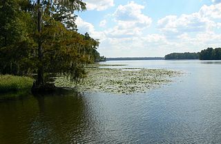
George L. Smith State Park is a 1,634-acre (6.61 km2) Georgia state park located in Emanuel County. The park is named after George L. Smith, a former speaker of the Georgia House of Representatives and Emanuel County native. Attractions include a grist mill, covered bridge, and the dam of the Parrish Mill. The park's location on a 412-acre (1.67 km2) mill pond dotted with many cypress trees makes it a destination for anglers and canoeists. The moderately-sized state park is in a remote location, making it an attraction for bird watchers and naturalists. Rare birds in residence include the great blue heron and the white ibis.

The Great Sacandaga Lake is a large lake situated in the Adirondack Park in northern New York in the United States. The lake has a surface area of about 41.7 square miles (108 km2) at capacity, and the length is about 29 miles (47 km). The word Sacandaga means "Land of the Waving Grass" in the local native language. The lake is located in the northern parts of Fulton County and Saratoga County near the southern border of the Adirondack Park. A small portion also extends northward into southern Hamilton County. The broader, south end of the lake is northeast of the City of Johnstown and the City of Gloversville. Great Sacandaga Lake is a reservoir created by damming the Sacandaga River. The primary purpose for the creation of the reservoir was to control flooding on the Hudson River and the Sacandaga River, floods which had a historically significant impact on the surrounding communities.

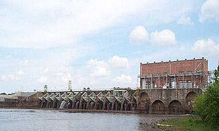
Bagnell Dam impounds the Osage River in the U.S. state of Missouri, creating the Lake of the Ozarks. The dam is located in the city of Lakeside in Miller County, near the Camden-Miller County line. The 148-foot (45 m) tall concrete gravity dam was built by the Union Electric Company to generate hydroelectric power at its Osage Powerplant. It is 2,543 feet (775 m) long, including a 520-foot (160 m) long spillway and a 511-foot (156 m) long power station. The facility with eight generators has a maximum capacity of 215 megawatts. The dam provides power to 42,000 homes.

Lake Cumberland is a reservoir in Clinton, Pulaski, Russell, Wayne, and Laurel, counties in Kentucky. The primary reasons for its construction were a means for flood control and the production of hydroelectric power. Its shoreline measures 1,255 miles (2,020 km) and the lake covers 65,530 acres (265 km2) at the maximum power pool elevation. The reservoir ranks 9th in the U.S. in size, with a capacity of 6,100,000 acre-feet (7.5 km3) of water, enough to cover the entire Commonwealth of Kentucky with 3 inches (76 mm) of water. The main lake is 101 miles (163 km) long and over one mile (1.6 km) across at its widest point.

Lake Murray is a reservoir in the U.S. state of South Carolina. It is approximately 50,000 acres in size, and has roughly 650 mi of shoreline. It was impounded in the late 1920s to provide hydroelectric power to the state of South Carolina. Lake Murray is fed by the Saluda River, which flows from upstate South Carolina near the North Carolina state line. The Saluda Dam was an engineering feat at the time of its construction. The dam, using the native red clay soil and bedrock, was the largest earthen dam in the world when it was completed in 1930. Lake Murray itself is named after the project's chief engineer, William S. Murray. The Saluda Dam is approximately 1.5 miles (2.4 km) long and 220 feet (67 m) high. Lake Murray is 41 miles (66 km) long, and 14 miles (23 km) wide at its widest point. At the time when the lake was finished, it was the world's largest man-made reservoir.
Lake Talquin is a reservoir located on the Ochlockonee River between Leon County and Gadsden County in north Florida. The lake, located about 10 miles (15 km) west of Tallahassee, is south of Interstate 10 and bordered by State Road 20 on the east and State Road 267 on the west.

The Ashokan Reservoir is a reservoir in Ulster County, New York. It is at the eastern end of the Catskill Park, and is one of several in the region created to provide the City of New York with water. It is the city's deepest reservoir at 190 feet (58 m) near the dam at the former site of Bishop Falls.
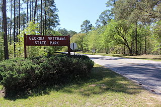
Georgia Veterans State Park is a state park located on Lake Blackshear in Crisp County, west of Cordele, Georgia. It was established on December 4, 1946 as a memorial to U.S. Veterans. The 1,308-acre (5 km2) park features a museum with aircraft, vehicles, weapons, uniforms and other memorabilia dating from the Revolutionary War to the present.

Lake Sinclair is a man-made lake in central Georgia near Milledgeville. It is operated by Georgia Power.

Lake Keowee is a man-made reservoir in the United States in the state of South Carolina. It was developed to serve the needs of power utility Duke Energy and public recreational purposes. It is approximately 26 miles (42 km) long, 3 miles (4.8 km) wide, with an average depth of 54 feet (16 m), and a shoreline measured at 300 miles (480 km) in total, and is approximately 800 feet (240 m) above sea level.

Whipple Dam State Park is a Pennsylvania state park on 256 acres (104 ha) in Jackson Township, Huntingdon County, Pennsylvania in the United States. Whipple Lake is a man-made lake on 22 acres (8.9 ha) that was originally built during the height of the lumber era that swept through Pennsylvania in the late 19th and early 20th century to supply power for a sawmill. Whipple Dam State Park is 12 miles (19 km) south of State College, just east of Pennsylvania Route 26.
Parker Dam State Park is a 968-acre (392 ha) Pennsylvania state park in Huston Township, Clearfield County, Pennsylvania in the United States. The park is surrounded by Moshannon State Forest. Parker Dam State park is 17 miles (27 km) north of Clearfield on Pennsylvania Route 153 just off exit 111 of Interstate 80. The park was constructed during the Great Depression by the Civilian Conservation Corps; they built many of the facilities that are in use today at Parker Dam State Park.

Little Buffalo State Park is a Pennsylvania state park on 923 acres (3.7 km2) in Centre and Juniata Townships, Perry County, Pennsylvania in the United States. The park is a historical destination as well as a recreational destination. Visitors to the park can cross a covered bridge and observe a restored and operating grist mill. The park is also home to Holman Lake a popular fishing lake in Perry County and several hundred acres are open to hunting. Little Buffalo State Park is a mile southwest of Newport just off Pennsylvania Route 34.
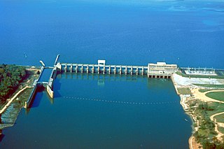
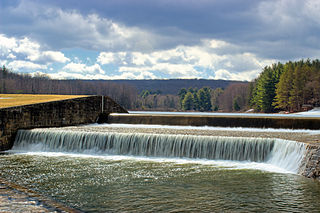
In 1925, after an amendment was made to the Georgian constitution, the Crisp County Power Commission (CCPC) was established. The amendment was the result of a petition made by a group of residents from Crisp County to develop a hydroelectric power system along the Flint River. Georgia government officials decided to build a power-dam in order to satisfy the Crisp County resident's request. The Crisp County Hydroelectric Power Dam, proposed by CCPC, was the first power-dam in the United States to be owned, built and operated by a county.


