Spring Creek (Flint River tributary)

Last updated
Spring Creek
Country United States
Physical characteristics
Main source Georgia

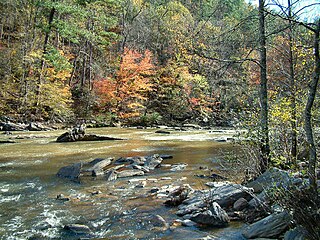
Spring Creek is a 76.5-mile-long (123.1 km) [1] tributary of the Flint River in southwest Georgia in the United States.

Flint River (Georgia) river in the United States of America

The Flint River is a 344-mile-long (554 km) river in the U.S. state of Georgia. The river drains 8,460 square miles (21,900 km2) of western Georgia, flowing south from the upper Piedmont region south of Atlanta to the wetlands of the Gulf Coastal Plain in the southwestern corner of the state. Along with the Apalachicola and the Chattahoochee rivers, it forms part of the ACF basin. In its upper course through the red hills of the Piedmont, it is considered especially scenic, flowing unimpeded for over 200 miles (320 km). Historically, it was also called the Thronateeska River.

Georgia (U.S. state) State of the United States of America

Georgia is a state in the Southeastern United States. It began as a British colony in 1733, the last and southernmost of the original Thirteen Colonies to be established. Named after King George II of Great Britain, the Province of Georgia covered the area from South Carolina south to Spanish Florida and west to French Louisiana at the Mississippi River. Georgia was the fourth state to ratify the United States Constitution, on January 2, 1788. In 1802–1804, western Georgia was split to the Mississippi Territory, which later split to form Alabama with part of former West Florida in 1819. Georgia declared its secession from the Union on January 19, 1861, and was one of the original seven Confederate states. It was the last state to be restored to the Union, on July 15, 1870. Georgia is the 24th largest and the 8th most populous of the 50 United States. From 2007 to 2008, 14 of Georgia's counties ranked among the nation's 100 fastest-growing, second only to Texas. Georgia is known as the Peach State and the Empire State of the South. Atlanta, the state's capital and most populous city, has been named a global city. Atlanta's metropolitan area contains about 55% of the population of the entire state.

Rising in the northeastern corner of Clay County, 5 miles (8 km) north of Bluffton, the creek flows south to join the Flint River in Lake Seminole, approximately 6 miles (10 km) upstream of that river's confluence with the Chattahoochee River to form the Apalachicola River, which flows through Florida to the Gulf of Mexico.

Clay County, Georgia county located in the U.S. state of Georgia

Clay County is a county located in the U.S. state of Georgia. As of the 2010 census, the population was 3,183, making it the fifth-least populous county in Georgia. The county seat is Fort Gaines.

Bluffton, Georgia Town in Georgia, United States

Bluffton is a town in Clay County, Georgia, United States. As of the 2010 census, the city had a population of 103.

Lake Seminole reservoir in northwestern Florida formed by the Jim Woodruff Dam on the Apalachicola River

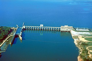
Lake Seminole is a reservoir located in the southwest corner of Georgia along its border with Florida, maintained by the U.S. Army Corps of Engineers. The Chattahoochee and Flint rivers join in the lake, before flowing from the Jim Woodruff Lock and Dam, which impounds the lake, as the Apalachicola River. The lake contains 37,500 acres (152 km2) of water, and has a shoreline of 376 mi (605 km). The fish in Lake Seminole include largemouth bass, crappie, chain pickerel, catfish, striped bass and other species. American alligators, snakes and various waterfowl are also present in the lake, which is known for its goose hunting.

See also

Related Research Articles

Au Sable River (Michigan) river in Michigan

The Au Sable River in Michigan, United States runs approximately 138 miles (222 km) through the northern Lower Peninsula, through the towns of Grayling and Mio, and enters Lake Huron at Au Sable. It is considered one of the best brown trout fisheries east of the Rockies and has been designated a blue ribbon trout stream by the Michigan Department of Natural Resources. In French, au sable literally means "at the sand." A 1795 map calls it the Beauais River.

Stillwater River (Ohio) tributary of the Great Miami River in Ohio, United States

The Stillwater River is a 69.3-mile-long (111.5 km) tributary of the Great Miami River in western Ohio in the United States. Via the Great Miami and Ohio rivers, it is part of the Mississippi River watershed.

Elkhorn Creek (Kentucky) river in the United States of America

Elkhorn Creek is an 18.3-mile-long (29.5 km) stream running through several counties in central Kentucky in the United States. The stream drains an area of 499.5 square miles (1,294 km2). It derives its name from the shape, as seen on a map, of its main stem with its two primary forks.

Sweetwater Creek (Chattahoochee River tributary) river in the United States of America

Sweetwater Creek is a 45.6-mile-long (73.4 km) stream in the U.S. state of Georgia, west of Atlanta. It begins in southwestern Paulding County, flowing generally eastward into southwestern Cobb County, then turning south into eastern Douglas County. It is a tributary of the Chattahoochee River, and near its end it is the centerpiece of Sweetwater Creek State Park.

Muckalee Creek is a creek in southwest Georgia. It originates southeast of Buena Vista and flows south-southeast for 76.3 miles (122.8 km) and into Kinchafoonee Creek north of Albany, just upstream of that creek's confluence with the Flint River. It is also the subject of a country song by Luke Bryan titled "Muckalee Creek Water".

Kinchafoonee Creek is a creek in southwest Georgia. It originates near Buena Vista and flows southeasterly for 91.8 miles (147.7 km) to the Flint River near Albany, Georgia.

Withlacoochee River (Suwannee River tributary) river in the United States of America

The Withlacoochee River originates in Georgia, northwest of Nashville, Georgia. It flows south through Berrien County where it joins the New River and forms part of the boundary between Berrien and Cook counties. It then flows south into Lowndes County, Georgia. At Troupville, Georgia the Little River joins the Withlacoochee River flows continues to flow south and forms part of the boundary between Lowndes and Brooks counties in Georgia. The river then flows into Florida for 1.34 miles Florida before returning into Georgia for an additional 2.44 miles. It then returns to Florida, forming the northeast boundary of Madison County, Florida and the western boundary of Hamilton County, Florida and eventually merges with the Suwannee at Suwannee River State Park west of Live Oak. The river is 115 miles (185 km) long. It is believed to be the source for the name of the central Florida river of the same name.

Devils Lake is the name of a few lakes in the U.S. state of Michigan.

Little River (Etowah River tributary)

The Little River is a 29.3-mile-long (47.2 km) tributary of the Etowah River in the U.S. state of Georgia in the United States.

The Alapahoochee River is a 14.4-mile-long (23.2 km) tributary of the Alapaha River in Georgia and Florida in the United States. Via the Alapaha and Suwannee rivers, its waters flow to the Gulf of Mexico.

The Crescent River is a 5.4-mile-long (8.7 km) tidal river in McIntosh County, Georgia, in the United States. It forms in salt marshes east of the community of Bellville Point and flows southeast, ending at a river junction where the Mud River flows northeast into Sapelo Sound and Old Teakettle Creek flows south to Doboy Sound.

Little Satilla Creek river in the United States of America

The Little Satilla Creek is a 39.3-mile-long (63.2 km) tributary of the Little Satilla River in the U.S. state of Georgia. It is part of the Satilla River watershed in southeastern Georgia.

Little Satilla River (Satilla River) river in the United States of America

The Little Satilla River is a 28.4-mile-long (45.7 km) freshwater tributary of the Satilla River in the U.S. state of Georgia. It should not be confused with the tidal Little Satilla River that is 20 miles (32 km) to the southeast and is an inlet of the Atlantic Ocean.

Okapilco Creek is a 63-mile-long (101 km) tributary of the Withlacoochee River in the U.S. state of Georgia. Via the Withlacoochee and the Suwannee River, the waters of Okapilco Creek flow to the Gulf of Mexico.

Rocky Comfort Creek is a 62.4-mile-long (100.4 km) tributary of the Ogeechee River in the U.S. state of Georgia. Rising in Warren County 9 miles (14 km) northwest of Warrenton, it flows southeast, entering Glascock County and passing the town of Gibson, then continuing south into Jefferson County, where it reaches the Ogeechee River at Louisville.

Suwannoochee Creek is a 49.0-mile-long (78.9 km) tributary of the Suwannee River in the U.S. state of Georgia. It rises in western Clinch County, Georgia, about 11 miles (18 km) west of Homerville, and flows southeast to join the Suwannee near Fargo. For the lower half of its course it forms the boundary between Clinch and Echols counties.

Willacoochee River river in the United States of America

The Willacoochee River is a 21.5-mile-long (34.6 km) tributary of the Alapaha River in the U.S. state of Georgia. Via the Alapaha and Suwannee rivers, its waters flow to the Gulf of Mexico.

The Williamson Swamp Creek is a 52.4-mile-long (84.3 km) tributary of the Ogeechee River in the U.S. state of Georgia. Rising in northwestern Washington County 12 miles (19 km) north of Sandersville, it flows southeast past Davisboro and enters Jefferson County, ending at the Ogeechee River 5 miles (8 km) southeast of Wadley.

Walnut Creek is a 30-mile-long (48 km) tributary of the South River in the U.S. state of Georgia. It originates in the city of Hampton in Henry County and flows into South River, which is a branch of the Ocmulgee River.

References

  1. U.S. Geological Survey. National Hydrography Dataset high-resolution flowline data. The National Map, accessed April 15, 2011

Coordinates: 30°48′08″N84°47′14″W / 30.80213°N 84.78714°W / 30.80213; -84.78714

Geographic coordinate system Coordinate system

A geographic coordinate system is a coordinate system that enables every location on Earth to be specified by a set of numbers, letters or symbols. The coordinates are often chosen such that one of the numbers represents a vertical position and two or three of the numbers represent a horizontal position; alternatively, a geographic position may be expressed in a combined three-dimensional Cartesian vector. A common choice of coordinates is latitude, longitude and elevation. To specify a location on a plane requires a map projection.