
Hiawatha National Forest is a 894,836-acre (362,127 ha) National Forest in the Upper Peninsula of the state of Michigan in the United States. Commercial logging is conducted in some areas. The United States Forest Service administers this National Forest; it is physically divided into two subunits, commonly called the Eastside 46°14′N84°50′W and Westside 46°08′N86°40′W. In descending order of land area it lies in parts of Chippewa, Delta, Mackinac, Alger, Schoolcraft, and Marquette counties. Chippewa and Mackinac counties are in the Eastside, whereas the rest are in the Westside. The smaller Eastside contains about 44% of the forest's area, whereas the larger Westside has about 56%. Forest headquarters are located in Escanaba, Michigan. Eastside ranger district offices are located in Sault Ste. Marie and St. Ignace, while Westside offices are in Manistique, Munising, and Rapid River.

The Huron-Manistee National Forests are two separate national forests, the Huron National Forest and the Manistee National Forest, combined in 1945 for administration purposes and which comprise 978,906 acres (3,960 km2) of public lands, including 5,786 acres (23 km2) of wetlands, extending across the northern lower peninsula of Michigan. The Huron-Manistee National Forests provide recreation opportunities for visitors, habitat for fish and wildlife, and resources for local industry. The headquarters for the forests is in Cadillac, Michigan.

The Huron National Forest is a National Forest in the Lower Peninsula of Michigan. It was established in 1909 after the logging era began to decline. In 1945, it was administratively combined with the Manistee National Forest, to create the Huron-Manistee National Forest. However, these are not connected and are separate forests. It provides recreation opportunities for visitors, habitat for fish and wildlife, and resources for local industry. The headquarters for the forest is located in Cadillac, Michigan.
The Cherokee National Forest is a large National Forest created on June 14, 1920 and managed by the U.S. Forest Service and encompassing some 655,598 acres (2,653.11 km2).

The George Washington and Jefferson National Forests are U.S. National Forests that combine to form one of the largest areas of public land in the Eastern United States. They cover 1.8 million acres (7,300 km2) of land in the Appalachian Mountains of Virginia, West Virginia, and Kentucky. Approximately 1 million acres (4,000 km2) of the forest are remote and undeveloped and 139,461 acres (564 km2) have been designated as wilderness areas, which eliminates future development.

The Mendocino Woodlands State Park is a group camping facility located at 39350 Little Lake Road, Mendocino County, California, seven miles (11 km) inland from the town of Mendocino. It was built as a Recreational Demonstration Area by the Civilian Conservation Corps. Mendocino Woodlands consists of approximately 700 acres (2.8 km2) of land along the Little North Fork of the Big River and is surrounded to the north, east, and west by the 50,000-acre (200 km²) Jackson Demonstration State Forest. To the south, the park abuts the Big River State Park. It was declared a National Historic Landmark on September 25, 1997.
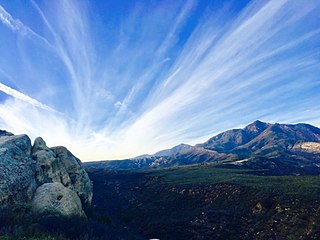
Los Padres National Forest is a United States national forest in southern and central California. Administered by the United States Forest Service, Los Padres includes most of the mountainous land along the California coast from Ventura to Monterey, extending inland. Elevations range from sea level to 8,847 feet (2,697 m).

The Shasta–Trinity National Forest is a federally designated forest in northern California, USA. It is the largest National Forest in California and is managed by the U.S. Forest Service. The 2,210,485 acre forest encompasses five wilderness areas, hundreds of mountain lakes and 6,278 miles (10,103 km) of streams and rivers. Major features include Shasta Lake, the largest man-made lake in California and Mount Shasta, elevation 14,179 feet (4,322 m).

Lassen National Forest is a United States national forest of 1,700 square miles (4,300 km2) in northeastern California. It is named after pioneer Peter Lassen, who mined, ranched and promoted the area to emigrant parties in the 1850s.
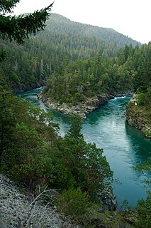
Six Rivers National Forest is a U.S. National Forest located in the northwestern corner of California. It was established on June 3, 1947 by U.S. President Harry S. Truman from portions of Klamath, Siskiyou and Trinity National Forests. Its over one million acres (4,000 km2) of land contain a variety of ecosystems and 137,000 acres (550 km2) of old growth forest. It lies in parts of four counties; in descending order of forestland area they are Del Norte, Humboldt, Trinity, and Siskiyou counties. The forest is named after the Eel, Van Duzen, Klamath, Trinity, Mad, and Smith rivers, which pass through or near the forest's boundaries.

The Chattahoochee-Oconee National Forest in northern Georgia comprises two United States National Forests, the Oconee National Forest in eastern Georgia and the Chattahoochee National Forest located in the North Georgia Mountains. The Chattahoochee National Forest is composed of an eastern and western forest. The western forest contains Johns Mountain, Little Sand Mountain, and Taylor Ridge. The combined total area of the Chattahoochee-Oconee National Forest is 866,468 acres (3,506 km2), of which the Chattahoochee National Forest comprises 750,145 acres (3,036 km2) and the Oconee National Forest comprises 116,232 acres (470 km2). The county with the largest portion of the eastern forest is Rabun County, Georgia, which has 148,684 acres (601.7 km2) within its boundaries.

The Pasayten Wilderness is a 531,539 acres (215,106 ha) protected area located within Okanogan National Forest and Mount Baker National Forest in Washington state, centered on the Three Forks of the Pasayten River, a tributary of the Similkameen River. Although part of the wilderness lies in Mount Baker-Snoqualmie National Forest, the largest section falls within the boundaries of Okanogan National Forest, which has responsibility for the wilderness's management. The wilderness is bordered by the Stephen Mather Wilderness to the west. The northern boundary of the wilderness is the Canada–US border. Across the border are Manning Provincial Park and Cathedral Provincial Park. The wilderness area is adjacent to the Ross Lake National Recreation Area to the west, and North Cascades National Park beyond that. The Pacific Crest National Scenic Trail has its northernmost section in this wilderness. The western part of the wilderness features dramatic views and peaks of the northern Washington Cascade Mountains while the eastern section is known for its grasslands and Alpine tundra. The tallest point in the Pasayten is Jack Mountain.

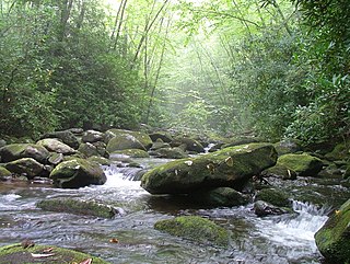
The Conasauga River is a river that runs through southeast Tennessee and northwest Georgia. The Conasauga River is 93 miles (150 km) long and is home to 90 species of fish and 25 species of freshwater mussels. The Conasauga River watershed encompasses over 500,000 acres (2,000 km2) in two states, multiple counties, and two ecologically different regions.

The Au Sable State Forest is a state forest in the north-central Lower Peninsula of Michigan. It is operated by the Michigan Department of Natural Resources.

The Conasauga logperch is a species of fish in the family Percidae. It is endemic to the United States. It is one of 184 species of darters in North America. It has been listed as endangered throughout its range with critical habitat since August 5, 1985.

Lake Conasauga is a 19-acre (77,000 m2) lake in the Lake Conasauga Campground located near the summit of Grassy Mountain in the Chattahoochee National Forest in northern Georgia, United States. It is the highest lake in Georgia at 3,150 feet (960 m) above sea level. It was built by the Civilian Conservation Corps, which finished it in 1940. "Conasauga" is a name derived from the Cherokee language meaning "grass".

The Pocket is a basin in northern Floyd County, Georgia. The valley was named as such due to how Horn Mountain curved in a way that it formed a pocket.

Conasauga is an unincorporated community in southern Polk County, Tennessee, United States. It is located approximately 1.2 miles north of the Tennessee-Georgia state line and roughly 17 miles southeast of Cleveland. The Conasauga River Lumber Company is located at Conasauga.


