
Long County is a county located in the U.S. state of Georgia. The county seat is Ludowici. Long County is part of the Hinesville-Fort Stewart Metropolitan Statistical Area. The constitutional amendment to create the county was proposed August 14, 1920, and ratified November 2, 1920. The county is named after Crawford Long (1815–1878), an American surgeon and pharmacist who was the first to use diethyl ether as an anaesthetic.

Chatham County is the easternmost county in the U.S. state of Georgia, on the state's Atlantic coast. The county seat and largest city is Savannah. One of the original counties of Georgia, Chatham County was created February 5, 1777, and is named after William Pitt, 1st Earl of Chatham.
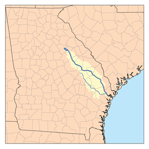
The Canoochee River is a 108-mile-long (174 km) river in southeastern Georgia in the United States. It is a tributary of the Ogeechee River, which flows to the Atlantic Ocean. In 1738 the Trustees of the colony mentioned the proposed house and ferry boat over the 'Cooanoochi River'.

The Little River is a 29.3-mile-long (47.2 km) tributary of the Etowah River in the U.S. state of Georgia in the United States.
The Alapahoochee River is a 14.4-mile-long (23.2 km) tributary of the Alapaha River in Georgia and Florida in the United States. Via the Alapaha and Suwannee rivers, its waters flow to the Gulf of Mexico.

Brier Creek or Briar Creek is a 123-mile-long (198 km) tributary of the Savannah River in the U.S. state of Georgia. It rises in Warren County east of Camak and flows southeast to the Savannah River in Screven County, 12 miles (19 km) east of Sylvania.
The Buffalo River is a 4.5-mile-long (7.2 km) tidal river northwest of Brunswick, Georgia. It is part of the Brunswick River network of tidal channels along the Atlantic coast of the U.S. state of Georgia.
The Bull River is an 8.1-mile-long (13.0 km) tidal river in the U.S. state of Georgia, running through Chatham County east of Savannah. At its north end it connects via St. Augustine Creek and the Wilmington River with the Savannah River. Its south end is at Wassaw Sound, leading to the Atlantic Ocean. The Bull River flows between Wilmington Island to the west and McQueens Island and Little Tybee Island to the east. The river is crossed by one bridge, carrying U.S. Route 80 between the communities of Wilmington Island and Tybee Island.
The Crescent River is a 5.4-mile-long (8.7 km) tidal river in McIntosh County, Georgia, in the United States. It forms in salt marshes east of the community of Bellville Point and flows southeast, ending at a river junction where the Mud River flows northeast into Sapelo Sound and Old Teakettle Creek flows south to Doboy Sound.
The Halfmoon River is a 4.6-mile-long (7.4 km) tidal river in the U.S. state of Georgia. It flows through saltmarshes connected to Wilmington Island in Chatham County, ending at Wassaw Sound, an arm of the Atlantic Ocean.
There are two streams named the Little Ochlockonee River in southern Georgia in the United States. Both are tributaries of the Ochlockonee River.

The Little Ogeechee River in Hancock County is one of two rivers with that name in the U.S. state of Georgia. It rises in Hancock County northeast of Sparta and flows southeast into Washington County, passing through Hamburgh State Park and entering the Ogeechee River 3 miles (5 km) southwest of Mitchell. The river is 21.3 miles (34.3 km) long.

The Little Satilla River is a 28.4-mile-long (45.7 km) freshwater tributary of the Satilla River in the U.S. state of Georgia. It should not be confused with the tidal Little Satilla River that is 20 miles (32 km) to the southeast and is an inlet of the Atlantic Ocean.
The Medway River is an 11.0-mile-long (17.7 km) tidal river in the U.S. state of Georgia. It is formed by the confluence of the Laurel View River with the smaller Belfast and Tivoli rivers, all three of which are tidal. It empties into St. Catherines Sound, an arm of the Atlantic Ocean. The Medway River for nearly its entire length serves as the boundary between Bryan and Liberty counties, with Chatham County joining on the north side at the river's mouth.
Rocky Comfort Creek is a 62.4-mile-long (100.4 km) tributary of the Ogeechee River in the U.S. state of Georgia. Rising in Warren County 9 miles (14 km) northwest of Warrenton, it flows southeast, entering Glascock County and passing the town of Gibson, then continuing south into Jefferson County, where it reaches the Ogeechee River at Louisville.

The Skidaway River is an 8.4-mile-long (13.5 km) tidal river in the U.S. state of Georgia. It is located in Chatham County southeast of Savannah. Its north end is at the Wilmington River, and it flows southwest from there through Skidaway Narrows to end at the Burnside River, which connects via the Vernon and Little Ogeechee rivers with Ossabaw Sound, an arm of the Atlantic Ocean. The Skidaway River flows between Skidaway Island to the east and Dutch Island and Isle of Hope to the west. It is part of the Atlantic Intracoastal Waterway.
The Tivoli River is an 8.9-mile-long (14.3 km) primarily tidal river in Bryan County, Georgia, in the United States. It flows into the Belfast River, just north of that river's terminus at the Medway River, an arm of the Atlantic Ocean.

The Turtle River is a 17.6-mile-long (28.3 km) tidal river in the vicinity of Brunswick in Glynn County, Georgia. It is the main tributary of the Brunswick River.
The Vernon River is a 12.4-mile-long (20.0 km) primarily tidal river in the U.S. state of Georgia. Located in Chatham County, it rises south of Hunter Army Airfield in Savannah and flows south into tidal marshes, where it joins the Little Ogeechee River southwest of Skidaway Island.
The Williamson Swamp Creek is a 52.4-mile-long (84.3 km) tributary of the Ogeechee River in the U.S. state of Georgia. Rising in northwestern Washington County 12 miles (19 km) north of Sandersville, it flows southeast past Davisboro and enters Jefferson County, ending at the Ogeechee River 5 miles (8 km) southeast of Wadley.
