Columbia County is a county located in the east central portion of the US state of Georgia. As of the 2010 census, the population was 124,035. The legal county seat is Appling, but the de facto seat of county government is Evans.
Evans is a census-designated place (CDP) in Columbia County, Georgia, United States. It is a suburb of Augusta and is part of the Augusta metropolitan area. The population was 29,011 at the 2010 census, up from 17,727 at the 2000 census.

Grovetown is a city in Columbia County, Georgia, United States. It is part of the Augusta metropolitan area and the Central Savannah River Area. The 2019 population estimate was 15,152. The mayor is Gary Jones.

The Shenandoah River is a tributary of the Potomac River, 55.6 miles (89.5 km) long with two forks approximately 100 miles (160 km) long each, in the U.S. states of Virginia and West Virginia. The principal tributary of the Potomac, the river and its tributaries drain the central and lower Shenandoah Valley and the Page Valley in the Appalachians on the west side of the Blue Ridge Mountains, in northwestern Virginia and the Eastern Panhandle of West Virginia.

State Route 38 is a mostly rural and scenic state highway in the U.S. state of California, connecting Interstate 10 in Redlands with State Route 18 in the Big Bear Lake area. It is one of the primary routes into the San Bernardino Mountains. Despite the orientation of its alignment, SR 38 is assigned in a west–east direction.

The Yuchi people, also spelled Euchee and Uchee, are a Native American tribe who historically lived in the eastern Tennessee River valley in Tennessee in the 16th century. In the late 17th century, they moved south to Alabama, Georgia, and South Carolina, settling near the Creek people. Some also migrated to the panhandle of Florida. After suffering many fatalities from epidemic disease and warfare in the 18th century, several surviving Yuchi bands were removed to Indian Territory in the 1830s, together with their allies the Muscogee Creek.
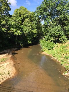
Peachtree Creek is a major stream in Atlanta. It flows for 7.5 miles (12.1 km) almost due west into the Chattahoochee River just south of Vinings.

State Route 10 (SR 10) is a 172.3-mile-long (277.3 km) state highway in the U.S. state of Georgia. It travels from Downtown Atlanta to the South Carolina state line in Augusta. This highway, along with U.S. Route 78 (US 78), connect three of the biggest metro areas of the state together: Atlanta, Athens, and Augusta. It travels concurrently with US 78 in three sections: from Atlanta to Druid Hills; from near Stone Mountain to near Athens; and from Athens to its eastern terminus, for a total of 149.2 miles (240.1 km), or approximately 86.6 percent of its route.
The Fall Line Freeway is a 215-mile-long (346 km) highway designed to span the width of the U.S. state of Georgia from Columbus at the Alabama state line to Augusta, traveling through several cities including Macon, Fort Valley, Sandersville, and Wrens. Though it is called a freeway, it is composed of both limited-access and high-speed divided highway portions. There are also two segments of the highway that are two lanes, separated by a center turn lane: a brief portion in west-central Washington County and another brief portion in northern Jefferson County. As of August 2018, the Fall Line Freeway is 100% open to traffic. Between August 2017 and July 2018, the highway was completed. The Georgia Department of Transportation (GDOT) announced that the highway was officially signed as SR 540 on September 24, 2018.

State Route 4 (SR 4) is a state highway in the eastern part of the U.S. state of Georgia. Except for its northernmost portion, it is completely concurrent for its entire length with U.S. Route 1 (US 1). It traverses south-to-north through portions of Charlton, Ware, Bacon, Appling, Toombs, Emanuel, Jefferson, and Richmond counties in the southeastern and east-central parts of the state. The highway begins at the Florida state line, on US 1/US 23/US 301/SR 15 at the St. Marys River, where SR 15 also reaches its southern terminus. It travels to its northern terminus at the South Carolina state line, on the Augusta–North Augusta, South Carolina city line, on US 25 Business at the Savannah River.

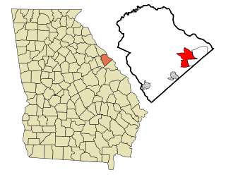
State Route 388 (SR 388) is a 4.5-mile-long (7.2 km) state highway that travels south-to-north in a backward L-shape, completely within Columbia County, in the east-central part of the state of Georgia. It connects Grovetown to Lewiston.
In the U.S. state of Georgia, Interstate 20 (I-20) travels from the Alabama state line to the Savannah River, which is the South Carolina state line. The highway enters the state near Tallapoosa. It travels through the Atlanta metropolitan area and exits the state in Augusta. The highway also travels through the cities of Bremen, Douglasville, Conyers, Covington, and Madison. I-20 has the unsigned state highway designation of State Route 402 (SR 402).

State Route 232 (SR 232) is a 14.3-mile-long (23.0 km) east–west state highway located in the east-central part of the U.S. state of Georgia. It travels through west-central Columbia County and northeastern Richmond County. At its western end, it is a fairly rural highway, but its eastern end is an urban corridor of the Augusta metropolitan area. It connects Appling with Evans, Martinez, and Augusta.
U.S. Route 78 (US 78) is a 233.3-mile-long (375.5 km) U.S. Highway in the U.S. state of Georgia. It travels west to east in the north-central part of the state, starting at the Alabama state line, west of Tallapoosa, where the roadway continues concurrent with the unsigned highway Alabama State Route 4. This is also the western terminus of Georgia State Route 8 (SR 8), which is concurrent with US 78 to the east. The highway serves the Atlanta, Athens, and Augusta metropolitan areas on its path from the Alabama state line to the South Carolina state line, at the Savannah River, on the northeastern edge of Augusta, where it continues concurrent with US 1/US 25/US 278/SC 121. This is also the eastern terminus of SR 10 and the northern terminus of SR 121, as well as the southern terminus of SC 121. US 78 travels through portions of Haralson, Carroll, Douglas, Cobb, Fulton, DeKalb, Gwinnett, Walton, Oconee, Clarke, Oglethorpe, Wilkes, McDuffie, Columbia, and Richmond counties.
U.S. Route 278 (US 278) in the U.S. state of Georgia is an east–west United States Highway traversing the north-central portion of the state. The highway travels from its western terminus as US 278/SR 74 at the Alabama state line near Esom Hill to its eastern terminus at US 1/US 25/US 78/US 278/SC 121 in the Augusta metropolitan area where it crosses the Savannah River into South Carolina.
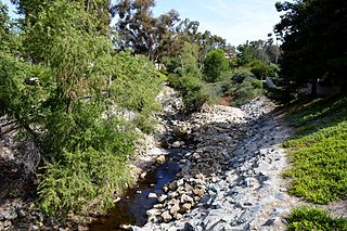
Oso Creek is an approximately 13.5-mile (21.7 km) tributary of Arroyo Trabuco in southern Orange County in the U.S. state of California. Draining about 20 square miles (52 km2) in a region north of the San Joaquin Hills and south of the Santa Ana Mountains, the creek is Trabuco Creek's largest tributary, and is part of the San Juan Creek drainage basin. Beginning in the foothills of the Santa Ana Mountains near the city of Mission Viejo, the creek is dammed twice to form Upper Oso Reservoir and Lake Mission Viejo. The creek is channelized and polluted along much of its length.
The Columbia County School System is a school district based in Columbia County, Georgia, United States. It is run by the Columbia County Board of Education with superintendent Dr. Sandra Carraway. CCSS currently operates a total of 32 schools: 18 elementary schools, eight middle schools, five high schools, and an alternative school.
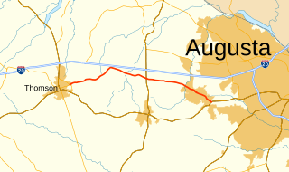
State Route 223 (SR 223) is a 20.9-mile-long (33.6 km) east–west state highway in the east-central part of the U.S. state of Georgia. Its routing travels through portions of McDuffie, Columbia, and Richmond counties. The highway connects Thomson with Grovetown, Augusta, and Fort Gordon. Except for the portions in Thomson, Grovetown, and Augusta, the highway is relatively rural.
Wrightsboro Road is a 45.0-mile-long (72.4 km) major road in the east-central part of the U.S. state of Georgia, traveling through the northwestern part of McDuffie County, the extreme northern part of Warren County, the southeastern part of Wilkes County, the southern part of Columbia County, and the northeastern part of Richmond County.
The Greater Clarks Hill Regional Library System (GCHRL) is a consortium of eight public libraries working together to serve the populations of Columbia, Burke, Lincoln, and Warren counties in east Georgia.