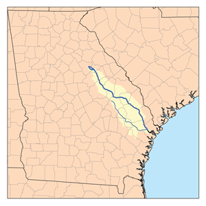
The Canoochee River is a 108-mile-long (174 km) river in southeastern Georgia in the United States. It is a tributary of the Ogeechee River, which flows to the Atlantic Ocean. In 1738 the Trustees of the colony mentioned the proposed house and ferry boat over the 'Cooanoochi River'.

The Brunswick River is a 6-mile-long (10 km) tidal river in Georgia. It begins at the Sidney Lanier Bridge at Brunswick, Georgia, at the confluence of the Turtle River with the East River, and flows east to St. Simons Sound, the strait between Saint Simons Island to the north and Jekyll Island to the south.
The Crescent River is a 5.4-mile-long (8.7 km) tidal river in McIntosh County, Georgia, in the United States. It forms in salt marshes east of the community of Bellville Point and flows southeast, ending at a river junction where the Mud River flows northeast into Sapelo Sound and Old Teakettle Creek flows south to Doboy Sound.
The Crooked River is a 26.8-mile-long (43.1 km) river in Camden County in the U.S. state of Georgia. Primarily tidal, it is an inlet of Cumberland Sound.

The Duplin River is an 8.1-mile-long (13.0 km) tidal river in McIntosh County, Georgia, in the United States. It flows from north to south along the western edge of Sapelo Island into Doboy Sound, an arm of the Atlantic Ocean.
The Halfmoon River is a 4.6-mile-long (7.4 km) tidal river in the U.S. state of Georgia. It flows through saltmarshes connected to Wilmington Island in Chatham County, ending at Wassaw Sound, an arm of the Atlantic Ocean.
The Hampton River is a 12.3-mile-long (19.8 km) tidal river in Glynn County, Georgia. It forms a channel between Saint Simons Island and Little Saint Simons Island on the Atlantic coast.
The Jerico River is a 12.8-mile-long (20.6 km) river on the Atlantic coastal plain in the U.S. state of Georgia. It serves as the boundary between Bryan and Liberty counties for its entire length.
The Laurel View River is a 4.6-mile-long (7.4 km) tidal river in the U.S. state of Georgia. It is fed by the Jerico River, which splits into the Laurel View and Belfast rivers, and ends where the Belfast River rejoins it, forming the Medway River, which continues to the Atlantic Ocean. For its entire length, the Laurel View River forms the boundary between Bryan and Liberty counties.
The Little Ogeechee River in Chatham County is one of two rivers by that name in the U.S. state of Georgia. Rising in southern Effingham County, the Little Ogeechee flows to the southeast and enters Chatham County, where it becomes tidal in the vicinity of its crossing by U.S. Route 17. From that point, the river flows through salt marshes and widens considerably, crossing under Georgia State Route 204 west of the Windsor Forest section of Savannah, and ending at Ossabaw Sound just north of the mouth of the Ogeechee River. The entire Little Ogeechee River is 42.8 miles (68.9 km) long.

The Little Satilla River is a 28.4-mile-long (45.7 km) freshwater tributary of the Satilla River in the U.S. state of Georgia. It should not be confused with the tidal Little Satilla River that is 20 miles (32 km) to the southeast and is an inlet of the Atlantic Ocean.
The Mackay River is a 13.4-mile-long (21.6 km) tidal river in Glynn County, Georgia. It flows between Saint Simons Island to the east and the mainland, including the city of Brunswick, to the west, and connects to Buttermilk Sound at its north end and St. Simons Sound and the Brunswick River at its south end. It runs parallel to and west of the Frederica River. The Mackay River is crossed by the F.J. Torras Causeway traveling between Brunswick and Saint Simons. It is part of the Intracoastal Waterway.
The North Newport River is a 26-mile-long (42 km) tidal river in Liberty County in the U.S. state of Georgia. It rises just west of Interstate 95, 15 miles (24 km) south of Richmond Hill, and flows generally east-southeast to its mouth at the Medway River and St. Catherines Sound on the Atlantic Ocean.
The Odingsell River is a 5.7-mile-long (9.2 km) tidal river in the U.S. state of Georgia. It flows into Ossabaw Sound just north of the mouth of the Ogeechee River. It passes through salt marshes lying between Skidaway Island to the west, Wassaw Island to the north and east, and Little Wassaw Island to the south.
The Sapelo River is a 23-mile-long (37 km) primarily tidal river in McIntosh County in the U.S. state of Georgia. It forms between Interstate 95 and U.S. Route 17 near the community of Eulonia and winds generally east through salt marshes into Sapelo Sound, an arm of the Atlantic Ocean that separates St. Catherines Island to the north from Sapelo Island to the south.

The Skidaway River is an 8.4-mile-long (13.5 km) tidal river in the U.S. state of Georgia. It is located in Chatham County southeast of Savannah. Its north end is at the Wilmington River, and it flows southwest from there through Skidaway Narrows to end at the Burnside River, which connects via the Vernon and Little Ogeechee rivers with Ossabaw Sound, an arm of the Atlantic Ocean. The Skidaway River flows between Skidaway Island to the east and Dutch Island and Isle of Hope to the west. It is part of the Atlantic Intracoastal Waterway.
The South River is a 3.2-mile-long (5.1 km) tidal channel in McIntosh County, Georgia, in the United States. It connects the Darien River to its west with Doboy Sound, an arm of the Atlantic Ocean, to its east. It flows through an extensive saltmarsh complex, with Queens Island to the north and Wolf Island to the south.
The Tivoli River is an 8.9-mile-long (14.3 km) primarily tidal river in Bryan County, Georgia, in the United States. It flows into the Belfast River, just north of that river's terminus at the Medway River, an arm of the Atlantic Ocean.
The Vernon River is a 12.4-mile-long (20.0 km) primarily tidal river in the U.S. state of Georgia. Located in Chatham County, it rises south of Hunter Army Airfield in Savannah and flows south into tidal marshes, where it joins the Little Ogeechee River southwest of Skidaway Island.

The Willacoochee River is a 21.5-mile-long (34.6 km) tributary of the Alapaha River in the U.S. state of Georgia. Via the Alapaha and Suwannee rivers, its waters flow to the Gulf of Mexico.


