Related Research Articles

The Black River is a tributary of the Cape Fear River, approximately 50 mi (80 km) long, in southeastern North Carolina in the United States.

The Napa River is a river approximately 55 miles (89 km) long in the U.S. state of California. It drains a famous wine-growing region called the Napa Valley, in the mountains north of the San Francisco Bay. Milliken Creek and Mt. Veeder watersheds are a few of its many tributaries. The river mouth is at Vallejo, where the intertidal zone of fresh and salt waters flow into the Carquinez Strait and the San Pablo Bay.

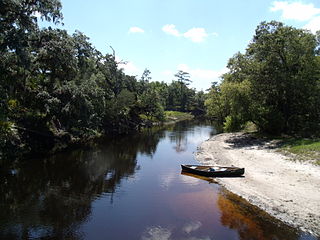
A blackwater river is a type of river with a slow-moving channel flowing through forested swamps or wetlands. Most major blackwater rivers are in the Amazon Basin and the Southern United States. The term is used in fluvial studies, geology, geography, ecology, and biology. Not all dark rivers are blackwater in that technical sense. Some rivers in temperate regions, which drain or flow through areas of dark black loam, are simply black due to the color of the soil; these rivers are black mud rivers. There are also black mud estuaries.

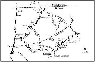
The Satilla River rises in Ben Hill County, Georgia, United States, near the town of Fitzgerald, and flows in a mostly easterly direction to the Atlantic Ocean. Along its approximately 235-mile (378 km) course are the cities of Waycross, Waynesville, and Woodbine. The Satilla drains almost 4,000 square miles (10,000 km2) of land, all of it in the coastal plain of southeastern Georgia. It has white sandbars and is the largest blackwater river situated entirely within Georgia. The Satilla enters the Atlantic Ocean about 10 miles (16 km) south of Brunswick, at the 31st parallel north. Satilla River Marsh Island The river derives its name from a Spanish officer named Saint Illa, and over time the name was corrupted to form the word Satilla. French explorer Jean Ribault named the river the Somme when he encountered it in 1562. The river was later given the name Aisne by Jacques le Moyne.

The 74-mile-long (119 km) Ocklawaha River flows north from central Florida until it joins the St. Johns River near Palatka. Its name is derived from ak-lowahe, Creek for "muddy".

Lower Wekiva River Preserve State Park is an 18,000-acre (7,300 ha) Florida State Park located on six miles (10 km) of the St. Johns River in Lake and Seminole counties. The park forms a wildlife corridor to the Ocala National Forest along the Wekiva and St. Johns Rivers.
Rock Springs Run State Reserve is a 14,000-acre (5,700 ha) State Park in the U.S. state of Florida. The main entrance is located about 30 miles (48 km) north of Orlando in Sorrento, 3 miles (4.8 km) west of the Wekiva River bridge on State Road 46 and extends into Orange and Seminole Counties to the south. The park contains a number of Indian mounds, pine flatwoods, swamps and artesian springs, and a number of creeks and rivers. Among them are Seminole Creek, Wekiwa Springs Run, Rock Springs Run, and the Wekiva River.

Wekiwa Springs State Park is a 7,000-acre (28 km2) Florida State Park in Apopka, Florida. It is located 20 minutes north of Orlando, off Interstate 4 at exit 94, near Altamonte Springs and Longwood. The park also contains the head water of the Wekiva River. It also serves as the headquarters of one of the state's five AmeriCorps Florida State Parks chapters.
The Bartram Trail follows the approximate route of 18th-century naturalist William Bartram’s southern journey from March 1773 to January 1777. Bartram explored much of the territory which is now the states of North and South Carolina, Georgia, Florida, Alabama, Mississippi, Louisiana and Tennessee.
Bobs Creek is a tributary of Dunning Creek in south west/south central Pennsylvania in the United States.

The Waccasassa River is a small, isolated river in Levy County, Florida, flowing through the Gulf Hammock wetlands and emptying into the Gulf of Mexico. The river is 29 miles (47 km) long, and has a drainage basin of 610 square miles (1,600 km2). Three-quarters of the river is accessible only by canoe or kayak.

The Blackwater River of Florida is a 56.6-mile-long (91.1 km) river rising in southern Alabama and flowing through the Florida Panhandle to the Gulf of Mexico. The river enters Florida in Okaloosa County and flows through Santa Rosa County to Blackwater Bay, an arm of Pensacola Bay. The river passes through Blackwater River State Forest and Blackwater River State Park. Milton, the county seat of Santa Rosa County, is located on the river.
The Wekiva River is a 16.0-mile-long (25.7 km) river in Central Florida, north of Orlando in the United States. It originates in Apopka and joins the St. Johns River, the longest river in the state, in DeBary. The Wekiva River system includes the main stem joined by three main tributaries - Rock Springs Run, Blackwater Creek, and the Little Wekiva River - and about 30 contributing groundwater springs. It is designated as a Florida State Canoe Trail, an Outstanding Florida Water, and an Aquatic Preserve by the Florida Department of Environmental Protection. The Wekiva River system is also one of the two rivers in Florida federally designated as a National Wild and Scenic River for its scenery, recreation, geology, and diverse habitats.

The Pithlachascotee River, often called the Cotee or "Cootie" River, is a blackwater river in Pasco County, Florida.
The Econlockhatchee River is an 54.5-mile-long (87.7 km) north-flowing blackwater tributary of the St. Johns River. The Econ River flows through Osceola, Orange, and Seminole counties in Central Florida, just east of the Orlando Metropolitan Area. It is a designated Outstanding Florida Waters.

The Loxahatchee River is a 7.6 mile river near the southeast coast of Florida. It is a National Wild and Scenic River, one of only two in the state, and received its federal designation on May 17, 1985. The source of the Loxahatchee River is in Riverbend Park on the south side of Indiantown Road about 1.5 miles west of I-95 and Florida's Turnpike in Jupiter, Florida. The Loxahatchee River flows out of the Jupiter Inlet and into the Atlantic Ocean. This river was the inspiration for Florida film producer Elam Stoltzfus' 2005 project Our Signature: the Wild and Scenic Loxahatchee River, a film done in conjunction with the Loxahatchee River Preservation Initiative.

Black Creek is a tributary of the St. Johns River in Clay County, Florida. It is formed by the confluence of North Fork Black Creek and South Fork Black Creek. North Fork Black Creek originates as an outflow from Kingsley Lake and flows north and then southeast, meeting South Fork Black Creek on the east side of MIddleburg. North Fork Black Creek has Yellow Water Creek as its main tributary. South Fork Black Creek originates in a chain of lakes about four miles south of Kingsley Lake, with Ates Creek, Bull Creek, and Greens Creek as its main tributaries. Both forks are fed by areas of wetlands and numerous small streams.
The Palatlakaha River is a river in Lake County, Florida. It forms the principal headwater of the Ocklawaha River, a tributary of St. Johns River. The source of the Palatlakaha River is at Lake Louisa, itself fed from the Green Swamp by two streams known as Big Creek and Little Creek.
The Wekiva River, also known as Wekiva Creek or Wekiva Run, is a tributary of the Waccasassa River in Levy County, Florida that originates at Wekiva Spring. From the spring the river meanders westward and then southward about 7 miles (11 km) to where it flows into the Waccasassa River. It is fed along the way by Mule Creek and the Little Wekiva River. The river is centrally located in the area between the Withlacoochee and Suwannee Rivers that is often referred to as the Gulf Hammock.
References
- ↑ Blackwater Creek (BWC44) Watershed facts St John's River Water Management District
- ↑ Robison, J.; Belleville, B. (2009). Along the Wekiva River. Arcadia Pub. p. 9. ISBN 9780738566023 . Retrieved 2015-07-05.
- ↑ Molloy, J.; Carter, E.; Pearce, J. (2011). Canoeing and Kayaking Florida. Menasha Ridge Press, Incorporated. ISBN 9780897327671 . Retrieved 2015-07-05.
- ↑ Along The Wekiva River page 9
28°51′40″N81°23′09″W / 28.861103°N 81.385957°W