
DeBary is a city in Volusia County, Florida, United States, on the eastern shore of the St. Johns River near Lake Monroe. According to the 2020 U.S. Census, the city had a population of 20,696. It is part of the Deltona–Daytona Beach–Ormond Beach, FL metropolitan statistical area, which was home to 553,284 people in 2019.

The Second Seminole War, also known as the Florida War, was a conflict from 1835 to 1842 in Florida between the United States and groups of people collectively known as Seminoles, consisting of Native Americans and Black Indians. It was part of a series of conflicts called the Seminole Wars. The Second Seminole War, often referred to as the Seminole War, is regarded as "the longest and most costly of the Indian conflicts of the United States". After the Treaty of Payne's Landing in 1832 that called for the Seminole's removal from Florida, tensions rose until fierce hostilities occurred in the Dade battle in 1835. This conflict started the war. The Seminoles and the U.S. forces engaged in mostly small engagements for more than six years. By 1842, only a few hundred native peoples remained in Florida. Although no peace treaty was ever signed, the war was declared over on August 14, 1842.

The St. Johns River is the longest river in the U.S. state of Florida and it is the most significant one for commercial and recreational use. At 310 miles (500 km) long, it flows north and winds through or borders twelve counties. The drop in elevation from headwaters to mouth is less than 30 feet (9 m); like most Florida waterways, the St. Johns has a very slow flow speed of 0.3 mph (0.13 m/s), and is often described as "lazy".

William Selby Harney, otherwise known as Woman Killer, was a Tennessee-born cavalry officer in the US Army, who became known during the Indian Wars and the Mexican–American War for his brutality and ruthlessness. One of four general officers in the US Army at the beginning of the American Civil War, he was removed from overseeing the Department of the West because of his Southern sympathies early in the war, although he kept Missouri from joining the Confederacy. Under President Andrew Johnson, he served on the Indian Peace Commission, negotiating several treaties before spending his retirement partly in St. Louis and partly trading reminiscences with Jefferson Davis and Ulysses S. Grant in Mississippi.

City Island, Daytona Beach, Florida, United States, is an island in the Halifax River between mainland Florida and the barrier islands/outer banks. Buildings on the island include the Daytona Tortugas' Jackie Robinson Ballpark, the city's courthouse, and the main branch of the Volusia County Library.
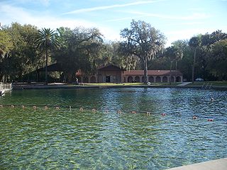
De Leon Springs State Park is a Florida State Park in Volusia County, Florida. It is located in DeLeon Springs, off CR 3.

The Lower Suwannee National Wildlife Refuge (LSNWR) is part of the United States National Wildlife Refuge System. It is located in southeastern Dixie and northwestern Levy counties on the western coast of Florida, approximately fifty miles southwest of the city of Gainesville.

Zippel Bay State Park is a state park in Lake of the Woods County, Minnesota in the United States. It is on the white sand beach shoreline of the Lake of the Woods, near the United States border with Canada. The park is open for year-round recreation including camping, hiking, fishing and cross-country skiing.

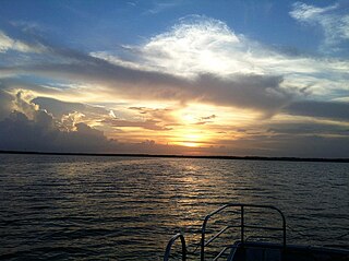
The Halifax River is part of the Atlantic Intracoastal Waterway, located in northeast Volusia County, Florida. The waterway was originally known as the North Mosquito River, but was renamed after George Montagu-Dunk, 2nd Earl of Halifax, during the British occupation of Florida (1763–1784).

St. Vincent Island is the westernmost of 4 barrier islands in the northwestern Florida Gulf coast which include Cape St. George Island, St. George Island and Dog Island. The island is located just offshore in Franklin County, Florida south southeast of Cape San Blas and north of Cape St. George Island close to the mouth of the Apalachicola River and the town of Apalachicola on the Florida Panhandle.

Tomoka State Park is an 2,000-acre (8.1 km2) Florida State Park located along the Tomoka River, three miles (5 km) north of Ormond Beach on North Beach Street.

The Florida Trail is one of eleven National Scenic Trails in the United States. It currently runs 1,500 miles (2,400 km), from Big Cypress National Preserve to Fort Pickens at Gulf Islands National Seashore, Pensacola Beach. Also known as the Florida National Scenic Trail, the Florida Trail provides permanent non-motorized recreation opportunity for hiking and other compatible activities and is within an hour of most Floridians. The Florida National Scenic Trail is designated as a National Scenic Trail by the National Trails System Act of 1968.

Enterprise is an unincorporated community in Volusia County, in the U.S. state of Florida, and its former county seat. Situated on the northern shore of Lake Monroe, it is flanked by the cities of DeBary and Deltona. Enterprise was once the head of navigation on the St. Johns River and at various times, the county seat for three different counties: Mosquito, which was renamed as Orange; and lastly, for Volusia, which was formed from part of Orange County.
The Manatee River is a 36-mile-long (58 km) river in Manatee County, Florida. The river forms in the northeastern corner of Manatee County and flows into the Gulf of Mexico at the southern edge of Tampa Bay.
Puzzle Lake is a lake near Geneva in Seminole County, Florida. It forms the border of Volusia and Seminole counties. It is one of the lakes that make up the St. Johns River system. 1,627 yards (1,488 m) north of the lake is the mouth of the tributary, the Econlockhatchee River. It has a surface area of 1,300 acres (530 ha). 3.2 miles (5.1 km) downriver is Lake Harney, the start of the river becoming a wetland (upriver). It will become a narrow river again past Lake Poinsett in Brevard County. The lake is named after this because the navigable portions of the lake change seasonally depending on the amount of rainfall. When the waters recede, previously known boat routes can be hindered by new, submersed, sandbars and deep water channels that are completely different from the year before.

The Lake George State Forest is a designated protected area and state forest in the U.S. state of Florida. The 21,176-acre (8,570 ha) forest is located in northwestern Volusia County, Florida, near Lake George and the communities of Pierson, Barberville, and Volusia. It is overseen by the Florida Forest Service within the Florida Department of Agriculture and Consumer Services.

The Wacissa River is a large, spring-fed stream located in south-central Jefferson County, Florida. Its headwaters are located about a mile south of the town of Wacissa, where the river emerges crystal clear from a group of large limestone springs. From its headsprings, the river flows approximately 12 miles (19 km) south through a broad cypress swamp before breaking into numerous braided channels which join the Aucilla River a few miles further south. The river is managed by the Florida Fish & Wildlife Conservation Commission as part of the Aucilla Wildlife Management Area, and has been declared an Outstanding Florida Waterway by the Florida Department of Environmental Protection.
Lake Jesup is the largest lake in Seminole County, Florida, United States and is one of many that make up the St. Johns River. Located along the middle basin of the St. Johns, the lake encompasses an area of approximately 16,000 acres (65 km2), including open water and floodplain. It is named in honor of Brigadier General Thomas Jesup, an American military officer who served in the Second Seminole War. The lake is bisected by one of the state's longest free-standing bridges, part of the Seminole County Expressway.
Pennichaw is a rural unincorporated community located in south Volusia County, Florida, United States. It located on Lake Harney Road, approximately 1.8 miles south of Maytown Road.

Fort Caben was a Second Seminole War fort in Flagler County, Florida. In 1958, a report listing Flagler County historical sites, compiled for Florida Governor Thomas LeRoy Collins (1909–1991) and the State Park Board, stated, "'Fort Caben' was built for defense against the Indians – about 1834. No trace left. [It was] probably a wood building. Location: Section 38, Township 13 – South, Range 29 East, on Fish Hawk Point."

