
Boca Raton is a city in Palm Beach County, Florida, United States. The population was 97,422 in the 2020 census and it ranked as the 23rd-largest city in Florida in 2022. However, many people with a Boca Raton postal address live outside of municipal boundaries, such as in West Boca Raton. As a business center, the city also experiences significant daytime population increases. Boca Raton is 45 miles (72 km) north of Miami and is a principal city of the Miami metropolitan area, which had a population of 6,138,333 at the 2020 United States Census.
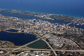
Palm Beach County is a county in the southeastern part of Florida, located in the Miami metropolitan area. It is Florida's third-most populous county after Miami-Dade County and Broward County and the 26th-most populous in the United States, with 1,492,191 residents as of the 2020 census. Its county seat and largest city is West Palm Beach, which had a population of 117,415 as of 2020. Named after one of its oldest settlements, Palm Beach, the county was established in 1909, after being split from Miami-Dade County. The county's modern-day boundaries were established in 1963.

The Everglades is a natural region of flooded grasslands in the southern portion of the U.S. state of Florida, comprising the southern half of a large drainage basin within the Neotropical realm. The system begins near Orlando with the Kissimmee River, which discharges into the vast but shallow Lake Okeechobee. Water leaving the lake in the wet season forms a slow-moving river 60 miles (97 km) wide and over 100 miles (160 km) long, flowing southward across a limestone shelf to Florida Bay at the southern end of the state. The Everglades experiences a wide range of weather patterns, from frequent flooding in the wet season to drought in the dry season. Throughout the 20th century, the Everglades suffered significant loss of habitat and environmental degradation.
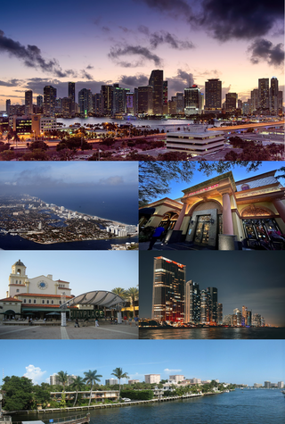
The Miami metropolitan area is a coastal metropolitan area in southeastern Florida. It is the ninth-largest metropolitan statistical area (MSA) in the United States, the fifth-largest metropolitan area in the Southern United States, and the largest metropolitan area in Florida. It is also known as South Florida, SoFlo, SoFla, the Gold Coast, Southeast Florida, the Tri-County Area, or Greater Miami, and officially as the Miami–Fort Lauderdale–West Palm Beach Metropolitan Statistical Area. With a population of 6.18 million, its population exceeds 31 of the nation's 50 states as of 2023. It comprises the three most populated counties in the state, Miami-Dade County, Broward County, and Palm Beach County, which rank as the first, second, and third-most populous counties in the state, respectively. Miami-Dade County, with 2,701,767 people in 2020, is the seventh-most populous county in the United States.

The Arthur R. Marshall Loxahatchee National Wildlife Refuge is a 145,188-acre (587.55 km2) wildlife sanctuary is located west of Boynton Beach, in Palm Beach County, Florida. It is also known as Water Conservation Area 1 (WCA-1). It includes the most northern remnant of the historic Everglades wetland ecosystem.

The 1947 Fort Lauderdale hurricane(Air Weather Service designation: George) was a long-lived and an intense tropical cyclone that affected the Bahamas, southernmost Florida, and the Gulf Coast of the United States in September 1947. The fourth Atlantic tropical cyclone of the year, it formed in the eastern Atlantic Ocean on September 4, becoming a hurricane, the third of the 1947 Atlantic hurricane season, less than a day later. After moving south by west for the next four days, it turned to the northwest and rapidly attained strength beginning on September 9. It reached a peak intensity of 145 mph (233 km/h) on September 15 while approaching the Bahamas. In spite of contemporaneous forecasts that predicted a strike farther north, the storm then turned to the west and poised to strike South Florida, crossing first the northern Bahamas at peak intensity. In the Bahamas, the storm produced a large storm surge and heavy damage, but with no reported fatalities.

Military Trail is a 46.2-mile (74.35 km) long six-lane north–south arterial road in Broward and Palm Beach counties in South Florida. A portion of the road is designated State Road 809 (SR 809), but most of the road within Palm Beach County is locally maintained and signed as County Road 809 (CR 809), while the Broward County section exists without either designation.
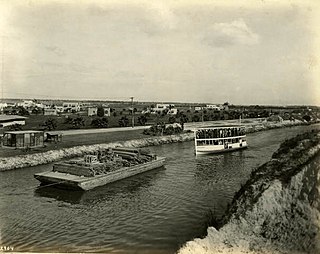
The Miami Canal, or C-6 Canal, flows from Lake Okeechobee in the U.S. state of Florida to its terminus at the Miami River, which flows through downtown Miami. The canal flows in a south and southeasterly direction for approximately 77 miles, and passes through three counties: Broward, Palm Beach, and Miami-Dade. It was constructed in the early part of the 20th century to drain the Everglades Agricultural Area (EAA). Removing the canal was proposed as part of the Restoration of the Everglades.

The Palm Beach Inlet, also known as the Lake Worth Inlet is an artificial cut through a barrier island connecting the northern part of the Lake Worth Lagoon in Palm Beach County, Florida with the Atlantic Ocean. It is bordered by the town of Palm Beach on the south, and by the town of Palm Beach Shores to the north. The inlet is also the entrance channel for the Port of Palm Beach. Its coordinates are 26°46′20″N80°02′14″W.

The former State Road 827, was an east–west road that stretched 35 miles (56 km) along the southern edge of the Hillsboro Canal, originally extending from Sixmile Bend to present-day Parkland. Now County Road 827, the road is locally known as Browns Farms Road and Loxahatchee Road in two segments, while a third is unnamed.

Loxahatchee Groves is a town in Palm Beach County, Florida, United States. The town was incorporated November 1, 2006, as the 38th municipality in Palm Beach County. The first election for town council members was held on March 13, 2007. The area had been settled since 1917, although Loxahatchee Groves did not become a municipality until 2006. The town bills itself as "Florida's Last Frontier". It was incorporated primarily in order to protect the area from the encroaching urbanization of South Florida, as nearby cities continued to develop and to preserve the area's rural character. The town is part of the Miami metropolitan area. As of the 2020 US census, the town had a population of 3,355.
The South Florida Water Management District (SFWMD) is a regional governmental district that oversees water resources from Orlando to the Florida Keys. The mission of the SFWMD is to manage and protect water resources by balancing and improving water quality, flood control, natural systems, and water supply, covering 16 counties in Central and Southern Florida. It is the largest water management district in the state, managing water needs for 7.7 million residents. A key initiative is the restoration of America's Everglades – the largest environmental restoration project in the nation's history. The District is also working to improve the Kissimmee River and its floodplain, Lake Okeechobee and South Florida's coastal estuaries.

The Gumbo Limbo Environmental Complex, commonly known as the Gumbo Limbo Nature Center, is a nature center operated by the city of Boca Raton, Florida, in conjunction with the Gumbo Limbo Coastal Stewards and the Greater Boca Raton Beach and Park District, and located at 1801 N. Ocean Blvd. in Boca Raton. Gumbo Limbo sits on twenty acres of protected barrier island, the area between the Intracoastal Waterway and the Atlantic Ocean. It is on land which is part of the beachfront-to-intracoastal Red Reef Park, though Gumbo Limbo does not have land directly on the beach. Its name comes from a popular name of the Bursera simaruba tree species, which is abundant in the park.

A national push for expansion and progress toward the latter part of the 19th century stimulated interest in draining the Everglades, a region of tropical wetlands in southern Florida, for agricultural use. According to historians, "From the middle of the nineteenth century to the middle of the twentieth century, the United States went through a period in which wetland removal was not questioned. Indeed, it was considered the proper thing to do."

An ongoing effort to remedy damage inflicted during the 20th century on the Everglades, a region of tropical wetlands in southern Florida, is the most expensive and comprehensive environmental repair attempt in history. The degradation of the Everglades became an issue in the United States in the early 1970s after a proposal to construct an airport in the Big Cypress Swamp. Studies indicated the airport would have destroyed the ecosystem in South Florida and Everglades National Park. After decades of destructive practices, both state and federal agencies are looking for ways to balance the needs of the natural environment in South Florida with urban and agricultural centers that have recently and rapidly grown in and near the Everglades.

The New River is a tidal estuary in South Florida, United States. Despite its name, it is not a true natural river, but a channel composed of many tributary canals. The channel is connected to the Everglades through a series of man-made canals. After passing through Fort Lauderdale, the channel connects to the Intracoastal Waterway and Atlantic Ocean at Port Everglades cut. The channel is entirely within Broward County and is composed from the junction of three main canals which originate in the Everglades, splitting off from the Miami Canal. They are the North New River Canal, which flows south from Lake Okeechobee along the east side of U.S. 27 and then east along the north side of State Road 84 / Interstate 595; the South New River Canal, which flows east from the Miami Canal along the north side of Griffin Road and the south side of Orange Drive; and a canal which flows east along the south side of Sunrise Boulevard. The Henry E. Kinney Tunnel in downtown Fort Lauderdale travels underneath the New River.
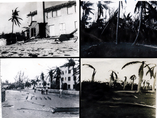
The 1947 Fort Lauderdale hurricane had widespread impacts in Florida. It produced significant flooding, damage to vegetation, and beach erosion in the Miami metropolitan area. After forming off West Africa on September 2, the storm moved on a parabolic path that brought it through The Bahamas as a Category 3 hurricane on September 16, eventually striking the city of Fort Lauderdale in South Florida as a powerful Category 4 hurricane on the following day. The hurricane later crossed the state, entered the Gulf of Mexico near Naples less than 24 hours later, and went on to strike Louisiana before dissipating on September 21.

The Spanish River is a former fresh-water stream which once flowed through Boca Raton, Florida. It was originally known, erroneously, as "Boca Raton's Lagoon" or "Lake Boca Ratones", a name first used in 1823—Boca Raton apparently having been originally appended to an inlet near Biscayne Bay—and later as the "Little Hillsboro", but settlers, supposing it to have been discovered by Spanish colonizers, renamed it the "Old Spanish River"; the last dates to 1895 or later, when the stream was progressively canalized and eventually turned into the Intracoastal Waterway. By 1945 the original contours of the stream effectively vanished, save for remnants.
Palm Beach County is a county in the southeastern part of the U.S. state of Florida. Its history dates back to about 12,000 years ago, shortly after when Native Americans migrated into Florida. Juan Ponce de León became the first European in the area, landing at the Jupiter Inlet in 1513. Diseases from Europe, enslavement, and warfare significantly diminished the indigenous population of Florida over the next few centuries. During the Second Seminole War, the Battles of the Loxahatchee occurred west of modern-day Jupiter in 1838. The Jupiter Lighthouse, the county's oldest surviving structure, was completed in 1860. The first homestead claims were filed around Lake Worth in 1873. The county's first hotel, schoolhouse, and railway, the Celestial Railroad, began operating in the 1880s, while the first settlers of modern-day Lake Worth Beach arrived in 1885. During the 1890s, Henry Flagler and his workers constructed the Royal Poinciana Hotel and The Breakers in Palm Beach and extended the Florida East Coast Railway southward to the area. They also developed a separate city for hotel workers, which in 1894 became West Palm Beach, the county's oldest incorporated municipality. Major Nathan Boynton, Congressman William S. Linton, and railroad surveyor Thomas Rickards also arrived in the 1890s and developed communities that became Boynton Beach, Delray Beach, and Boca Raton, respectively.
