Citrus County is a county located on the west central coast of the U.S. state of Florida. As of the 2010 census, the population was 141,236. Its county seat is Inverness, and its largest community is Homosassa Springs.
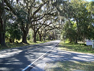
Floral City is a census-designated place (CDP) in Citrus County, Florida, United States. The population was 5,216 at the 2010 census. The community is home to the Floral City Heritage Hall Museum and hosts the Floral City Heritage Days the first weekend in December. The area has a history of phosphate mining and includes historic homes.

Hernando is a census-designated place in Citrus County, Florida, United States. The population was 9,054 at the 2010 census. At one time it was a city but it was disincorporated in the 1970s.
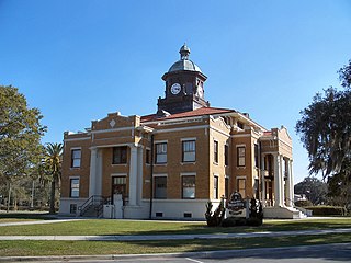
Inverness is a city in Citrus County, Florida, United States. As of the 2010 census, the population was 7,210. It is the county seat of Citrus County and is home to the Citrus County Courthouse and near the 10,950-acre (4,430 ha) Flying Eagle Preserve.

Fort Cooper State Park is a 710-acre historic site in Inverness, Florida, United States. It is located two miles (3 km) south of Inverness, off of U.S. Hwy. 41 on South Old Floral City Road. On June 13, 1972, it was added to the United States National Register of Historic Places. It is also a Florida State Park.

Withlacoochee State Trail is a 46-mile (74 km) long paved, multi-use, non-motorized rail trail in Florida located in Citrus, Hernando and Pasco counties. It follows along the Withlacoochee River and passes through the Withlacoochee State Forest. It is the longest paved rail trail in Florida.

The Withlacoochee River originates in central Florida's Green Swamp, east of Polk City. It flows west, then north, and then turns northwest and finally west again before it empties into the Gulf of Mexico near Yankeetown. The river is 141 miles (227 km) long and has a drainage basin of 1,170 square miles (3,000 km2). It is believed to have been named after the Withlacoochee River to the north.
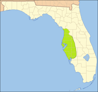
The Southwest Florida Water Management District, is one of five regional agencies directed by Florida state law to protect and preserve water resources. Established in 1961 the agency operates and maintains several large properties and flood protection projects, sometimes with other agencies. The District's responsibilities have expanded to include managing water supply and protecting water quality and the natural systems — rivers, lakes, wetlands and associated uplands.
U.S. Route 41 (US 41) in the U.S. state of Florida is a north–south United States Highway. It runs 479 miles (771 km) from Miami in South Florida northwest to the Georgia border north of the Lake City area. Within the state, US 41 is paralleled by Interstate 75 (I-75) all the way from Miami to Georgia, and I-75 has largely supplanted US 41 as a major highway.
Acuera was the name of both an indigenous town and a province or region in central Florida during the 16th and 17th centuries. The indigenous people of Acuera spoke a dialect of the Timucua language. In 1539 the town first encountered Europeans when it was raided by soldiers of Hernando de Soto's expedition. French colonists also knew this town during their brief tenure (1564–1565) in northern Florida.
The indigenous peoples of Florida lived in what is now known as Florida for more than 12,000 years before the time of first contact with Europeans. However, the indigenous Floridians have largely died out with some completely by the early 18th century. Some Apalachees migrated to Louisiana, where their descendants now live; some were taken to Cuba and Mexico by the Spanish in the 18th century, and a few may have been absorbed into the Seminole and Miccosukee tribes.

Uzita (Uçita) was the name of a 16th-century native chiefdom, its chief town and its chiefs. Part of the Safety Harbor culture, it was located in present-day Florida on the south side of Tampa Bay.
The Safety Harbor culture was an archaeological culture practiced by Native Americans living on the central Gulf coast of the Florida peninsula, from about 900 CE until after 1700. The Safety Harbor culture is defined by the presence of Safety Harbor ceramics in burial mounds. The culture is named after the Safety Harbor Site, which is close to the center of the culture area. The Safety Harbor Site is the probable location of the chief town of the Tocobaga, the best known of the groups practicing the Safety Harbor culture.

Flying Eagle Preserve is located in Inverness, Florida in Citrus County, Florida and managed as part of the Southwest Florida Water Management District. The 10,950-acre (44.3 km2) park is located at 11080 East Moccasin Slough Road in Inverness, Florida and bounded on the east by the Withlacoochee River and is surrounded, in large part, by the Tsala Apopka Chain of Lakes. The preserve provides the setting for various aquatic and sporting activities.
Potts Preserve is an 8,500-acre (34 km2) property protected by the Southwest Florida Water Management District in Inverness, Florida. Wetlands in the preserve "play a role in both the Tsala Apopka Chain of Lakes and the Withlacoochee River systems." Biking, birdwatching, camping, horseback riding, boating, fishing, hiking and hunting, are offered in the park.

Orange Lake is in Alachua County, Florida, about 10 miles (16 km) south of Hawthorne. It has an area of about 12,550 acres (5,080 ha), and is part of the Orange Creek Basin, which is in turn part of the Oklawaha River watershed. Cross Creek flows into it from Lochloosa Lake, and Orange Creek drains it into the Rodman Reservoir. Orange Lake also receives water from Newnans Lake that has been diverted from its historic destination of Paynes Prairie. Orange Lake is noted for fishing, especially bass, with many fishing camps on its shores. The lake also has many natural floating islands, which have an "unusually high diversity", especially of amphibians.
Ocale was the name of a town in Florida visited by the Hernando de Soto expedition, and of a putative chiefdom of the Timucua people. The town was probably close to the Withlacoochee River at the time of de Soto's visit, and may have later been moved to the Oklawaha River.
San Buenaventura de Potano was a Spanish mission near Orange Lake in southern Alachua County or northern Marion County, Florida, located on the site where the town of Potano had been located when it was visited by Hernando de Soto in 1539. The Richardson/UF Village Site (8AL100), in southern Alachua County, has been proposed as the location of the town and mission.


