Franklin County is a county along the Gulf of Mexico in the Florida panhandle of the U.S. state of Florida. As of the 2010 census, the population was 11,549, making it the third-least populous county in Florida. The county seat is Apalachicola.
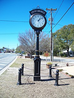
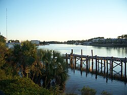
Carrabelle is a city in Franklin County along Florida's Panhandle, United States. The population was 2,778 as of the 2010 census. Carrabelle is located east of Apalachicola at the mouth of the Carrabelle River on the Gulf of Mexico.

The Gulf Intracoastal Waterway is the portion of the Intracoastal Waterway located along the Gulf Coast of the United States. It is a navigable inland waterway running approximately 1,050 mi (1,690 km) from Carrabelle, Florida, to Brownsville, Texas.

The Carrabelle, Tallahassee and Georgia Railroad was a short railroad running in north Florida and southern Georgia.

SR 10 was defined by number in 1923 state law, chapter 9311, approved June 8, 1923:

Tate's Hell State Forest aka Tate's Hell Swamp is 202,000 acres (819 km²) of land in Franklin and Liberty counties in Florida. The forest is located near Carrabelle off US 98 along the Gulf coast and on St. James Island. At one time, Tate's Hell supported at least 12 major habitats including: wet flatwoods, wet prairie, seepage slope, baygall, floodplain forest, floodplain swamp, basin swamp, upland hardwood forest, sandhill, pine ridges, dense titi swamp thickets and scrub. Tate's Hell State Forest is an important hydrologic area and includes a section of the New River. The park's watershed provides fresh water into the Apalachicola Bay, the Carrabelle River and the Ochlockonee River.

The Crooked River Light, also known as the Carrabelle Light, was built in 1895 to replace the Dog Island Light on Dog Island, which had been destroyed in 1875 by a hurricane. The location on the mainland allowed the light to serve as the rear range light for the channel to the west of Dog Island, used by ships in the lumber trade.

The Dog Island Light was located on the western tip of Dog Island south of Carrabelle, Florida. It marked the "middle entrance to St. George's Sound," between St. George and Dog Islands, during the nineteenth century, until its collapse by a hurricane in 1873.
Florida's Forgotten Coast is a registered trademark, coined in the early 1990s, by the Apalachicola Bay Chamber of Commerce. The name is most commonly used to refer to a relatively quiet, undeveloped and largely uninhabited section of coastline stretching from Mexico Beach on the Gulf of Mexico to St. Marks on Apalachee Bay in the U.S. state of Florida. The nearest major cities are Tallahassee, about 90 miles (145 km) northeast of Apalachicola, and Panama City, home of Tyndall Air Force Base, about 60 miles (95 km) to the northwest.

SS Tarpon was a ship which sank in 1937 near Panama City, Florida, United States. The shipwreck is located 7.8 nautical miles (14.4 km) off the shore of Panama City. It became the sixth Florida Underwater Archaeological Preserve when it was dedicated in 1997. In May 2001, it was added to the U.S. National Register of Historic Places.
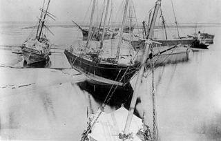
James A. Garfield was an American three-masted bark which was wrecked on the Gulf coast of Florida.
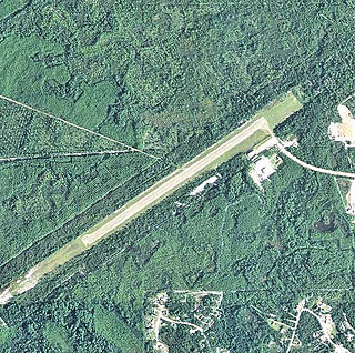
Carrabelle–Thompson Airport is a public use airport located three nautical miles (6 km) west of the central business district of Carrabelle, a city in Franklin County, Florida, United States. It is owned by the Carrabelle Port and Airport Authority.

The McKissack Ponds are five small ponds in the city limits of Carrabelle, Franklin County, Florida, just west – 0.3 miles (0.48 km) to 0.8 miles (1.3 km) – of the Carrabelle–Thompson Airport, on the north and south sides of Airport Road. The McKissack Ponds are owned by Franklin County.

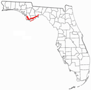
Crooked River is a waterway in Franklin County, Florida, that connects the tidal estuary of the Ochlockonee River to a junction with the tidal Carrabelle River and the New River above the town of Carrabelle, Florida. The Crooked River channel is 41 kilometres (25 mi) long, while its ends are 24 kilometres (15 mi) apart.
New River is in the Florida Panhandle. It originates in the far north of the Apalachicola National Forest and joins with the Crooked River (Florida) above Carrabelle, Florida to become the Carrabelle River, which opens onto St. George Sound and the Gulf of Mexico. The New River watershed drains a large part of Liberty County, Florida with the Apalachicola River to the west and the Wakulla River to the east.
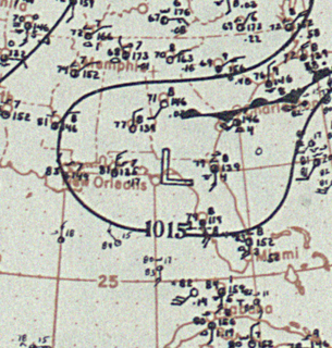
The 1899 Carrabelle hurricane caused significant damage in the Dominican Republic and the Florida Panhandle. The second tropical cyclone and second hurricane of the 1899 Atlantic hurricane season, the storm was first observed south of the Dominican Republic on July 28, 1899. Shortly thereafter, it made landfall in Azua Province, Dominican Republic with an intensity equivalent to a Category 1 hurricane on the modern-day Saffir–Simpson hurricane wind scale. Early on July 29, the system weakened to a tropical storm, shortly before emerging into the Atlantic Ocean. It then moved west-northwestward and remained at the same intensity for the next 24 hours. The storm made landfall near Islamorada, Florida on July 30. It then brushed Southwest Florida before emerging into the Gulf of Mexico. The storm began to re-intensify on July 31 and became a hurricane later that day. Early on August 1, it peaked with winds of 100 mph (155 km/h), several hours before making landfall near Apalachicola, Florida at the same intensity. The storm quickly weakened inland and dissipated over Alabama on August 2.

The Georgia, Florida and Alabama Railroad, known as the Sumatra Leaf Route, and colloquially as the Gopher, Frog & Alligator was a 180 miles (290 km)-long railroad from Richland, Georgia to Carrabelle, Florida. It was founded in 1895 as a logging railroad, the Georgia Pine Railway.