Pottsburg Creek

Last updated
Pottsburg Creek
Pottsburgcreekboatramp1.png
The flooded boat ramp of Pottsburg Creek during Tropical Storm Fay.
Location
Country United States
Physical characteristics
Source 
 - locationPond near J. Turner Butler Blvd.
Mouth  
 - location
St. Johns River
near Arlington.
Length16 miles (26 km)

The Pottsburg Creek is an urban creek in Jacksonville, Florida. Its beginning is near a retention pond behind the old studios of WJXX. It outputs into the Arlington River (north of Atlantic Boulevard and west of Arlington Road) which in turn empties into the St. Johns River. The creek primarily flows through the heart of Jacksonville's Southside, and through southern parts of the Arlington neighborhood.

Jacksonville, Florida Largest city in Florida

Jacksonville is the most populous city in Florida, the most populous city in the southeastern United States and the largest city by area in the contiguous United States. It is the seat of Duval County, with which the city government consolidated in 1968. Consolidation gave Jacksonville its great size and placed most of its metropolitan population within the city limits. As of 2017 Jacksonville's population was estimated to be 892,062. The Jacksonville metropolitan area has a population of 1,523,615 and is the fourth largest in Florida.

WJXX ABC affiliate in Orange Park, Florida

WJXX, virtual channel 25, is an ABC-affiliated television station serving Jacksonville, Florida, United States that is licensed to Orange Park. The station is owned by Tegna Inc., as part of a duopoly with Jacksonville-licensed NBC affiliate WTLV. The two stations share studio facilities on East Adams Street in downtown Jacksonville; WJXX's transmitter is located on Eve Drive in the city's Kilarney Shores section.

St. Johns River The longest river in Florida, United States

The St. Johns River is the longest river in the U.S. state of Florida and its most significant one for commercial and recreational use. At 310 miles (500 km) long, it flows north and winds through or borders twelve counties. The drop in elevation from headwaters to mouth is less than 30 feet (9 m); like most Florida waterways, the St. Johns has a very low flow rate 0.3 mph (0.13 m/s) and is often described as "lazy". Numerous lakes are formed by the river or flow into it, but as a river its widest point is nearly 3 miles (5 km) across. The narrowest point is in the headwaters, an unnavigable marsh in Indian River County. The St. Johns drainage basin of 8,840 square miles (22,900 km2) includes some of Florida's major wetlands. It is separated into three major basins and two associated watersheds for Lake George and the Ocklawaha River, all managed by the St. Johns River Water Management District.

Contents

Tour

The Pottsburg Creek originates in the Southpoint section of Jacksonville's Southside. The origins of the pond are unknown, however, most ideas point to a retention pond near a television studio formerly used by ABC affiliate WJXX. Historical records of Spanish land grants filed with the Florida territorial government, such as for the plot owned by Peter Bagley, [1] indicate a tributary of the Arlington River named Pottsburg Creek on maps of the area as early as 1824. The creek starts out as very narrow, and almost swamplike canal. The creek travels under busy J. Turner Butler Blvd., heading north. The creek here is very overgrown, and almost impossible to see while driving at the normal speed limit. The creek meanders north through suburban parts of Jacksonville, being fed directly or indirectly by heavy amounts of pollution and fertilizers.[ citation needed ] Many retention ponds and storm drains owned by JEA, the utility company, feed into this part of the creek. This creates a heavily fluctuating water level through this section. The creek continues north where it approaches U.S. 90/SR 212/Beach Blvd. Located along the creeks are several television transmitters, including ones for WFOX-TV, WJAX-TV, and WCWJ. The transmitters for WTLV, WJXT, and the digital transmitter for WJXX are also visible nearby, across busy Southside Blvd. This area is known as Killarney Shores. The creek begins to widen as it starts to head out of the southside area and into Arlington. The creek is also frequented by boat traffic due to the city boat ramp nearby. [2] Soon the creek is joined by the spring run for Pottsburg Spring and the Little Pottsburg Creek. The creek widens even more as it passes under Atlantic Blvd. and out to the St. Johns River.

American Broadcasting Company American broadcast television network

The American Broadcasting Company (ABC) is an American commercial broadcast television network that is a flagship property of Walt Disney Television, a subsidiary of the Disney Media Networks division of The Walt Disney Company. The network is headquartered in Burbank, California on Riverside Drive, directly across the street from Walt Disney Studios and adjacent to the Roy E. Disney Animation Building, But the network's second corporate headquarters and News headquarters remains in New York City, New York at their broadcast center on 77 West 66th Street in Lincoln Square in Upper West Side Manhattan.

State Road 202 (SR 202) is a 13.042-mile-long (20.989 km) state highway that extends from U.S. Route 1, in Jacksonville, Florida to SR A1A, in Jacksonville Beach, near the Atlantic Ocean, just north of Ponte Vedra Beach, and includes a bridge over the Intracoastal Waterway. To locals, the road is better known as J. Turner Butler Boulevard, Butler Boulevard, or JTB. Except for a 0.5-mile-long (800 m) section from US 1 to Interstate 95 (I-95), it is a completely limited-access expressway. It was constructed in sections by the Jacksonville Transportation Authority. The first section opened in 1979, but was not completed until 1997.

Tributaries

The Pottsburg Creek is mainly fed by rainwater, retention ponds, and storm drain runoff. Other named tributaries include the Little Pottsburg Creek, Strawberry Creek, Silversmith Creek, and discharge from the Pottsburg Spring. [3]

See also

Related Research Articles

The Henry Holland Buckman Bridge carries I-295 West Beltway traffic over the St. Johns River in Jacksonville, Florida. It was named for Henry Holland Buckman, a prominent legislator and attorney who was instrumental in establishing the Florida state road system.

Ichetucknee River River in Florida, United States

The Ichetucknee River is a spring-fed, pristine river in North Central Florida. The entire 6 miles (9.7 km) of the river average 20 feet (6.1 m) wide, 5 feet (1.5 m) deep and most of the 6 miles lie within the boundaries of the Ichetucknee Springs State Park while the rest is to the south of US Highway 27. Three Rivers Estates Property Owners (TREPO) is the property owner association that manages the area along the private side of the river as it travels and flows into the Santa Fe River.

Halifax River River in Florida, United States

The Halifax River is part of the Atlantic Intracoastal Waterway, located in northeast Volusia County, Florida. The waterway was originally known as the North Mosquito River, but was renamed after George Montagu-Dunk, 2nd Earl of Halifax, during the British occupation of Florida (1763–1784).

Interstate 95 (I-95) is the main Interstate Highway of Florida's Atlantic Coast. It begins at a partial interchange with U.S. Highway 1 (US 1) just south of downtown Miami, and heads north past Daytona Beach, through Jacksonville, and to the Georgia state line at the St. Marys River near Becker. The route also passes through the cities of Fort Lauderdale, West Palm Beach, and Titusville.

Florida State Road 115 highway in Florida

State Road 115 is a state highway in the U.S. state of Florida.
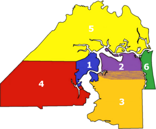
Neighborhoods of Jacksonville

There are more than 500 neighborhoods within the area of Jacksonville, Florida, the largest city in the contiguous United States by area. These include Downtown Jacksonville and surrounding neighborhoods. Additionally, greater Jacksonville is traditionally divided into several major sections with amorphous boundaries: Northside, Westside, Southside, and Arlington, as well as the Jacksonville Beaches.

Beach Boulevard is an east–west road running from Jacksonville, Florida, United States east to Jacksonville Beach. Most of the road is part of U.S. Route 90 and unsigned as State Road 212, and a small portion at the eastern end is unsigned as County Road 212.

State Road 109 is a state road in Jacksonville, Florida. It is a north–south road that starts at SR 13 and ends at Jacksonville University. SR 109 is known as University Boulevard because the route forms the eastern border of Jacksonville University's campus.

Little River (Etowah River tributary)

The Little River is a 29.3-mile-long (47.2 km) tributary of the Etowah River in the U.S. state of Georgia in the United States.

The Trout River is a 20-mile-long (32 km) tributary of the St. Johns River in Duval County, Florida. Located entirely within Jacksonville, the river is brackish in its lower section. The widest point of the river is near the St. Johns River, where it is 0.6 miles (1.0 km) across. The Trout River has wetlands as far as the mouth of the river's longest tributary, the Ribault River.

U.S. Route 17 in Florida highway in Florida

U.S. Route 17 (US 17) in Florida is a north–south United States Highway. It runs 317 miles (510 km) from the Punta Gorda, Florida Metropolitan Statistical Area northeast to the Greater Jacksonville Metropolitan Area.

Silver River (Florida) River in the United States of America

The Silver River is a short spring-fed river located east of Ocala in Marion County, Florida. Fed by Silver Springs, it connects the springs to the Ocklawaha River, passing through a pristine woodland environment. The river was probably named for its silvery appearance.

Chassahowitzka River River in the United States of America

The Chassahowitzka River is a spring-fed river located in southwestern Citrus County, Florida. The 5-mile-long (8 km) river is home to hundreds of species of birds including the bald eagle, and is a common refuge for the West Indian manatee. In 1941, approximately 31,000 acres (13,000 ha) of its saltwater creeks, freshwater tributaries, and hardwood hammocks were recognized as Chassahowitzka National Wildlife Refuge. It is accessible by boat from a nearby public boat ramp that is located at the campground that also bears its Indian name which means "land of hanging pumpkins;" a reference to a wild variety that once grew along the banks.

Black Creek (Florida) River in Florida, United States of America

Black Creek is a 13.0-mile-long (20.9 km) tributary of the St. Johns River. It is located in Clay County, Florida. Black Creek has two major tributaries; North Fork Black Creek and South Fork Black Creek. North Fork originates as an outflow from Kingsley Lake and flows north and then east through Camp Blanding and Jennings State Forest, meeting South Fork in Middleburg, Florida. North Fork Black Creek has Yellow Water Creek and Big Branch as its main tributaries. South Fork Black Creek is fed by areas of wetlands and numerous small streams. The confluence of North Fork Black Creek and South Fork Black Creek near Middleburg form the main channel of Black Creek.
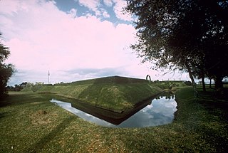
Arlington (Jacksonville) Neighborhood of Jacksonville in Florida

Arlington is a large neighborhood of Jacksonville, Florida, generally understood as one of the city's large "sides", the others being Northside, Southside and Westside. It borders the Southside area at its southern end, and has several bridge connections to nearby beaches, the Northside and Downtown. The expansive neighborhood was incorporated into the city in 1968 as a result the Jacksonville Consolidation, a city-county consolidation of the governments of the City of Jacksonville and Duval County. Arlington is known for its mid-century modern architecture, and contains several architectural significant homes designed by local architects Robert C. Broward, Taylor Hardwick, and William Morgan.

Sheldrake River river in the United States of America

The Sheldrake River is a freshwater stream located in Southern Westchester County, New York. The river forms in White Plains and flows six miles (9.7 km) south until it joins the Mamaroneck River. Approximately 1.58 miles (2.54 km) of the Sheldrake River flow through Scarsdale, 2.13 miles (3.43 km) through New Rochelle and two miles (3.2 km) through the Town of Mamaroneck.

Wendigo Creek was a short watercourse in Toronto, Ontario, that drains into Grenadier Pond. It was spring fed, like nearby Spring Creek. Its headwaters were north of Bloor Street, near Dundas Street and Laws Street.

References

  1. "Bagley, Peter: Spanish Land Grants". State Library and Archives of Florida. Retrieved 2010-07-27.
  2. "COJ Pottsburg Creek Boat Ramp". City of Jacksonville . Retrieved 2008-11-17.
  3. "Pottsburg Creek Spring". St. Johns River Water Management District . Retrieved 2008-11-17.