Ray City, Georgia | |
|---|---|
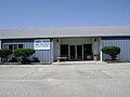
 Ray City Municipal Building | |
 Seal | |
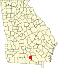
 Location in Berrien County and the state of Georgia | |
| Coordinates: 31°4′32″N83°11′51″W / 31.07556°N 83.19750°W | |
| Country | United States |
| State | Georgia |
| Counties | Berrien, Lanier |
| Government | |
| • Mayor | Brenda Exum |
| Area | |
• Total | 1.15 sq mi (2.97 km2) |
| • Land | 1.15 sq mi (2.97 km2) |
| • Water | 0.00 sq mi (0.00 km2) |
| Elevation | 190 ft (58 m) |
| Population (2020) | |
• Total | 956 |
| • Density | 834.21/sq mi (322.03/km2) |
| Time zone | UTC-5 (Eastern (EST)) |
| • Summer (DST) | UTC-4 (EDT) |
| ZIP code | 31645 |
| Area code | 229 |
| FIPS code | 13-63728 [2] |
| GNIS feature ID | 0332800 [3] |
Ray City is a city in Berrien County and Lanier County, Georgia, United States. The population was 956 in 2020. [4] [5]