Stockton, Georgia | |
|---|---|
 Stockton Post Office | |
 Stockton  Stockton | |
| Coordinates: 30°56′26″N83°0′32″W / 30.94056°N 83.00889°W | |
| Country | United States |
| State | Georgia |
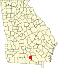
| County | Lanier |
| Population (2020) | |
• Total | 135 |
| Time zone | UTC-5 (Eastern (EST)) |
| • Summer (DST) | UTC-4 (EDT) |
| ZIP codes | 31649 |
Stockton is an unincorporated community and census-designated place (CDP) in Lanier County, Georgia, United States. [1]
Contents
Stockton is located in the far southern portion of the state on U.S. Highway 84, near Valdosta and Lakeland. The surrounding area produces tobacco, turpentine, pine lumber, and pulpwood. Moody Air Force Base is located nearby, and transport is provided mainly by U.S. Route 84 and U.S. Route 129. Stockton is located near the Alapaha River and CSX Transportation runs through Stockton at least twice a day. Stockton's zip code is 31649.
The 2020 census listed a population of 135. [2]