Bannockburn, Georgia | |
|---|---|
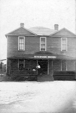 Riverside Hotel in Bannockburn, circa 1905 | |
 Bannockburn, Georgia | |
| Coordinates: 31°17′06″N83°03′27″W / 31.28500°N 83.05750°W | |
| Country | United States |
| State | Georgia |
| County | Berrien |
| Elevation | 226 ft (69 m) |
| Time zone | UTC-5 (Eastern (EST)) |
| • Summer (DST) | UTC-4 (EDT) |
| GNIS feature ID | 326166 [1] |
Bannockburn is an unincorporated community in Berrien County, Georgia, United States. [1]
The former Central of Georgia Railway ran through the settlement.
The Riverside Hotel in Bannockburn was built around 1905. At the same time, the Massey Felton Lumber Company operated a sawmill on the west side of the Alapaha River, about 1 mi (1.6 km) east of Bannockburn. The mill closed about 1910. [2]
