Lowndes County, Georgia

Last updated • 14 min readFrom Wikipedia, The Free Encyclopedia

Lowndes County
Courthouse of Lowndes County, Georgia.jpg
Lowndes County Courthouse in Valdosta
LowndesCountyGAseal.png
LowndesCountyGAlogo.png
Map of Georgia highlighting Lowndes County.svg
Location within the U.S. state of Georgia
Georgia in United States.svg
Georgia's location within the U.S.
Coordinates: 30°50′N83°16′W / 30.83°N 83.27°W / 30.83; -83.27
CountryFlag of the United States.svg United States
StateFlag of Georgia (U.S. state).svg  Georgia
FoundedDecember 23, 1825;199 years ago (1825)
Named for William Jones Lowndes
Seat Valdosta
Largest cityValdosta
Area
  Total
511 sq mi (1,320 km2)
  Land496 sq mi (1,280 km2)
  Water15 sq mi (40 km2)  2.8%
Population
  Estimate 
(2022)
120,055
  Density220/sq mi (80/km2)
Time zone UTC−5 (Eastern)
  Summer (DST) UTC−4 (EDT)
Congressional districts 1st, 8th
Website lowndescounty.com

Lowndes County ( /ˈlndz/ ) is a county located in the south-central portion of the U.S. state of Georgia. As of the 2020 census, the population was 118,251. [1] The county seat is Valdosta. [2] The county was created December 23, 1825.

Contents

Lowndes County is included in the Valdosta metropolitan statistical area. It is located along the border with Florida.

The county is a major commercial, educational, and manufacturing center of south Georgia with considerable forest products including pulpwood and naval stores, such as turpentine and rosin. Part of Grand Bay, a 13,000-acre (53 km2) wetlands, is located in Lowndes County.

History

Native Americans and the Spanish

The land that became Lowndes County had historically been inhabited by the Timucua. During most of the age of European colonization, the area of modern Lowndes County was part of the colony of Spanish Florida. From approximately 1625 to 1657, the Spanish Empire maintained a Catholic mission to the Timucua, dubbed Mission Santa Cruz de Cachipile, in the southern portion of Lowndes County near present-day Lake Park. In the centuries that followed, Timucua civilization collapsed due to slave raiding and disease.

The Creek Nation peoples moved into the area and, by the early 19th century, they were well established here. On December 15, 1818, European Americans organized what they called Irwin County, which had been settled by pushing out the Creek people. In the 1830s Georgia and the federal government completed Indian Removal of most of the Native Americans from what became the state.

Early county history

Lowndes County was established by an act passed by the Georgia legislature on December 23, 1825. It was formed out of the 8th, 9th, 10th, 11th, 12th, 15th, and 16th land districts of Irwin County, Georgia. [3] The county was named for William Jones Lowndes (1782–1822), a prominent South Carolina lawyer and Congressman. His father Rawlins Lowndes had been a Revolutionary War leader and was elected as South Carolina Governor. [4] The Coffee Road was an improved trail first cut by Georgia militia to supply federal troops in Florida during the Creek Wars. It was the first route through the area of Lowndes County and opened up the area to white settlers.

During the first few years after Lowndes County was organized, its courts met at the tavern owned by Sion Hall on the Coffee Road, near what is now Morven, Georgia in Brooks County, on the west side of the Little River. The first county seat was established at Franklinville (sometimes spelled Franklynville) by the Georgia General Assembly on December 16, 1828. [5] Franklinville was located about 5.6 miles to the east of Hahira in the eastern half of land lot 50 in the 11th land district; it was named after statesman and Founding Father of the United States, Benjamin Franklin.

At the time of the 1830 federal census, Lowndes County had 1,072 white males, 1,044 white females, 156 male slaves, 179 female slaves, and 4 free people of color, for a total population of 2,455. The introduction of steam-powered ships on the Withlacoochee and Little rivers led to a shift in the population toward the rivers. In December 1833 the state legislature passed a law establishing a new county seat at a place to be called Lowndesville. The law called for a courthouse, a jail, and a town to be laid out within land lot 109 in the 12th land district. This land lot is near the present Timber Ridge Road in Lowndes County.

It is uncertain why the plans for Lowndesville were abandoned, but in December 1834, the state legislature authorized commissioners to select a suitable site for a courthouse so that the county seat could be moved away from Franklinville. In October 1836, another group of commissioners was advertising for contracting proposals for the construction of a brick courthouse at Troupville. By Summer 1837, Troupville and Franklinville were both serving as courthouse sites. This continued until at least 1838. In December 1837 Troupville was incorporated. Rumors of the coming of the Brunswick and Chattahoochee Railroad, the opening up of Florida, and the prosperity of the surrounding farmland led to the growth of Troupville and Lowndes County in general. In 1845, the remaining county-owned land at Franklinville was sold at the courthouse in Troupville.

The closest battle to Troupville between Native Americans and whites was at Brushy Creek on November 10, 1836, in modern Berrien County. Creek Nation people were passing through Lowndes County to join the Seminole in Florida. General Winfield Scott, commander of United States field forces in the area, intended to stop the Creek movement and did. Virtually no Native Americans were left in South Georgia.

In February 1850 Lowndes County lost land to the formation of Clinch County. At that time the eastern border of Lowndes County was defined as the Alapaha River. [6] By the time of the 1850 census, Lowndes County had a free white population of 5,339, a free colored population of 20, and a slave population of 2,355. Lowndes County lost additional territory with the establishment of Berrien and Colquitt counties on February 25, 1856.

Establishment of Valdosta

Many residents of Lowndes County were unhappy when the Atlantic and Gulf Railroad announced June 17, 1858, that they had selected a planned route that would bypass Troupville. On June 22 at 3:00 AM, the Lowndes County courthouse at Troupville was set aflame by William B. Crawford, who fled to South Carolina after being released on bond.

On August 9, a meeting convened in the academy building in Troupville at which it was decided to create from the area of Lowndes County to the west of the Withlacoochee River a new county to be called Brooks County. [7] Brooks was established on December 11. On December 13, 1858, the Georgia General Assembly passed a bill establishing Echols County, Georgia.

In December 1859, the Lowndes County board of commissioners were instructed by an act of the Georgia legislature to purchase land for a new county seat; it was to be along the line of the Atlantic and Gulf Railroad and as close to the center of the county as possible. As part of the same act the Brooks-Lowndes County border was adjusted so that the east bank of the Little River formed the border. [8]

Land belonging to William Wisenbaker was chosen as the site of the new county seat of Valdosta. The arrival of the railroad led to the downfall of Troupville and the rise of Valdosta as a center for the economy of south Georgia. The shifting county boundary lines led to population loss for Lowndes County. The 1860 census showed the county having 2,850 free whites, no free persons of color, and 2,399 slaves.

Civil War

No battles during the American Civil War were fought in Lowndes County. Several regular Confederate Army companies were raised from the population. Those included:

State Guard units included:

In addition, two Georgia Militia companies were partially raised from the population in early 1864 following the reorganization of the militia. [9] Those included:

Lowndes County also had a home guard unit, but it was only called into action once in the fall of 1863. In that instant some soldiers' wives in Thomasville, Georgia were threatening to break into a Confederate Government Commissary to feed their starving children. In April 1864 a group of women rioted at Stockton, Georgia after a local store owner refused to take Confederate money in exchange for yarn. They took all the yarn in his store. At the same time, armed women stole a wagon load of bacon from a government warehouse. A mob of women also went on a rampage for similar reasons in Naylor, Georgia at about the same time. [10]

In February 1864 members of Company I "Woodson Guards", 32nd Regiment Georgia Infantry camped overnight in Valdosta at an area south of the railroad while on their way to Battle of Olustee in northern Florida. It was to be the closest fighting came to Valdosta during the Civil War. Valdosta became a home for many refugees fleeing into south Georgia due to Sherman's March to the Sea. Among those refugees was the family of Doc Holliday. Other refugees came by the railroad from Savannah and the Sea Islands. [11]

Reconstruction

In the years right after the Civil War, members of Company "G", 103rd United States Colored Troops were stationed at Valdosta as part of the military occupation of the South during the Reconstruction era.

Several years after the Civil War, 112 African American men, women, and children moved from Lowndes County to Arthington, Liberia in 1871 and 1872. Some settled there permanently to make their home in a colony established for free American blacks; a small number returned to the United States. Their emigration was supported by the American Colonization Society, which had been working since the antebellum years to relocate free blacks to this new colony in West Africa. [12] African Americans dominated the new colony (and future country) both socially and politically well into the 20th century before indigenous peoples, the majority within the borders of the country, came to power.

Prior to 1872, the southern border of Lowndes County and of Georgia was slightly farther south. The border when Lowndes County was created was along what was called McNeil's Line. A dispute over the border between the states of Florida and Georgia later developed (see Florida v. Georgia ). In 1857, the governors of the two states appointed surveyors for a joint survey of the border. This led to the creation of the Orr and Whitney Line, which was agreed to by the United States Congress on April 9, 1872.

20th century to present

In 1899 the cotton mill town of Remerton was established, and by 1920, Lowndes County lost some territory when Lanier County was established.

Lynching of Mary Turner and killing of her unborn child

In 1918, a white planter was murdered in Brooks County. He was known to have mistreated his black workers. Sidney Johnson, one of his workers, was suspected in his death. Mobs of whites hunted in Brooks and Lowndes counties for Johnson, rounding up and killing at least 11 other black men and one black woman and her unborn baby in what historian Meyers called "a lynching rampage." One man was killed in Lowndes County and the others in Brooks. Mary Turner, the married mother of two young children and eight months pregnant, was brutally murdered in Lowndes County, near Folsom Bridge on the Little River. The unborn child was then cut from her womb and its head crushed by a booted foot of one of the participants in the lynching. Her husband had been lynched the day before although neither had anything to do with the white planter's death. [13] None of the lynching participants were prosecuted.

On May 15, 2010, a historical marker memorializing "Mary Turner and the Lynching Rampage" was placed near the lynching site in Lowndes County and dedicated. [14] The plaque includes a description of the associated murders of black people by white mobs in 1918, especially the lynchings of the Turners. [15] [16] [ failed verification ] In July 2013, the plaque was found to have five bullet holes shot by an unknown vandal. [17] Since 2013, the plaque now has as many as 27 bullet holes and more recently, was struck multiple times by “some kind of off-road vehicle,” Mark Patrick George, coordinator for the Mary Turner Project, announced in October 2020. The historical marker has been since removed. Project officials said the historical marker will be stored until re-installment plans are made. It is unclear if authorities are investigating the latest vandalism incident. [18]

World War II

On September 15, 1941, Moody Air Force Base opened. it was part of the federal government's investment in military facilities in the South. The region received considerable Federal monies during World War II.

Geography

According to the U.S. Census Bureau, the county has a total area of 511 square miles (1,320 km2), of which 496 square miles (1,280 km2) is land and 15 square miles (39 km2) (2.8%) is water. [19]

The north-central (east of Hahira), west-central (bordered by a north–south line that bisects Valdosta), and southwestern portions (west of Dasher) of Lowndes County are located in the Withlacoochee River sub-basin of the Suwannee River basin. The northwestern corner of the county is located in the Little River sub-basin of the same Suwannee River basin. The eastern portion of Lowndes County is located in the Alapaha River sub-basin of the larger Suwannee River basin. [20]

Adjacent counties

Major waterways

Communities

Cities

Town

Census-designated place

Unincorporated communities

Demographics

Historical population
CensusPop.Note
1830 2,453
1840 5,574127.2%
1850 7,71438.4%
1860 5,249−32.0%
1870 8,32158.5%
1880 11,04932.8%
1890 15,10236.7%
1900 20,03632.7%
1910 24,43622.0%
1920 26,5218.5%
1930 29,99413.1%
1940 31,8606.2%
1950 35,21110.5%
1960 49,27039.9%
1970 55,11211.9%
1980 67,97223.3%
1990 75,98111.8%
2000 92,11521.2%
2010 109,23318.6%
2020 118,2518.3%
2023 (est.)120,712 [21] 2.1%
U.S. Decennial Census [22]
1790-1880 [23] 1890-1910 [24]
1920-1930 [25] 1930-1940 [26]
1940-1950 [27] 1960-1980 [28]
1980-2000 [29] 2010 [30]
Lowndes County racial composition as of the 2020 census [31]
RaceNum.Perc.
White 59,30650.15%
Black or African American 43,94637.16%
Native American 3120.26%
Asian 1,9081.61%
Pacific Islander 1000.08%
Other/Mixed 4,8074.07%
Hispanic or Latino 7,8726.66%

As of the 2020 United States census, there were 118,251 people, 42,639 households, and 26,536 families residing in the county. [31]

Courthouses

The Old Lowndes County Courthouse as it appeared around the early 1900s. Lowndes County Courthouse 1900.JPG
The Old Lowndes County Courthouse as it appeared around the early 1900s.

The county's former courthouse was built circa 1905 and is listed on the National Register of Historic Places; it was the county's seventh courthouse. The first courthouse was built in 1828 at Franklinville, the original county seat. In 1834 another courthouse was built at the new county seat of Troupville. It was replaced by a new courthouse in 1842. The 1842 structure was destroyed by a fire set by William B. Crawford in June 1858.

The first courthouse at Valdosta was built in 1860 and was a wooden structure that was sold for the funding of a new courthouse by 1869. The wooden building used for the courts of ordinary burned down in 1869. Lowndes County was without an official courthouse for a number of years. A two-story brick building was completed in 1874. In 1900, county commissioners decided that a larger structure was needed. In March 1904 the old courthouse was demolished and in 1905, the seventh courthouse was completed. This is the structure that is locally referred to in the 21st century as 'the old courthouse.' In August and September 2010, the county government moved to a new judicial complex. [32]

The 1905 Lowndes County Courthouse is widely acknowledged as one of the most beautiful county courthouses in Georgia. It is used for meetings, public display, and other community attractions. Today it is used for many events, meetings, and political purposes. [33] [34]

Education

Residents not in the Valdosta city limits are in the Lowndes County School District, while those in the Valdosta city limits are in the Valdosta City School District. [35] Lowndes High School and Valdosta High School are the district's respective comprehensive high schools.

Valwood School is a private school in the county.

Valdosta State University is in Valdosta.

South Georgia Regional Library operates libraries in the county.

Politics

United States presidential election results for Lowndes County, Georgia [36]
Year Republican Democratic Third party(ies)
No.%No.%No.%
2024 28,08158.47%19,48740.57%4620.96%
2020 25,69255.40%20,11643.38%5671.22%
2016 21,63556.84%15,06439.58%1,3643.58%
2012 21,32754.38%17,47044.54%4241.08%
2008 21,26954.19%17,59744.83%3840.98%
2004 18,98159.91%12,51639.50%1870.59%
2000 14,46256.87%10,61641.74%3541.39%
1996 10,57848.92%9,47043.79%1,5767.29%
1992 10,27646.30%9,01940.64%2,89713.05%
1988 10,85562.63%6,42737.08%510.29%
1984 10,43762.86%6,16737.14%00.00%
1980 6,62251.29%5,98946.38%3012.33%
1976 4,51233.82%8,83066.18%00.00%
1972 7,81279.50%2,01520.50%00.00%
1968 3,07327.55%2,40221.53%5,67950.91%
1964 6,81160.95%4,36339.04%10.01%
1960 2,90844.65%3,60555.35%00.00%
1956 2,13535.17%3,93664.83%00.00%
1952 2,07939.05%3,24560.95%00.00%
1948 63416.02%1,86747.17%1,45736.81%
1944 40116.09%2,09283.91%00.00%
1940 2609.21%2,55190.40%110.39%
1936 1303.98%3,09994.89%371.13%
1932 974.99%1,84094.65%70.36%
1928 59629.67%1,41370.33%00.00%
1924 574.71%1,09590.42%594.87%
1920 22014.40%1,30885.60%00.00%
1916 884.36%1,87092.67%602.97%
1912 353.86%84793.49%242.65%
1908 15416.61%68173.46%929.92%
1904 28923.73%88872.91%413.37%
1900 27737.48%44460.08%182.44%
1896 53645.62%58649.87%534.51%
1892 50929.05%98856.39%25514.55%
1888 64345.06%76753.75%171.19%
1884 59847.99%64852.01%00.00%
1880 66046.94%74653.06%00.00%

Up until 1960, Lowndes County voted with the Democrats, as with most of the Solid South. It flipped in 1964 when it voted for Republican Barry Goldwater and has remained reliably Republican since then. The last Democrat to carry the county was Jimmy Carter in 1976.

Transportation

Major highways

Pedestrians and cycling

  • Azalea City Trail
  • VSU Walking Trail System

Railroads

See also

Related Research Articles

<span class="mw-page-title-main">Madison County, Florida</span> County in Florida, United States

Madison County is a county located in the north central portion of the state of Florida, and borders the state of Georgia to the north. As of the 2020 census, the population was 17,968. Its county seat is also called Madison.

<span class="mw-page-title-main">Thomas County, Georgia</span> County in Georgia, United States

Thomas County is a county located in the U.S. state of Georgia. As of the 2020 census the population was 45,798. The county seat is Thomasville. Thomas County comprises the Thomasville, GA micropolitan statistical area.

<span class="mw-page-title-main">Lanier County, Georgia</span> County in Georgia, United States

Lanier County is a county in the south central portion of the U.S. state of Georgia. At the 2020 census, the population was 9,877. The county seat is Lakeland. It is named after Georgia poet Sidney Lanier.

<span class="mw-page-title-main">Irwin County, Georgia</span> County in Georgia, United States

Irwin County is a county located in the U.S. state of Georgia. As of the 2020 census, the population was 9,666. The county seat is Ocilla. The county was created on December 15, 1818. It was named for Governor Jared Irwin.

<span class="mw-page-title-main">Early County, Georgia</span> County in Georgia, United States

Early County is a county located on the southwest border of the U.S. state of Georgia. As of the 2020 census, the population was 10,854. The county seat is Blakely, where the Early County Courthouse is located. Created on December 15, 1818, it was named for Peter Early, 28th Governor of Georgia. The county is bordered on the west by the Chattahoochee River, forming the border with Alabama.

<span class="mw-page-title-main">Echols County, Georgia</span> County in Georgia, United States

Echols County is a county located in the southeastern part of the U.S. state of Georgia. As of the 2020 census, the population was 3,697. The county seat is Statenville. Since 2008, Statenville is a disincorporated municipality. Echols and Webster counties are the only two counties in Georgia to currently have no incorporated municipalities. The county was established in 1858 and named in honor of Robert Milner Echols (1798–1847).

<span class="mw-page-title-main">Cook County, Georgia</span> County in Georgia, United States

Cook County is a county located in the south central portion of the U.S. state of Georgia. As of the 2020 census, the population was 17,229. The county seat is Adel. The constitutional amendment to create the county was proposed July 30, 1918, and ratified November 5, 1918. It is named for former Civil War general Philip Cook of the Confederate States Army.

<span class="mw-page-title-main">Brooks County, Georgia</span> County in Georgia, United States

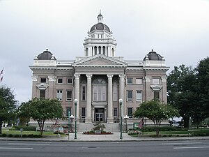
Brooks County is a county located in the U.S. state of Georgia, on its southern border with Florida. As of the 2020 census, the population was 16,301. The county seat is Quitman. The county was created in 1858 from portions of Lowndes and Thomas counties by an act of the Georgia General Assembly and was named for pro-slavery U.S. Representative Preston Brooks, after he severely beat abolitionist Senator Charles Sumner with a cane for delivering a speech attacking slavery.

<span class="mw-page-title-main">Berrien County, Georgia</span> County in Georgia, United States

Berrien County is a county located in the south central portion of the U.S. state of Georgia. As of the 2020 census, the population was 18,160. The county seat is Nashville. The county was created February 25, 1856, out of portions of Coffee, Irwin and Lowndes counties by an act of the Georgia General Assembly. It is named after Georgia senator John M. Berrien.

<span class="mw-page-title-main">Morven, Georgia</span> City in Georgia, United States

Morven is a city in Brooks County, Georgia, United States. It is part of the Valdosta metropolitan statistical area. The city was named after a mountain in Scotland. The population was 565 at the 2010 census, and 506 in 2020. It was formerly known as Sharpe's Store.

<span class="mw-page-title-main">Homerville, Georgia</span> City in Georgia, United States

Homerville is a city and the county seat of Clinch County, Georgia, United States. Its population was 2,456 at the 2010 census, a decrease of 12.38% from 2,803 in 2000. It was incorporated February 15, 1869.

<span class="mw-page-title-main">Lakeland, Georgia</span> City in Georgia, United States

Lakeland is a city and the county seat of Lanier County, Georgia, United States. The city is the county seat of Lanier County. It is part of the Valdosta, Georgia metropolitan statistical area. The population was 2,875 at the 2020 census.

<span class="mw-page-title-main">Lake Park, Georgia</span> City in Georgia, United States

Lake Park is a city in Lowndes County, Georgia, United States. The population was 932 in 2020, up from 733 in 2010.

<span class="mw-page-title-main">Valdosta, Georgia</span> City in Georgia, United States

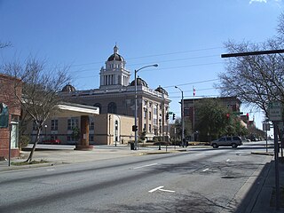
Valdosta is a city in and the county seat of Lowndes County in the U.S. state of Georgia. As the principal city of the Valdosta metropolitan statistical area, which in 2023 had a metropolitan population of 151,118, according to the US Census Bureau its metropolitan area includes Brooks County to the west. With a city population of 55,378 in 2020, Valdosta is the home of Valdosta State University, a regional university in the University System of Georgia with over 12,000 students as of 2021.

"Troupville" is an extinct unincorporated community in Lowndes County, Georgia, United States, near Valdosta. Troupville was a riverboat landing near the confluence of the Withlacoochee River and the Little River at the uppermost navigable point. It was the third county seat of Lowndes County. Troupville was named after Governor George Troup.

<span class="mw-page-title-main">Atlantic and Gulf Railroad (1856–1879)</span>

The Atlantic and Gulf Railroad was chartered in February 1856 by act of the Georgia General Assembly. It was also known as the Main Trunk Railroad. It traversed south Georgia from Screven to Bainbridge, Georgia. Construction began in early January 1859. Its construction was halted by the American Civil War. Construction began again after the end of the war and the line was completed to Bainbridge, Georgia by late December 1867. The route never reached all the way to the Gulf of Mexico as it had originally intended. The company went bankrupt in 1877 and was bought in 1879 by Henry B. Plant and became incorporated into his Plant System. Its main line is currently operated by CSX Transportation. Throughout its history, the Atlantic and Gulf was closely associated with the Savannah and Albany Railroad Company and its successor the Savannah, Albany, and Gulf Railroad.

<span class="mw-page-title-main">Clyattville, Georgia</span> Place in Georgia, United States

Clyattville is an unincorporated community and census-designated place (CDP) in Lowndes County, Georgia, United States. It was established in the 1840s.

<span class="mw-page-title-main">Valdosta metropolitan area</span> Metropolitan statistical area in Georgia, United States

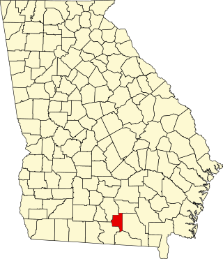
The Valdosta metropolitan area, designated the Valdosta metropolitan statistical area by the U.S. Office of Management and Budget, is a metropolitan statistical area consisting of four counties—Brooks, Echols, Lanier, and Lowndes—centered on the city of Valdosta. Located in Southeast Georgia, the metropolitan area's population was 151,118 according to 2023 U.S. census estimates, up from 149,849 at the 2020 U.S. census.

On May 16, 1918, a plantation owner was murdered, prompting a manhunt which resulted in a series of lynchings in May 1918 in southern Georgia, United States. White people killed at least 13 black people during the next two weeks. Among those killed were Hazel "Hayes" Turner and his wife, Mary Turner. Hayes was killed on May 18, and the next day, his pregnant wife Mary was strung up by her feet, doused with gasoline and oil then set on fire. Mary's unborn child was cut from her abdomen and stomped to death. Her body was then repeatedly shot. No one was ever convicted of her lynching.

<span class="mw-page-title-main">Southeast Georgia</span> 18-county region in Georgia, US

Southeast Georgia is an eighteen-county region within the U.S. state of Georgia, bordering Florida. The region includes a portion of Georgia's Lower Coastal Plain. Southeast Georgia's largest city is Valdosta, which forms the core of the Valdosta metropolitan area. The region's largest county by population is Lowndes County, of which Valdosta is the county seat. The region had a total resident population of 416,498 in 2020. Largest cities in the region: Valdosta, Tifton, Waycross, Douglas, Fitzgerald.

References

  1. "Explore Census Data - Decennial Census P1 RACE 2020: DEC Redistricting Data (PL 94-171)". data.census.gov. United States Census Bureau. Archived from the original on November 2, 2022. Retrieved November 4, 2022.
  2. "Find a County". National Association of Counties. Retrieved June 7, 2011.
  3. Acts of the General Assembly of the State of Georgia, Passed Milledgeville, at an Annual Session November and December. 1825 (54, To form two new counties from the counties of Irwin and Decatur). December 23, 1825.
  4. Gannett, Henry (1905). The Origin of Certain Place Names in the United States. U.S. Government Printing Office. p.  191.
  5. Acts of the General Assembly of the State of Georgia, Passed in Milledgeville at an Annual Session in November and December, 1828 (136, AN ACT to make permanent the site of the public buildings in the county of Lowndes, and to name the same.). December 16, 1828.
  6. Acts of the State of Georgia, 1849-50 (145, AN ACT to lay out and form a new county from the counties of Ware and Lowndes, and to provide for the organization of the same.). February 14, 1850.
  7. Shelton, Jane (2001). Pines and Pioneers: A History of Lowndes County, Georgia 1825-1900. Lowndes County Historical Society. ISBN   9780877970347.
  8. Acts of the General Assembly of the State of Georgia, Passed in Milledgville, at an Annual Session in November and December, 1859 (370, An Act to remove the county site of Lowndes county, to change the line between said county and the county of Brooks, and for other purposes.). November 21, 1859.
  9. Scaife, William R.; Bragg, William Harris (2004). Joe Brown's Pets: The Georgia Militia 1861-1865. Macon, Georgia: Mercer University Press. pp. 304, 310. ISBN   978-0865548831.
  10. Williams, David; Williams, Teresa Crisp; Carlson, David (2002). Plain Folk in a Rich Man's War: Class and Dissent in Confederate Georgia. Gainesville, Florida: University of Florida Press. pp. 85–87. ISBN   978-0813028361.
  11. Shelton, Janes (2001). Pines and Pioneers: A History of Lowndes County, Georgia 1825-1900. Valdosta, GA: Lowndes County Historical Society. pp. 142–149. ISBN   9780877970347.
  12. "Lowndes County Emigrants". Valdosta.edu Regional History. Retrieved August 7, 2016.
  13. Meyers, Christopher C (2006). "" Killing Them by the Wholesale": A Lynching Rampage in South Georgia". The Georgia Historical Quarterly. 90 (2). JSTOR: 214–235. Retrieved May 14, 2013.
  14. "Mary Turner and the Lynching Rampage of 1918 - Georgia Historical Society". June 16, 2014. Retrieved November 12, 2023.
  15. Ramos, Kara (May 15, 2010). "Remembering a dark page of history". Valdosta Daily Times. Valdosta, GA. Retrieved May 23, 2013.
  16. Georgia Historical Society (2010). "Mary Turner and the Lynching Rampage of 1918". Historical Marker Index. Retrieved May 23, 2013.
  17. WALB (2013). "Reward offered after historic marker shot with bullets" . Retrieved February 10, 2015.
  18. Kenney, Tanasia. "Historical marker at site of pregnant woman's lynching is removed, GA officials say". Miami Herald . Retrieved October 12, 2020.
  19. "US Gazetteer files: 2010, 2000, and 1990". United States Census Bureau. February 12, 2011. Retrieved April 23, 2011.
  20. "Georgia Soil and Water Conservation Commission Interactive Mapping Experience". Georgia Soil and Water Conservation Commission. Retrieved November 27, 2015.
  21. "Annual Estimates of the Resident Population for Counties: April 1, 2020 to July 1, 2023". United States Census Bureau. Retrieved March 31, 2024.
  22. "Decennial Census of Population and Housing by Decades". United States Census Bureau.
  23. "1880 Census Population by Counties 1790-1800" (PDF). United States Census Bureau. 1880.
  24. "1910 Census of Population - Georgia" (PDF). United States Census Bureau. 1910.
  25. "1930 Census of Population - Georgia" (PDF). United States Census Bureau. 1930.
  26. "1940 Census of Population - Georgia" (PDF). United States Census Bureau. 1940.
  27. "1950 Census of Population - Georgia -" (PDF). United States Census Bureau. 1950.
  28. "1980 Census of Population - Number of Inhabitants - Georgia" (PDF). United States Census Bureau. 1980.
  29. "2000 Census of Population - Population and Housing Unit Counts - Georgia" (PDF). United States Census Bureau. 2000.
  30. "State & County QuickFacts". United States Census Bureau. Archived from the original on July 3, 2011. Retrieved June 23, 2014.
  31. 1 2 "Explore Census Data". data.census.gov. Retrieved December 9, 2021.
  32. "What We Think: Goodbye, Courthouse >> What We Think >> Valdosta Daily Times". Valdosta Daily Times. Community Newspaper Holdings, Inc. August 11, 2010. Retrieved September 19, 2010.
  33. ""Lowndes county courthouse" December 5, 2010". Georgiainfo.galileo.usg.edu. Retrieved September 6, 2012.
  34. "Lowndes County Courthouse | Lowndes County Historical Society Museum". Valdostamuseum.com. Retrieved July 13, 2016.
  35. "2020 CENSUS - SCHOOL DISTRICT REFERENCE MAP: Lowndes County, GA" (PDF). U.S. Census Bureau . Retrieved September 26, 2024. - Text list
  36. Leip, David. "Dave Leip's Atlas of U.S. Presidential Elections". uselectionatlas.org. Retrieved March 21, 2018.

30°50′N83°16′W / 30.83°N 83.27°W / 30.83; -83.27