Twin Lakes, Georgia | |
|---|---|
 Twin Lakes Fire Department | |
 Twin Lakes, Georgia  Twin Lakes, Georgia | |
| Coordinates: 30°41′46″N83°12′21″W / 30.69611°N 83.20583°W | |
| Country | |
| State | Georgia |
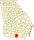
| County | Lowndes |
| Founded | 1825 |
| Elevation | 174 ft (53 m) |
| Time zone | UTC-5 (Eastern (EST)) |
| • Summer (DST) | UTC-4 (EDT) |
| ZIP Code | 31636 |
| Area code | 229 |
Twin Lakes is an unincorporated community in Lowndes County, in the U.S. state of Georgia. [1]