History
Macon County was created in 1837 from parts of Houston ("house-ton") and Marion counties, effective December 14 of that year. The 91st county, it was named for the then-recently deceased General Nathaniel Macon [4] of North Carolina, who served in the U.S. Congress for 37 years and ran for U.S. vice president. The city of Macon, Georgia was also named for him, but the city of Macon, Georgia, is the seat of Bibb County, a different county. The county was later reduced when parts were separated to organize Taylor and Peach counties, in 1852 and 1924, respectively.
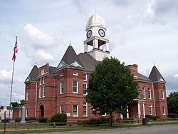
The first county seat was not chosen until 1838, when the county's inferior court selected Lanier. The Georgia General Assembly (state legislature) designated it on December 29 of that year and incorporated it as a town.
In the 1850s, the Central of Georgia Railroad was built through Oglethorpe, changing county dynamics. As a result, the Georgia Assembly called for a referendum on moving the Macon County seat to Oglethorpe in February of both 1854 and 1856. Little is known about the first vote, but the second vote resulted in approval for a change to the county seat, and Oglethorpe was designated the following year in 1857.
During the Civil War, 13,000 Union soldiers who were prisoners of war died at the Confederate camp in Andersonville, Georgia from starvation and disease. In the late period of the war, Georgia also had difficulty supplying its own troops and people with food. Throughout the Civil War, more men on both sides died of disease than of their wounds. Commandants of the camp were prosecuted after the war for poor treatment of prisoners. The Andersonville National Cemetery, established for the many Union dead, is at the southwestern tip of the county. [5]
The county has an active Mennonite community. The area code for Macon County is currently 478.
Geography
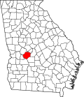
According to the U.S. Census Bureau, the county has a total area of 406 square miles (1,050 km2), of which 401 square miles (1,040 km2) is land and 5.4 square miles (14 km2) (1.3%) is water. [6] The county is located in the upper Atlantic coastal plain region of the state.
Most of the southern half of Macon County, from west of Ideal to State Route 49 north of Montezuma, then running north along State Route 49 to Marshallville, and then running southeast in the direction of Unadilla, is located in the Middle Flint River sub-basin of the ACF River Basin (Apalachicola-Chattahoochee-Flint River Basin). The northern and northwestern portion of the county, from north of Marshallville heading west, is located in the Upper Flint River sub-basin of the same ACF River Basin. The northeastern corner of Macon County, east of Marshallville, is located in the Lower Ocmulgee River sub-basin of the Altamaha River basin. [7]
Demographics
Historical population| Census | Pop. | Note | %± |
|---|
| 1840 | 5,045 | | — |
|---|
| 1850 | 7,052 | | 39.8% |
|---|
| 1860 | 8,449 | | 19.8% |
|---|
| 1870 | 11,458 | | 35.6% |
|---|
| 1880 | 11,675 | | 1.9% |
|---|
| 1890 | 13,183 | | 12.9% |
|---|
| 1900 | 14,093 | | 6.9% |
|---|
| 1910 | 15,016 | | 6.5% |
|---|
| 1920 | 17,667 | | 17.7% |
|---|
| 1930 | 16,643 | | −5.8% |
|---|
| 1940 | 15,947 | | −4.2% |
|---|
| 1950 | 14,213 | | −10.9% |
|---|
| 1960 | 13,170 | | −7.3% |
|---|
| 1970 | 12,933 | | −1.8% |
|---|
| 1980 | 14,003 | | 8.3% |
|---|
| 1990 | 13,114 | | −6.3% |
|---|
| 2000 | 14,074 | | 7.3% |
|---|
| 2010 | 14,740 | | 4.7% |
|---|
| 2020 | 12,082 | | −18.0% |
|---|
| 2024 (est.) | 11,831 | [8] | −2.1% |
|---|
|
Macon County, Georgia – Racial and ethnic composition
Note: the US Census treats Hispanic/Latino as an ethnic category. This table excludes Latinos from the racial categories and assigns them to a separate category. Hispanics/Latinos may be of any race.| Race / Ethnicity (NH = Non-Hispanic) | Pop 2000 [19] | Pop 2010 [17] | Pop 2020 [18] | % 2000 | % 2010 | % 2020 |
|---|
| White alone (NH) | 5,184 | 4,961 | 4,078 | 36.83% | 33.66% | 33.75% |
| Black or African American alone (NH) | 8,337 | 8,902 | 7,150 | 59.24% | 60.39% | 59.18% |
| Native American or Alaska Native alone (NH) | 26 | 19 | 15 | 0.18% | 0.13% | 0.12% |
| Asian alone (NH) | 82 | 190 | 156 | 0.58% | 1.29% | 1.29% |
| Native Hawaiian or Pacific Islander alone (NH) | 0 | 18 | 7 | 0.00% | 0.12% | 0.06% |
| Other race alone (NH) | 9 | 5 | 20 | 0.06% | 0.03% | 0.17% |
| Mixed race or Multiracial (NH) | 72 | 118 | 184 | 0.51% | 0.80% | 1.52% |
| Hispanic or Latino (any race) | 364 | 527 | 472 | 2.59% | 3.58% | 3.91% |
| Total | 14,074 | 14,740 | 12,082 | 100.00% | 100.00% | 100.00% |
2020 census
As of the 2020 census, the county had a population of 12,082, 4,299 households, and 3,033 families, and the median age was 41.7 years. [20] [21]
17.7% of residents were under the age of 18 and 19.0% were 65 years of age or older, with 118.6 males for every 100 females and 122.5 males for every 100 females age 18 and over. 0.0% of residents lived in urban areas, while 100.0% lived in rural areas. [20]
The racial makeup of the county was 34.4% White, 59.3% Black or African American, 0.3% American Indian and Alaska Native, 1.3% Asian, 0.1% Native Hawaiian and Pacific Islander, 2.7% from some other race, and 2.0% from two or more races. Hispanic or Latino residents of any race comprised 3.9% of the population. [22]
There were 4,299 households, of which 27.1% had children under the age of 18 living with them and 38.9% had a female householder with no spouse or partner present. About 34.0% of all households were made up of individuals and 15.5% had someone living alone who was 65 years of age or older. [21]
There were 5,109 housing units, of which 15.9% were vacant. Among occupied housing units, 64.4% were owner-occupied and 35.6% were renter-occupied. The homeowner vacancy rate was 1.0% and the rental vacancy rate was 8.9%. [21]
This page is based on this
Wikipedia article Text is available under the
CC BY-SA 4.0 license; additional terms may apply.
Images, videos and audio are available under their respective licenses.