Marshallville, Georgia

Last updated

Marshallville, Georgia
Macon County Georgia Incorporated and Unincorporated areas Marshallville Highlighted.svg
Location in Macon County and the state of Georgia
Coordinates: 32°27′12″N83°56′32″W / 32.45333°N 83.94222°W / 32.45333; -83.94222
Country United States
State Georgia
County Macon
Area
[1]
  Total3.16 sq mi (8.18 km2)
  Land3.12 sq mi (8.09 km2)
  Water0.03 sq mi (0.08 km2)
Elevation
515 ft (157 m)
Population
 (2020) [2]
  Total1,048
  Density335.47/sq mi (129.52/km2)
Time zone UTC-5 (Eastern (EST))
  Summer (DST) UTC-4 (EDT)
ZIP code
31057
Area code 478
FIPS code 13-49924 [3]
GNIS feature ID0356378 [4]
Website www.cityofmarshallville.org

Marshallville is a city in Macon County, Georgia, United States. The population was 1,048 at the 2020 census, [2] down from 1,448 in 2010.

Contents

History

Marshallville was founded in the 1820s. [5] It was incorporated as a town in 1854 and as a city in 1953. [6]

Geography

Marshallville is in northeastern Macon County. Georgia State Routes 49 and 127 pass through the city. SR 49 leads southwest 13 miles (21 km) to Montezuma, the largest city in the county, and north 8 miles (13 km) to Fort Valley. SR 127 goes southwest out of town with SR 49 but then leads west 21 miles (34 km) to Rupert, while to the east it leads 13 miles (21 km) to Perry.

According to the United States Census Bureau, Marshallville has a total area of 3.2 square miles (8.3 km2), of which 0.03 square miles (0.08 km2), or 1.01%, are water. [1]

Demographics

Historical population
CensusPop.Note
1870 424
1880 54328.1%
1890 1,086100.0%
1900 879−19.1%
1910 1,08223.1%
1920 1,1506.3%
1930 931−19.0%
1940 905−2.8%
1950 1,12123.9%
1960 1,30816.7%
1970 1,3765.2%
1980 1,54011.9%
1990 1,457−5.4%
2000 1,335−8.4%
2010 1,4488.5%
2020 1,048−27.6%
U.S. Decennial Census [7]
1850-1870 [8] 1880 [9]
1890-1910 [10] 1920-1930 [11]
1930-1940 [12] 1940-1950 [13]
1960-1980 [14] 1990 [15]
Marshallville racial composition as of 2020 [16]
RaceNum.Perc.
White (non-Hispanic)20019.08%
Black or African American (non-Hispanic)81477.67%
Native American 10.1%
Asian 10.1%
Pacific Islander 10.1%
Other/Mixed 171.62%
Hispanic or Latino 141.34%

As of the 2020 United States census, there were 1,048 people, 560 households, and 309 families residing in the city.

Related Research Articles

<span class="mw-page-title-main">Macon County, Georgia</span> County in Georgia, United States

Macon County is a county located in the west central portion of the U.S. state of Georgia. As of the 2020 census, the population was 12,082. The county seat is Oglethorpe.

<span class="mw-page-title-main">Keysville, Georgia</span> Town in Georgia, United States

Keysville is a town in Burke and Jefferson counties in the U.S. state of Georgia. As of the 2020 census, the city's population was 300.

<span class="mw-page-title-main">Trenton, Georgia</span> City in Georgia, United States

Trenton is a city and the only incorporated municipality in Dade County, Georgia, United States—and as such, it serves as the county seat. The population was 2,195 at the 2020 census. Trenton is part of the Chattanooga, Tennessee–GA Metropolitan Statistical Area.

<span class="mw-page-title-main">Chester, Georgia</span> Town in Georgia, United States

Chester is a town in Dodge County, Georgia, United States. The population was 1,596 at the 2010 census, up from 305 in 2000, due to inclusion of Dodge State Prison within the town limits. By 2020, its township population was 525.

<span class="mw-page-title-main">Bellville, Georgia</span> City in Georgia, United States

Bellville is a city in Evans County, Georgia, United States. As of the 2020 census, the city had a population of 127. It is the hometown of film director James Kicklighter.

<span class="mw-page-title-main">Mitchell, Georgia</span> Town in Georgia, United States

Mitchell is a town in Glascock County, Georgia, United States. The population was 199 at the 2010 census, and 153 in 2020. Mitchell is home to the Mitchell Depot Historical Museum.

<span class="mw-page-title-main">Wrightsville, Georgia</span> City in Georgia, United States

Wrightsville is a city in and the county seat of Johnson County, Georgia, United States. The population was 2,195 at the 2010 census, down from 2,223 at the 2000 census. By 2020, its population grew to 3,449. The city limits include Johnson State Prison on the northeast side of town. Wrightsville is part of the Dublin Micropolitan Statistical Area.

<span class="mw-page-title-main">Aldora, Georgia</span> Town in Georgia, United States

Aldora is a town in Lamar County, Georgia, United States. As of the 2020 census, the city had a recorded population of 0, due to a "0 percent self-response rate" to the 2020 census. The actual population was estimated at 103.

<span class="mw-page-title-main">Barnesville, Georgia</span> City in Georgia, United States

Barnesville is a city in Lamar County, Georgia, United States. As of the 2010 census, the city had a population of 6,755, up from 5,972 at the 2000 census. The city is the county seat of Lamar County and is part of the Atlanta metropolitan area.

<span class="mw-page-title-main">Milner, Georgia</span> City in Georgia, United States

Milner is a city in Lamar County, Georgia, United States. The population was 610 at the 2010 census, up from 522 at the 2000 census.

<span class="mw-page-title-main">Ideal, Georgia</span> City in Georgia, United States

Ideal is a city in Macon County, Georgia, United States. The population was 407 at the 2020 census, down from 499 in 2010.

<span class="mw-page-title-main">Montezuma, Georgia</span> City in Georgia, United States

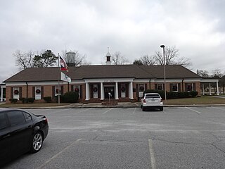
Montezuma is a city in Macon County, Georgia. The population was 3,047 at the 2020 census, down from 3,460 in 2010. It is home to the armory of Bravo Company, 648th Engineers of the Georgia Army National Guard.

<span class="mw-page-title-main">Oglethorpe, Georgia</span> City in Georgia, United States

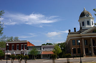
Oglethorpe is a city in Macon County, Georgia, United States. The population was 995 at the 2020 census, down from 1,328 in 2010. The city is the county seat of Macon County. It was named for Georgia's founder, James Oglethorpe.

<span class="mw-page-title-main">Ila, Georgia</span> City in Georgia, United States

Ila is a city in Madison County, Georgia, United States. The population was 350 at the 2020 census.

<span class="mw-page-title-main">Mount Vernon, Georgia</span> City in Georgia, United States

Mount Vernon is a city in, and the county seat of, Montgomery County, Georgia, United States. The population was 1,900 at the 2020 census, down from 2,451 in 2010. It is home to Brewton–Parker College.

<span class="mw-page-title-main">Junction City, Georgia</span> Town in Georgia, United States

Junction City is a town in Talbot County, Georgia, United States. The population was 179 at the 2000 census.

<span class="mw-page-title-main">Thomaston, Georgia</span> City in Georgia, United States

Thomaston is a city in and the county seat of Upson County, Georgia, United States. The population was 9,170 at the 2010 census. It is the principal city of and is included in the Thomaston, Georgia Micropolitan Statistical Area, which is included in the Atlanta - Sandy Springs (GA) - Gainesville (GA) - Alabama (partial) Combined Statistical Area.

<span class="mw-page-title-main">Yatesville, Georgia</span> Town in Georgia, United States

Yatesville is a town in Upson County, Georgia, United States. The population was 408 at the 2000 census.

<span class="mw-page-title-main">McIntyre, Georgia</span> Town in Georgia, United States

McIntyre is a town in Wilkinson County, Georgia, United States. The population was 575 in 2020.

<span class="mw-page-title-main">Abbeville, Georgia</span> City in Georgia, United States

Abbeville is a city in Wilcox County, Georgia, United States. Per the 2020 census, the population was 2,685. The city is the county seat of Wilcox County.

References

  1. 1 2 "2022 U.S. Gazetteer Files: Georgia". United States Census Bureau. Retrieved January 19, 2023.
  2. 1 2 "P1. Race – Marshallville city, Georgia: 2020 DEC Redistricting Data (PL 94-171)". U.S. Census Bureau. Retrieved January 19, 2023.
  3. "U.S. Census website". United States Census Bureau . Retrieved January 31, 2008.
  4. "US Board on Geographic Names". United States Geological Survey. October 25, 2007. Retrieved January 31, 2008.
  5. Krakow, Kenneth K. (1975). Georgia Place-Names: Their History and Origins (PDF). Macon, GA: Winship Press. p. 144. ISBN   0-915430-00-2.
  6. Hellmann, Paul T. (May 13, 2013). Historical Gazetteer of the United States. Routledge. p. 238. ISBN   978-1135948597 . Retrieved November 30, 2013.
  7. "Decennial Census of Population and Housing by Decades". US Census Bureau.
  8. "1870 Census of Population - Georgia" (PDF). US Census Bureau . 1870.
  9. "1880 Census of Population - Georgia" (PDF). US Census Bureau . 1880.
  10. "1910 Census of Population - Georgia" (PDF). US Census Bureau . 1930.
  11. "1930 Census of Population - Georgia" (PDF). US Census Bureau . 1930. p. 253.
  12. "1940 Census of Population - Georgia" (PDF). US Census Bureau . 1940.
  13. "1950 Census of Population - Georgia" (PDF). US Census Bureau . 1980.
  14. "1980 Census of Population - Number of Inhabitants - Georgia" (PDF). US Census Bureau . 1980.
  15. "1990 Census of Population - General Population Characteristics - Georgia" (PDF). US Census Bureau . 1990.
  16. "Explore Census Data". data.census.gov. Retrieved December 18, 2021.