Ideal, Georgia

Last updated

Ideal, Georgia
Macon County Georgia Incorporated and Unincorporated areas Ideal Highlighted.svg
Location in Macon County and the state of Georgia
Coordinates: 32°22′23″N84°11′20″W / 32.37306°N 84.18889°W / 32.37306; -84.18889
Country United States
State Georgia
County Macon
Area
[1]
  Total
1.15 sq mi (2.99 km2)
  Land1.14 sq mi (2.96 km2)
  Water0.01 sq mi (0.03 km2)
Elevation
482 ft (147 m)
Population
 (2020) [2]
  Total
407
  Density355.77/sq mi (137.34/km2)
Time zone UTC-5 (Eastern (EST))
  Summer (DST) UTC-4 (EDT)
ZIP code
31041
Area code 478
FIPS code 13-40812 [3]
GNIS feature ID0356328 [4]

Ideal is a city in Macon County, Georgia, United States. The population was 407 at the 2020 census, [2] down from 499 in 2010.

Contents

History

The town was originally named "Joetown", but when two railroad executives stopped in the town, one proclaimed it an "ideal" place for a railroad station, and the other declared he'd just named it. [5]

The Georgia General Assembly incorporated Ideal as a town in 1906. [6]

Geography

Ideal is located in western Macon County at 32°22′23″N84°11′20″W / 32.37306°N 84.18889°W / 32.37306; -84.18889 (32.372918, -84.188822). [7] Georgia State Route 90 passes through the center of town, leading southeast 10 miles (16 km) to Oglethorpe, the county seat, and northwest 8 miles (13 km) to Rupert.

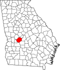
According to the United States Census Bureau, the city has a total area of 1.16 square miles (3.0 km2), of which 0.01 square miles (0.03 km2), or 0.95%, are water. [1] It resides at the confluence of Whitewater and Cedar creeks, two spring-fed tributaries of the Flint River.

Demographics

Historical population
CensusPop.Note
1910 186
1920 30463.4%
1930 285−6.2%
1940 238−16.5%
1950 31833.6%
1960 43235.8%
1970 54325.7%
1980 61914.0%
1990 554−10.5%
2000 518−6.5%
2010 499−3.7%
2020 407−18.4%
U.S. Decennial Census [8]
1850-1870 [9] 1880 [10]
1890-1910 [11] 1920-1930 [12]
1930-1940 [13] 1940-1950 [14]
1960-1980 [15] 1990 [16]
Ideal racial composition as of 2020 [17]
RaceNum.Perc.
White (non-Hispanic)11327.76%
Black or African American (non-Hispanic)27066.34%
Asian 10.25%
Other/Mixed 215.16%
Hispanic or Latino 20.49%

As of the 2020 United States census, there were 407 people, 124 households, and 64 families residing in the city.

References

  1. 1 2 "2022 U.S. Gazetteer Files: Georgia". United States Census Bureau. Retrieved January 18, 2023.
  2. 1 2 "P1. Race – Ideal city, Georgia: 2020 DEC Redistricting Data (PL 94-171)". U.S. Census Bureau. Retrieved January 18, 2023.
  3. "U.S. Census website". United States Census Bureau . Retrieved January 31, 2008.
  4. "US Board on Geographic Names". United States Geological Survey. October 25, 2007. Retrieved January 31, 2008.
  5. Krakow, Kenneth K. (1975). Georgia Place-Names: Their History and Origins (PDF). Macon, GA: Winship Press. p. 115. ISBN   0-915430-00-2.
  6. Georgia (1907). Acts and Resolutions of the General Assembly of the State of Georgia. Clark & Hines, State Printers. p. 730.
  7. "US Gazetteer files: 2010, 2000, and 1990". United States Census Bureau. February 12, 2011. Retrieved April 23, 2011.
  8. "Decennial Census of Population and Housing by Decades". US Census Bureau.
  9. "1870 Census of Population - Georgia" (PDF). US Census Bureau . 1870.
  10. "1880 Census of Population - Georgia" (PDF). US Census Bureau . 1880.
  11. "1910 Census of Population - Georgia" (PDF). US Census Bureau . 1930. Archived from the original (PDF) on January 16, 2024.
  12. "1930 Census of Population - Georgia" (PDF). US Census Bureau . 1930. p. 253.
  13. "1940 Census of Population - Georgia" (PDF). US Census Bureau . 1940.
  14. "1950 Census of Population - Georgia" (PDF). US Census Bureau . 1980.
  15. "1980 Census of Population - Number of Inhabitants - Georgia" (PDF). US Census Bureau . 1980.
  16. "1990 Census of Population - General Population Characteristics - Georgia" (PDF). US Census Bureau . 1990.
  17. "Explore Census Data". data.census.gov. Retrieved December 18, 2021.