Greene County | |
---|---|
Coordinates: 33°35′N83°10′W / 33.58°N 83.17°W | |
Country | United States |
State | Georgia |
Founded | 1786 |
Named for | Nathanael Greene |
Seat | Greensboro |
Largest city | Greensboro |
Area | |
• Total | 406 sq mi (1,050 km2) |
• Land | 387 sq mi (1,000 km2) |
• Water | 19 sq mi (50 km2) 4.6% |
Population (2020) | |
• Total | 18,915 [1] |
• Density | 49/sq mi (19/km2) |
Time zone | UTC−5 (Eastern) |
• Summer (DST) | UTC−4 (EDT) |
Congressional district | 10th |
Website | www |
Greene County is a county located in the east central portion & the Lake country region of the U.S. state of Georgia. As of the 2020 census, the population was 18,915. [2] The county seat is Greensboro. [3] The county was created on February 3, 1786, and is named for Nathanael Greene, an American Revolutionary War major general.
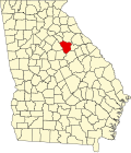
Greene County was formed on February 3, 1786, from land given by Washington County. [4] It was named in honor of General Nathanael Greene, a hero of the American Revolutionary War. [5]
According to the U.S. Census Bureau, the county has a total area of 406 square miles (1,050 km2), of which 387 square miles (1,000 km2) is land and 19 square miles (49 km2) (4.6%) is water. [6]
The majority of Greene County, west of a line between Woodville, Union Point, and White Plains, is located in the Upper Oconee River sub-basin of the Altamaha River basin. The northern half of the remainder of the county is located in the Little River sub-basin of the Savannah River basin, while the southern half is located in the Upper Ogeechee River sub-basin of the Ogeechee River basin. [7]
Census | Pop. | Note | %± |
---|---|---|---|
1790 | 5,405 | — | |
1800 | 10,761 | 99.1% | |
1810 | 11,679 | 8.5% | |
1820 | 13,589 | 16.4% | |
1830 | 12,549 | −7.7% | |
1840 | 11,690 | −6.8% | |
1850 | 13,068 | 11.8% | |
1860 | 12,652 | −3.2% | |
1870 | 12,454 | −1.6% | |
1880 | 17,547 | 40.9% | |
1890 | 17,051 | −2.8% | |
1900 | 16,542 | −3.0% | |
1910 | 18,512 | 11.9% | |
1920 | 18,972 | 2.5% | |
1930 | 12,616 | −33.5% | |
1940 | 13,709 | 8.7% | |
1950 | 12,843 | −6.3% | |
1960 | 11,193 | −12.8% | |
1970 | 10,212 | −8.8% | |
1980 | 11,391 | 11.5% | |
1990 | 11,793 | 3.5% | |
2000 | 14,406 | 22.2% | |
2010 | 15,994 | 11.0% | |
2020 | 18,915 | 18.3% | |
2023 (est.) | 20,722 | [8] | 9.6% |
U.S. Decennial Census [9] 1790-1880 [10] 1890-1910 [11] 1920-1930 [12] 1930-1940 [13] 1940-1950 [14] 1960-1980 [15] 1980-2000 [16] 2010 [17] 2020 [1] |
Race | Num. | Perc. |
---|---|---|
White (non-Hispanic) | 11,126 | 58.82% |
Black or African American (non-Hispanic) | 5,783 | 30.57% |
Native American | 28 | 0.15% |
Asian | 174 | 0.92% |
Pacific Islander | 2 | 0.01% |
Other/Mixed | 513 | 2.71% |
Hispanic or Latino | 1,289 | 6.81% |
As of the 2020 United States census, there were 18,915 people, 7,132 households, and 4,975 families residing in the county.
The county supports the Greene County School Board, Lake Oconee Academy and Nathanael Greene Academy.
In 2001, Georgia Supreme Court Chief Justice Robert Benham convened a committee to investigate indigent defense in the state of Georgia. An avalanche of complaints about the state of public defense in Greene County, along with a number of lawsuits filed by Stephen Bright and the Southern Center for Human Rights, contributed to the formation of this commission. The commission discovered during its investigation that indigent defendants in Greene County were routinely pleaded guilty by judges without the presence of counsel and sometimes without even being present in court to make their pleas, violations of the Sixth Amendment. Excessive bail, e.g. $50,000 for loitering, was often set as well, a violation of the Eighth Amendment. After two years of investigation, the committee's recommendations led to the passage of the Georgia Indigent Defense Act. [19] [20]
Prior to 2000, the only time Greene County failed to back a Democratic Party candidate in a presidential election was in 1972, when Richard Nixon won every county in Georgia and all but 130 counties nationwide. From 2000 onward, it has been consistently Republican. Mainly due to the growth of white residents moving to Reynolds Lake Oconee.
Year | Republican | Democratic | Third party | |||
---|---|---|---|---|---|---|
No. | % | No. | % | No. | % | |
2020 | 7,066 | 62.83% | 4,087 | 36.34% | 94 | 0.84% |
2016 | 5,490 | 61.55% | 3,199 | 35.87% | 230 | 2.58% |
2012 | 5,071 | 60.90% | 3,201 | 38.44% | 55 | 0.66% |
2008 | 4,532 | 57.21% | 3,339 | 42.15% | 50 | 0.63% |
2004 | 4,069 | 59.17% | 2,774 | 40.34% | 34 | 0.49% |
2000 | 2,980 | 57.34% | 2,137 | 41.12% | 80 | 1.54% |
1996 | 1,702 | 42.39% | 2,115 | 52.68% | 198 | 4.93% |
1992 | 1,307 | 32.21% | 2,259 | 55.67% | 492 | 12.12% |
1988 | 1,432 | 43.93% | 1,818 | 55.77% | 10 | 0.31% |
1984 | 1,599 | 44.53% | 1,992 | 55.47% | 0 | 0.00% |
1980 | 961 | 26.90% | 2,571 | 71.96% | 41 | 1.15% |
1976 | 652 | 20.46% | 2,534 | 79.54% | 0 | 0.00% |
1972 | 1,679 | 64.63% | 919 | 35.37% | 0 | 0.00% |
1968 | 652 | 18.58% | 1,635 | 46.58% | 1,223 | 34.84% |
1964 | 1,093 | 28.83% | 2,698 | 71.17% | 0 | 0.00% |
1960 | 328 | 14.22% | 1,979 | 85.78% | 0 | 0.00% |
1956 | 541 | 21.19% | 2,012 | 78.81% | 0 | 0.00% |
1952 | 397 | 14.60% | 2,323 | 85.40% | 0 | 0.00% |
1948 | 92 | 5.79% | 1,213 | 76.29% | 285 | 17.92% |
1944 | 144 | 10.33% | 1,246 | 89.38% | 4 | 0.29% |
1940 | 148 | 8.93% | 1,497 | 90.29% | 13 | 0.78% |
1936 | 86 | 5.96% | 1,348 | 93.35% | 10 | 0.69% |
1932 | 52 | 5.35% | 918 | 94.44% | 2 | 0.21% |
1928 | 245 | 28.10% | 627 | 71.90% | 0 | 0.00% |
1924 | 77 | 9.86% | 558 | 71.45% | 146 | 18.69% |
1920 | 178 | 20.72% | 681 | 79.28% | 0 | 0.00% |
1916 | 153 | 17.35% | 676 | 76.64% | 53 | 6.01% |
1912 | 150 | 21.90% | 525 | 76.64% | 10 | 1.46% |
Putnam County is a county located in the central portion of the U.S. state of Georgia. As of the 2020 census, the population was 22,047. The county seat is Eatonton.
Wheeler County is a county located in the central portion of the U.S. state of Georgia. As of the 2020 census, the population was 7,471. The county seat is Alamo.
Washington County is a county located in the U.S. state of Georgia. As of the 2020 census, the population was 19,988. The county seat is Sandersville. The county was established on February 25, 1784. It was named for Revolutionary War general George Washington.
Warren County is a county located in the U.S. state of Georgia. As of the 2020 United States census, the population was 5,215, a decrease from 2010. The county seat is Warrenton. The county was created on December 19, 1793, and is named after General Joseph Warren, who was killed in the Battle of Bunker Hill.
Taliaferro County is a county located in East central Piedmont region of the U.S. state of Georgia. As of the 2020 census, the population was 1,559, down from the 2010 census when the population was 1,717, making it the least populous county in Georgia and the second least populous county east of the Mississippi River. The county seat is Crawfordville.
Screven County is a county located in the southeastern part of the U.S. state of Georgia. As of the 2020 census, the population was 14,067. The county seat is Sylvania.
Oglethorpe County is a county located in the northeastern part of the U.S. state of Georgia. As of the 2020 census, the population was 14,825. The county seat is Lexington.
Oconee County is a county located in the northeastern part of the U.S. state of Georgia. As of the 2020 census, the population was 41,799. The county seat is Watkinsville.
Morgan County is a county located in the north central Piedmont region and the lake country region of the U.S. state of Georgia. As of the 2020 census, the population was 20,097. The county seat is Madison.
Long County is a county located in the U.S. state of Georgia. The county seat is Ludowici. Long County is part of the Hinesville-Fort Stewart Metropolitan Statistical Area. The constitutional amendment to create the county was proposed August 14, 1920, and ratified November 2, 1920. The county is named after Crawford Long (1815–1878), an American surgeon and pharmacist who was the first to use diethyl ether as an anaesthetic.
Johnson County is a county located along the oconee River in the U.S. state of Georgia. As of the 2020 census, the population was 9,189. The county seat is Wrightsville. Johnson County is part of the Dublin, Georgia, micropolitan statistical area.
Jenkins County is a county located in the southeastern area of the U.S. state of Georgia. As of the 2020 census, the population was 8,674. The county seat is Millen. Historic and bountiful Magnolia Springs State Park is located between Millen and Perkins.
Jefferson County is a county located in the U.S. state of Georgia. As of the 2020 census, the population was 15,709. The county seat and largest city is Louisville. The county was created on February 20, 1796, and named for Thomas Jefferson, the main author of the Declaration of Independence who became the third president of the United States.
Hancock County is a county located in the East Central part of the U.S. state of Georgia. As of the 2020 census, the population was 8,735. The county seat is Sparta. The county was created on December 17, 1793, and named for John Hancock, a Founding Father of the American Revolution.
Glascock County is a county located in the U.S. state of Georgia. As of the 2020 census, the population was 2,884, making it the fourth-least populous county in Georgia. The county seat is Gibson. The county was created on December 19, 1857.
Emanuel County is a county located in the magnolia midlands portion of the U.S. state of Georgia. As of the 2020 census, the population was 22,768. The county seat is Swainsboro.
Clarke County is located in the northeastern part of the U.S. state of Georgia. As of the 2020 census, the population was 128,671. Its county seat is Athens, with which it is a consolidated city-county. Clarke County is included in the Athens-Clarke County, GA Metropolitan Statistical Area, which is also included in the Atlanta-Athens-Clarke County-Sandy Springs, GA Combined Statistical Area.
Candler County is a county located in the southeastern part of the U.S. state of Georgia. As of the 2020 census, the population was 10,981. The county seat is Metter. The county was founded in 1914 and named for Allen D. Candler, the 56th governor of Georgia.
Bryan County is a county located in the U.S. state of Georgia. As of the 2020 census, the population was 44,738. The county seat is Pembroke.
Bulloch County is a county located in the southeastern part of the U.S. state of Georgia. As of the 2020 census, the population was 81,099, up from 70,217 in 2010. The county seat is Statesboro. With Evans County, Bulloch forms part of the Statesboro micropolitan statistical area, a component of the Savannah–Hinesville–Statesboro combined statistical area.