White Plains, Georgia | |
---|---|
Coordinates: 33°28′37″N83°2′18″W / 33.47694°N 83.03833°W | |
Country | United States |
State | Georgia |
County | Greene |
Area | |
• Total | 5.21 sq mi (13.50 km2) |
• Land | 5.17 sq mi (13.38 km2) |
• Water | 0.05 sq mi (0.13 km2) |
Elevation | 690 ft (211 m) |
Population (2020) | |
• Total | 239 |
• Density | 46.27/sq mi (17.87/km2) |
Time zone | UTC-5 (Eastern (EST)) |
• Summer (DST) | UTC-4 (EDT) |
ZIP code | 30678 |
Area code | 706 |
FIPS code | 13-82692 [2] |
GNIS feature ID | 0356635 [3] |
White Plains is a city in Greene County, Georgia, United States. The population was 284 at the 2010 census. [4]
The Georgia General Assembly incorporated White Plains in 1834. [5] According to tradition, White Plains was so named on account of the local white sandy soil. [6]
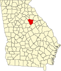
White Plains is located in southeastern Greene County at 33°28′37″N83°2′18″W / 33.47694°N 83.03833°W (33.477002, -83.038404). [7] The southeast border of the city follows the Hancock County line. Georgia State Route 15 (Old Greensboro Road) passes through the center of town, leading north 6 miles (9.7 km) to Siloam and south 15 miles (24 km) to Sparta. Greensboro, the Greene County seat, is 12 miles (19 km) to the northwest via State Route 15.
According to the United States Census Bureau, White Plains has a total area of 4.7 square miles (12.2 km2), of which 0.04 square miles (0.1 km2), or 1.02%, is water. [4]
Census | Pop. | Note | %± |
---|---|---|---|
1870 | 374 | — | |
1880 | 459 | 22.7% | |
1890 | 510 | 11.1% | |
1900 | 290 | −43.1% | |
1910 | 407 | 40.3% | |
1920 | 479 | 17.7% | |
1930 | 406 | −15.2% | |
1940 | 364 | −10.3% | |
1950 | 359 | −1.4% | |
1960 | 273 | −24.0% | |
1970 | 236 | −13.6% | |
1980 | 231 | −2.1% | |
1990 | 286 | 23.8% | |
2000 | 283 | −1.0% | |
2010 | 284 | 0.4% | |
2020 | 239 | −15.8% | |
U.S. Decennial Census [8] 1850-1870 [9] 1870-1880 [10] 1890-1910 [11] 1920-1930 [12] 1940 [13] 1950 [14] 1960 [15] 1970 [16] 1980 [17] 1990 [18] 2000 [19] 2010 [20] 2020 [21] |
Race / Ethnicity | Pop 2000 [22] | Pop 2010 [20] | Pop 2020 [21] | % 2000 | % 2010 | % 2020 |
---|---|---|---|---|---|---|
White alone (NH) | 150 | 167 | 152 | 53.00% | 58.80% | 63.60% |
Black or African American alone (NH) | 124 | 115 | 74 | 43.82% | 40.49% | 30.96% |
Native American or Alaska Native alone (NH) | 0 | 0 | 0 | 0.00% | 0.00% | 0.00% |
Asian alone (NH) | 0 | 0 | 0 | 0.00% | 0.00% | 0.00% |
Pacific Islander alone (NH) | 0 | 0 | 0 | 0.00% | 0.00% | 0.00% |
Some Other Race alone (NH) | 0 | 0 | 1 | 0.00% | 0.00% | 0.42% |
Mixed Race/Multi-Racial (NH) | 0 | 1 | 7 | 0.00% | 0.35% | 2.93% |
Hispanic or Latino (any race) | 9 | 1 | 5 | 3.18% | 0.35% | 2.09% |
Total | 283 | 284 | 239 | 100.00% | 100.00% | 100.00% |
As of the census [2] of 2000, there were 283 people, 108 households, and 72 families residing in the city. The population density was 61.5 inhabitants per square mile (23.7/km2). There were 126 housing units at an average density of 27.4 per square mile (10.6/km2). The racial makeup of the city was 55.83% White and 44.17% African American. Hispanic or Latino of any race were 3.18% of the population.
There were 108 households, out of which 32.4% had children under the age of 18 living with them, 41.7% were married couples living together, 23.1% had a female householder with no husband present, and 33.3% were non-families. 26.9% of all households were made up of individuals, and 13.9% had someone living alone who was 65 years of age or older. The average household size was 2.62 and the average family size was 3.28.
In the city, the population was spread out, with 25.8% under the age of 18, 9.9% from 18 to 24, 31.1% from 25 to 44, 21.9% from 45 to 64, and 11.3% who were 65 years of age or older. The median age was 35 years. For every 100 females, there were 87.4 males. For every 100 females age 18 and over, there were 85.8 males.
The median income for a household in the city was $33,906, and the median income for a family was $36,136. Males had a median income of $22,143 versus $15,781 for females. The per capita income for the city was $12,328. About 16.3% of families and 24.6% of the population were below the poverty line, including 36.6% of those under the age of eighteen and 20.9% of those 65 or over.
Clay County is a county located in the southwestern part of the U.S. state of Georgia. As of the 2020 census, the population was 2,848, making it the fourth-least populous county in Georgia. The county seat is Fort Gaines.
Chambers County is a county located in the east central portion of the U.S. state of Alabama. As of the 2020 census the population was 34,772. Its county seat is LaFayette. Its largest city is Valley. Its name is in honor of Henry H. Chambers, who served as a United States Senator from Alabama.
Cleburne County is a county located in the east central portion of the U.S. state of Alabama. As of the 2020 census, the population was 15,056. Its county seat is Heflin. Its name is in honor of Patrick R. Cleburne of Arkansas who rose to the rank of major general in the Confederate States Army. The eastern side of the county borders the state of Georgia.
Cochran County is a county located in the U.S. state of Texas. As of the 2020 census, its population was 2,547. The county seat is Morton. The county was created in 1876 and later organized in 1924. It is named for Robert E. Cochran, a defender of the Alamo.
Habersham County is a county located in the northeastern part of the U.S. state of Georgia. As of the 2020 census, the population was 46,031. The county seat is Clarkesville. The county was created on December 15, 1818, and named for Colonel Joseph Habersham of the Continental Army in the Revolutionary War.
Burke County is a county located along the eastern border of the U.S. state of Georgia in the Piedmont. As of the 2020 census, the population was 24,596. The county seat is Waynesboro. Burke County is part of the Augusta-Richmond County, GA-SC metropolitan statistical area.
Barrow County is a county located in the north central portion of the U.S. state of Georgia. As of the 2020 census, the population was 83,505. The county seat is Winder. Barrow County is included in the Atlanta-Sandy Springs-Roswell metropolitan statistical area.
Greenville is a town in Madison County, Florida, United States. The population was 746 at the 2020 census, down from 843 at the 2010 census.
Vinings is an unincorporated community and census-designated place (CDP) in Cobb County, Georgia, United States that runs along the Chattahoochee River bank across from Buckhead. As of the 2020 census, the CDP had a total population of 12,581. Located next to the affluent Paces section of Buckhead in northwest Atlanta, Vinings is known for its historic sites, shopping districts, proximity to local freeways and The Battery, and nearby nature areas. The United States Postal Service assigns "Atlanta" to the ZIP Code (30339) that includes Vinings.
Gresham Park is an unincorporated community and census-designated place (CDP) in DeKalb County, Georgia, United States. The population was 7,700 at the 2020 census.
Union City is a city in Fulton County, Georgia, United States. The population was 26,830 at the 2020 census.
Siloam is a town in Greene County, Georgia, United States. The population was 282 at the 2010 census, down from 331 in 2000.
Union Point is a city in Greene County, Georgia, United States. As of the 2020 census, the city population was 1,597.
Woodville is a city in Greene County, Georgia, United States. The population was 321 at the 2010 census, down from 400 at the 2000 census.
Bostwick is a city in Morgan County, Georgia, United States. As of the 2020 census, the city had a population of 378.
Rutledge is a city in Morgan County, Georgia, United States. Founded in 1871, the city had a population of 871 at the 2020 census, up from 781 in 2010.
Plains is a city in Sumter County, Georgia, United States. The population was 573 at the 2020 census and it is a part of the Americus Micropolitan Statistical Area. It is well known as the birthplace of Jimmy Carter and his wife Rosalynn, who were the president and first lady of the United States from 1977 to 1981. They lived in Plains both before and after their time in the White House.
Phillipsburg is an unincorporated community and census-designated place (CDP) in Tift County, Georgia, United States. The population was 887 at the 2000 census.
Unionville is an unincorporated community and census-designated place (CDP) in Tift County, Georgia, United States. The population was 2,074 at the 2000 census.
Varnell is a city in Whitfield County, Georgia, United States. It is part of the Dalton, Georgia Metropolitan Statistical Area. The population was 2,179 at the 2020 census.