Bryan County, Georgia

Last updated

Bryan County
Bryan County Courthouse, Pembroke, GA, US.jpg
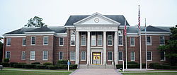
Bryan County Courthouse in Pembroke
Map of Georgia highlighting Bryan County.svg
Location within the U.S. state of Georgia
Georgia in United States.svg
Georgia's location within the U.S.
Coordinates: 32°01′N81°26′W / 32.02°N 81.44°W / 32.02; -81.44
CountryFlag of the United States.svg United States
StateFlag of Georgia (U.S. state).svg  Georgia
Founded1793;231 years ago (1793)
Named for Jonathan Bryan
Seat Pembroke
Largest city Richmond Hill
Area
  Total454 sq mi (1,180 km2)
  Land436 sq mi (1,130 km2)
  Water18 sq mi (50 km2)  4.1%
Population
 (2020)
  Total44,738
  Density103/sq mi (40/km2)
Time zone UTC−5 (Eastern)
  Summer (DST) UTC−4 (EDT)
Congressional district 1st
Website www.bryancountyga.org

Bryan County is a county located in the U.S. state of Georgia. As of the 2020 census, the population was 44,738. [1] The county seat is Pembroke. [2]

Contents

Bryan County is part of the Savannah, GA metropolitan statistical area.

The Bryan County Courthouse is listed on the National Register of Historic Places.

History

Bryan County was created on December 19, 1793, named after Jonathan Bryan (1708–1788), an American Revolutionary War partisan. [3]

South Bryan County is home to the earthen Civil War installation Fort McAllister (now Fort McAllister Historic Park) which Gen. William Sherman captured on his March to the Sea.

The colonial town of Hardwick, laid out in 1755, served as the initial county seat. In 1797, the Georgia General Assembly moved the county seat to Cross Roads near modern Richmond Hil. On November 18, 1814, the county seat was moved to Mansford on the Canoochee River. [4] In 1860, the seat was known as Eden. By the 1880s the county seat was known as Bryan. By 1895 it was in Clyde, which may have been the same location formerly known as Eden and Mansford. Clyde served as the seat to 1935; in 1937 Pembroke took on that role. The only remaining sign of Clyde is a cemetery on the Fort Stewart military reservation.

Geography

According to the U.S. Census Bureau, the county has a total area of 454 square miles (1,180 km2), of which 436 square miles (1,130 km2) is land and 18 square miles (47 km2) (4.1%) is water. [5]

A triangular area in the northeast of Bryan County, from northwest of Pembroke to north of Richmond Hill, is located in the Lower Ogeechee River sub-basin of the Ogeechee River basin, as is the northern half of the remaining area in the county south of Richmond Hill. The northwestern portion of the county, from east of Daisy to Richmond Hill, is located in the Canoochee River sub-basin of the Ogeechee River basin. The rest of Bryan County is located in the Ogeechee Coastal sub-basin of the same Ogeechee River basin. [6]

Bryan County is unique in that it is totally divided by the military installation at Ft. Stewart. Pembroke is in more rural north Bryan, while Richmond Hill in south Bryan County is a suburb of Savannah. To travel between the two on public roads, it is necessary to leave the county.

Major highways

Adjacent counties

Communities

Cities

Unincorporated communities

Demographics

Historical population
CensusPop.Note
1800 2,836
1810 2,827−0.3%
1820 3,0216.9%
1830 3,1393.9%
1840 3,1821.4%
1850 3,4247.6%
1860 4,01517.3%
1870 5,25230.8%
1880 4,929−6.2%
1890 5,52012.0%
1900 6,12210.9%
1910 6,7029.5%
1920 6,343−5.4%
1930 5,952−6.2%
1940 6,2885.6%
1950 5,965−5.1%
1960 6,2264.4%
1970 6,5395.0%
1980 10,17555.6%
1990 15,43851.7%
2000 23,41751.7%
2010 30,23329.1%
2020 44,73848.0%
2023 (est.)49,739 [7] 11.2%
U.S. Decennial Census [8]
1790-1880 [9] 1890-1910 [10]
1920-1930 [11] 1930-1940 [12]
1940-1950 [13] 1960-1980 [14]
1980-2000 [15] 2010 [16]
Bryan County racial composition as of 2020 [17]
RaceNum.Perc.
White (non-Hispanic)31,32170.01%
Black or African American (non-Hispanic)6,33014.15%
Native American 1020.23%
Asian 1,0322.31%
Pacific Islander 530.12%
Other/Mixed 2,6315.88%
Hispanic or Latino 3,2697.31%

As of the 2020 United States census, there were 44,738 people, 13,048 households, and 10,140 families residing in the county.

Education

Bryan County School District is the designated school district for grades K-12 for the county, except parts in Fort Stewart. Fort Stewart has the Department of Defense Education Activity (DoDEA) as its local school district, [18] for the elementary level. [19] Students at the secondary level on Fort Stewart attend public schools operated by county school districts. [20]

Politics

United States presidential election results for Bryan County, Georgia [21]
Year Republican Democratic Third party
No.%No.%No.%
2020 14,24066.70%6,73831.56%3711.74%
2016 10,52968.95%4,01426.29%7284.77%
2012 9,56070.94%3,70727.51%2091.55%
2008 9,11270.82%3,63628.26%1190.92%
2004 7,36373.67%2,59025.92%410.41%
2000 4,83568.49%2,17230.77%520.74%
1996 3,57757.06%2,15234.33%5408.61%
1992 2,78947.05%2,03134.26%1,10818.69%
1988 2,80266.16%1,42333.60%100.24%
1984 2,26561.83%1,39838.17%00.00%
1980 1,21237.47%1,96660.77%571.76%
1976 76127.12%2,04572.88%00.00%
1972 1,40984.27%26315.73%00.00%
1968 38116.08%56023.64%1,42860.28%
1964 1,43362.58%85737.42%00.00%
1960 42824.44%1,32375.56%00.00%
1956 33121.04%1,24278.96%00.00%
1952 33125.42%97174.58%00.00%
1948 1357.67%1,14765.21%47727.12%
1944 9011.57%68888.43%00.00%
1940 495.30%87494.49%20.22%
1936 639.01%63290.41%40.57%
1932 174.56%35394.64%30.80%
1928 15140.81%21959.19%00.00%
1924 94.33%19694.23%31.44%
1920 2110.71%17589.29%00.00%
1916 175.30%29591.90%92.80%
1912 11417.98%40063.09%12018.93%

Notable people

See also

Related Research Articles

<span class="mw-page-title-main">Washington County, Georgia</span> County in Georgia, United States

Washington County is a county located in the U.S. state of Georgia. As of the 2020 census, the population was 19,988. The county seat is Sandersville. The county was established on February 25, 1784. It was named for Revolutionary War general George Washington.

<span class="mw-page-title-main">Tattnall County, Georgia</span> County in Georgia, United States

Tattnall County is a county located in the southeast portion of the U.S. state of Georgia, located within the Magnolia Midlands, a part of the Historic South region. As of the 2020 census, the population was 22,842. The county seat is Reidsville. Tattnall County was created on December 5, 1801, from part of Montgomery County, Georgia by the Georgia General Assembly.

<span class="mw-page-title-main">McIntosh County, Georgia</span> County in Georgia, United States

McIntosh County is a county located in the U.S. state of Georgia. As of the 2020 census, the population was 10,975, a drop of 23.4 percent since the 2010 census. The county seat is Darien.

<span class="mw-page-title-main">Long County, Georgia</span> County in Georgia, United States

Long County is a county located in the U.S. state of Georgia. The county seat is Ludowici. Long County is part of the Hinesville-Fort Stewart Metropolitan Statistical Area. The constitutional amendment to create the county was proposed August 14, 1920, and ratified November 2, 1920. The county is named after Crawford Long (1815–1878), an American surgeon and pharmacist who was the first to use diethyl ether as an anaesthetic.

<span class="mw-page-title-main">Liberty County, Georgia</span> County in Georgia, United States

Liberty County is a county in the U.S. state of Georgia. As of the 2020 census, the population is 65,256. The county seat is Hinesville.

<span class="mw-page-title-main">Jenkins County, Georgia</span> County in Georgia, United States

Jenkins County is a county located in the southeastern area of the U.S. state of Georgia. As of the 2020 census, the population was 8,674. The county seat is Millen. Historic and bountiful Magnolia Springs State Park is located between Millen and Perkins.

<span class="mw-page-title-main">Glascock County, Georgia</span> County in Georgia, United States

Glascock County is a county located in the U.S. state of Georgia. As of the 2020 census, the population was 2,884, making it the fourth-least populous county in Georgia. The county seat is Gibson. The county was created on December 19, 1857.

<span class="mw-page-title-main">Evans County, Georgia</span> County in Georgia, United States

Evans County is a county in the southeastern portion of the U.S. state of Georgia. As of the 2020 census, the population was 10,774. The county seat is Claxton. A bill creating the county was passed in the Georgia General Assembly on August 11, 1914, and later, on November 3, 1914, an amendment was ratified by a vote of the people which formally created the county. Evans became part of the Statesboro micropolitan area in 2023, joining Bulloch County.

<span class="mw-page-title-main">Emanuel County, Georgia</span> County in Georgia, United States

Emanuel County is a county located in the magnolia midlands portion of the U.S. state of Georgia. As of the 2020 census, the population was 22,768. The county seat is Swainsboro.

<span class="mw-page-title-main">Effingham County, Georgia</span> County in Georgia, United States

Effingham County is a county located in the southeastern part of the U.S. state of Georgia. As of the 2020 census, the population was 64,769. The seat is Springfield.

<span class="mw-page-title-main">Chatham County, Georgia</span> County in Georgia, United States

Chatham County is located in the U.S. state of Georgia, on the state's Atlantic coast. The county seat and largest city is Savannah. One of the original counties of Georgia, Chatham County was created February 5, 1777, and is named after William Pitt, 1st Earl of Chatham.

<span class="mw-page-title-main">Candler County, Georgia</span> County in Georgia, United States

Candler County is a county located in the southeastern part of the U.S. state of Georgia. As of the 2020 census, the population was 10,981. The county seat is Metter. The county was founded in 1914 and named for Allen D. Candler, the 56th governor of Georgia.

<span class="mw-page-title-main">Bulloch County, Georgia</span> County in Georgia, United States

Bulloch County is a county located in the southeastern part of the U.S. state of Georgia. As of the 2020 census, the population was 81,099, up from 70,217 in 2010. The county seat is Statesboro. With Evans County, Bulloch forms part of the Statesboro micropolitan statistical area, a component of the Savannah–Hinesville–Statesboro combined statistical area.

<span class="mw-page-title-main">Pembroke, Georgia</span> City and County Seat in Georgia, United States

Pembroke is a city and county seat in Bryan County, Georgia, United States. As of the 2020 census, the population of the city was 2,513. It is located approximately 35 miles west of Savannah, Georgia, and approximately 20 miles south of Statesboro, Georgia. Pembroke is part of the Savannah metropolitan statistical area.

<span class="mw-page-title-main">Richmond Hill, Georgia</span> City in Georgia, United States

Richmond Hill is a city in Bryan County, Georgia, United States. The population was 16,633 at the 2020 U.S. census, an increase of almost 80% from the 2010 population of 9,281. Richmond Hill is part of the Savannah metropolitan statistical area.

<span class="mw-page-title-main">Hinesville, Georgia</span> City in Georgia, United States

Hinesville is a city and county seat of Liberty County, Georgia, United States, located on the Atlantic coastal plain. The population was 33,437 at the 2010 census and an estimated 33,273 in 2019. By 2020, its population was 34,891. It is the principal city of the Hinesville metropolitan area, which comprises all of Liberty County, including the Fort Stewart army installation, plus neighboring Long County.

<span class="mw-page-title-main">Canoochee River</span>

The Canoochee River is a 108-mile-long (174 km) river in southeastern Georgia in the United States. It is a tributary of the Ogeechee River, which flows to the Atlantic Ocean. In 1738 the Trustees of the colony mentioned the proposed house and ferry boat over the 'Cooanoochi River'.

<span class="mw-page-title-main">Georgia State Route 144</span> State highway in Georgia, United States

State Route 144 (SR 144) is an 83.0-mile-long (133.6 km) state highway that travels in a west-to-east direction through portions of Appling, Tattnall, Long, Liberty, Bryan counties in the east-central of the U.S. state of Georgia. It connects Baxley with southeastern Bryan County.

<span class="mw-page-title-main">Georgia State Route 119</span> State highway in Georgia

State Route 119 (SR 119) is an 81.2-mile-long (130.7 km) state highway that runs south-to-north in the east-central part of the U.S. state of Georgia. It runs from Riceboro to the Hinesville – Fort Stewart metropolitan area and curves to the northeast, through Pembroke and Springfield, and enters South Carolina north of Clyo, where the roadway continues as South Carolina Highway 119.

<span class="mw-page-title-main">Bryan County School District</span> School district in Georgia (U.S. state)

The Bryan County School District is a public school district in Bryan County, Georgia, United States, based in Black Creek. It serves the communities of Belfast, Black Creek, Blitchton, Ellabell, Keller, Pembroke, and Richmond Hill. The Superintendent of the district is Paul Brooksher

References

  1. "Census - Geography Profile: Bryan County, Georgia". United States Census Bureau . Retrieved December 26, 2022.
  2. "Find a County". National Association of Counties. Archived from the original on May 31, 2011. Retrieved June 7, 2011.
  3. Krakow, Kenneth K. (1975). Georgia Place-Names: Their History and Origins (PDF). Macon, GA: Winship Press. p. 27. ISBN   0-915430-00-2. Archived (PDF) from the original on September 17, 2003.
  4. Acts of the General Assembly of the State of Georgia; Passed in October and November, 1814. Vol. 1. pp. 46–47.
  5. "US Gazetteer files: 2010, 2000, and 1990". United States Census Bureau. February 12, 2011. Retrieved April 23, 2011.
  6. "Georgia Soil and Water Conservation Commission Interactive Mapping Experience". Georgia Soil and Water Conservation Commission. Archived from the original on October 3, 2018. Retrieved November 22, 2015.
  7. "Annual Estimates of the Resident Population for Counties: April 1, 2020 to July 1, 2023". United States Census Bureau. Retrieved March 31, 2024.
  8. "Decennial Census of Population and Housing by Decades". US Census Bureau.
  9. "1880 Census Population by Counties 1790-1800" (PDF). US Census Bureau . 1880.
  10. "1910 Census of Population - Georgia" (PDF). US Census Bureau . 1910.
  11. "1930 Census of Population - Georgia" (PDF). US Census Bureau . 1930.
  12. "1940 Census of Population - Georgia" (PDF). US Census Bureau . 1940.
  13. "1950 Census of Population - Georgia -" (PDF). US Census Bureau . 1950.
  14. "1980 Census of Population - Number of Inhabitants - Georgia" (PDF). US Census Bureau . 1980.
  15. "2000 Census of Population - Population and Housing Unit Counts - Georgia" (PDF). US Census Bureau . 2000.
  16. "State & County QuickFacts". United States Census Bureau. Archived from the original on June 7, 2011. Retrieved June 18, 2014.
  17. "Explore Census Data". data.census.gov. Retrieved December 14, 2021.
  18. "2020 CENSUS - SCHOOL DISTRICT REFERENCE MAP: Bryan County, GA" (PDF). U.S. Census Bureau. Archived (PDF) from the original on July 5, 2022. Retrieved July 5, 2022. - text list - "Fort Stewart School District" refers to the DoDEA schools.
  19. "Fort Stewart Schools". Department of Defense Education Activity . Retrieved July 5, 2022.
  20. "Fort Stewart Education". Military One Source . Retrieved July 5, 2022. - This is from a .mil website.
  21. Leip, David. "Dave Leip's Atlas of U.S. Presidential Elections". uselectionatlas.org. Retrieved March 18, 2018.