The geothermal areas of Yellowstone include several geyser basins in Yellowstone National Park as well as other geothermal features such as hot springs, mud pots, and fumaroles. The number of thermal features in Yellowstone is estimated at 10,000. A study that was completed in 2011 found that a total of 1,283 geysers have erupted in Yellowstone, 465 of which are active during an average year. These are distributed among nine geyser basins, with a few geysers found in smaller thermal areas throughout the Park. The number of geysers in each geyser basin are as follows: Upper Geyser Basin (410), Midway Geyser Basin (59), Lower Geyser Basin (283), Norris Geyser Basin (193), West Thumb Geyser Basin (84), Gibbon Geyser Basin (24), Lone Star Geyser Basin (21), Shoshone Geyser Basin (107), Heart Lake Geyser Basin (69), other areas (33). Although famous large geysers like Old Faithful are part of the total, most of Yellowstone's geysers are small, erupting to only a foot or two. The hydrothermal system that supplies the geysers with hot water sits within an ancient active caldera. Many of the thermal features in Yellowstone build up sinter, geyserite, or travertine deposits around and within them.
Mammoth Spring is a large, first magnitude karst spring that arises in the Ozark Plateau within the state of Arkansas. It is the largest spring in Arkansas and the third-largest spring within the Ozark Plateau region behind Big Spring and Greer Spring. Mammoth Spring is the seventh-largest natural spring in the world.
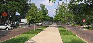
The West Orange Trail is a 22-mile (35 km) long multi-use rail trail owned by Orange County Parks and Recreation in Orange County, Florida, in the United States. The paved trail passes through downtown Oakland, Winter Garden, and Apopka with most of its length built on old railroad alignments. To the west of the West Orange Trail is the South Lake-Lake Minneola Scenic Trail in Lake County which was connected to the trail in 2007.
Tinker's Creek, in Cuyahoga, Summit and Portage counties, is the largest tributary of the Cuyahoga River, providing about a third of its flow into Lake Erie.

The 74-mile-long (119 km) Ocklawaha River flows north from central Florida until it joins the St. Johns River near Palatka. Its name is a corruption of ak-lowahe, Creek for "muddy".

Wilson Lake is a reservoir in the U.S. state of Kansas, on the border of Russell County and Lincoln County. Built and managed by the U.S. Army Corps of Engineers for flood control, it is also used for wildlife management and recreation. Several parks are located along its shoreline, including Wilson State Park.

The Withlacoochee River originates in central Florida's Green Swamp, east of Polk City. It flows west, then north, and then turns northwest and finally west again before it empties into the Gulf of Mexico near Yankeetown. The river is 141 miles (227 km) long and has a drainage basin of 1,170 square miles (3,000 km2). It is believed to have been named after the Withlacoochee River to the north.

The Wekiva River is a 16.0-mile-long (25.7 km) river in Central Florida, north of Orlando in the United States. It originates in Apopka and joins the St. Johns River, the longest river in the state, in DeBary. The Wekiva River system includes the main stem joined by three main tributaries - Rock Springs Run, Blackwater Creek, and the Little Wekiva River - and about 30 contributing groundwater springs. It is designated as a Florida State Canoe Trail, an Outstanding Florida Water, and an Aquatic Preserve by the Florida Department of Environmental Protection. The Wekiva River system is also one of the two rivers in Florida federally designated as a National Wild and Scenic River for its scenery, recreation, geology, and diverse habitats.

The Oroville–Thermalito Complex is a group of reservoirs, structures, and facilities located in and around the city of Oroville in Butte County, California. The complex serves not only as a regional water conveyance and storage system, but is the headwaters for, and therefore perhaps is the most vital part of, the California Department of Water Resources' State Water Project, the world's largest publicly built and operated water and power development and conveyance system.

Tsala Apopka Lake is a chain of lakes located within a bend in the Withlacoochee River in Citrus County in north central Florida. This area is known historically as the Cove of the Withlacoochee.
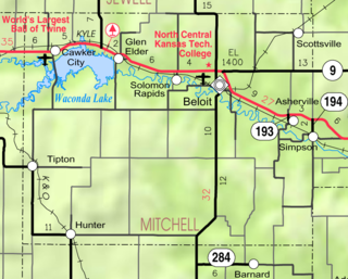
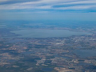
Waconda Lake, also known as Glen Elder Reservoir, is a reservoir in Mitchell County and Osborne County, Kansas, United States. Built and managed by the U.S. Bureau of Reclamation for flood control and irrigation, it is also used for recreation. Glen Elder State Park is located on its north shore.
Atwood Lake is a reservoir located in Tuscarawas and Carroll counties in east central Ohio. The lake is formed by Atwood Dam 40°31′36″N81°17′5″W across Indian Fork, a tributary of Conotton Creek. The lake is named for the community of Atwood 40°31′36″N81°17′5″W which was purchased, demolished and inundated. Evidence of an old rail station and roadbed can also be seen near Dellroy when the lake level is drawn down for winter. In addition to the Indian Fork the lake also has coves to the north up Elliott Run, Willow Run and two unnamed streams along Bark Road and Ohio State Route 542. The dam was completed in September 1936 at a cost of $1,403,900 by the Muskingum Watershed Conservancy District. The operation of the lake and dam, along with the property immediately surrounding the dam site, was transferred to the U.S. Army Corps of Engineers, Huntington District, after the approval of the Flood Control Act of 1939 by Congress. The MWCD continues to be responsible for the management of much of the reservoir areas behind the dam, serving as a partner to the U.S. Army Corps of Engineers for flood reduction. In addition to operating a number of recreation facilities, the MWCD cooperates with the Ohio Division of Wildlife for fishing and hunting management.
The Palatlakaha River is a river in Lake County, Florida. It forms the principal headwater of the Ocklawaha River, a tributary of St. Johns River. The source of the Palatlakaha River is at Lake Louisa, itself fed from the Green Swamp by two streams known as Big Creek and Little Creek.

Bugg Spring is a second magnitude spring near Okahumpka in Lake County, Florida. The spring has a 400 feet wide pool with little vegetation which goes down to 170 to 175 feet. Its outflow runs north as Bugg Spring Run into the Helena Run from Lake Denham and into Lake Harris.
The Clermont chain of lakes is a chain of lakes centered on Clermont, Florida. The chain is orientated from southeast to northwest and fed primarily by streams and groundwater flow. They make up the middle part of the Palatlakaha River watershed which forms the headwaters of the Ocklawaha River. The lakes are notable for their red to tea-colored water from tannic acid. US 27 parallels the chain to the east.

The Kirk Lake is a reservoir in the hamlet of Mahopac in the town of Carmel in Putnam County, New York. It lies due west and sharply below considerably larger Lake Mahopac. It is one of three controlled lakes in the New York City water supply system's Croton Watershed.