
Marion County is a county located in the North Central region of the U.S. state of Florida. As of the 2020 census, the population was 375,908. Its county seat is Ocala. Marion County comprises the Ocala, Florida Metropolitan Statistical Area. It includes part of Ocala National Forest, which also extends into three other counties.
Citrus County is a county located on the northwest central coast of the U.S. state of Florida. As of the 2020 census, the population was 153,843. Its county seat is Inverness, and its largest community is Homosassa Springs.

Levy County is a county located on the Gulf coast in the northwestern part of the U.S. state of Florida. As of the 2020 census, the population was 42,915. Its county seat is Bronson. It has been included in the Gainesville, Florida Metropolitan Statistical Area since 2018.
Sumter County is a county located in the central portion of the U.S. state of Florida. As of the 2020 census, the population is 129,752. It has the oldest median age of any US county and the highest percentage of residents aged 65 and older—at 55.6% in 2014–2018. Its county seat is Bushnell, and the largest city is Wildwood. Although the community of The Villages has more residents, it is a part of unincorporated Sumter County.
West Melbourne is a city in Brevard County, Florida, United States. It was created in 1959 to stop the area from being annexed into the city of Melbourne. Since 2000, the city has experienced the highest population growth percentage of any municipality in Brevard County. It is part of the Palm Bay–Melbourne–Titusville, Florida Metropolitan Statistical Area. As of the 2020 US Census, the population was 25,924, up from 18,355 at the 2010 census.

Citrus Springs is a census-designated place (CDP) in Citrus County, Florida, United States. The population was 10,246 at the 2020 census, up from 8,622 at the 2010 census. It is part of the Homosassa Springs, Florida Metropolitan Statistical Area.

Hernando is a census-designated place in Citrus County, Florida, United States. The population was 9,284 at the 2020 census, up from 9,054 at the 2010 census. At one time it was a city but it was disincorporated in the 1970s. It is part of the Homosassa Springs, Florida Metropolitan Statistical Area.

Howey-In-The-Hills is a town in Lake County, Florida, United States. The population was 1,643 at the 2020 census. It is part of the Orlando–Kissimmee–Sanford Metropolitan Statistical Area.

Umatilla is a city in Lake County, Florida, United States. The population was 3,685 at the 2020 census. Umatilla is known as the Gateway to the Ocala National Forest, located in northern Lake County.

Inglis is a town in Levy County, Florida, United States. It is on U.S. Highway 19 near the Cross Florida Greenway. As of the 2020 census, the town had a population of 1,476, up from 1,325 at the 2010 census. It is part of the Gainesville, Florida Metropolitan Statistical Area.

Yankeetown is a town in Levy County, Florida, United States. Its located in North Florida along the Gulf of Mexico. It is part of both the Big Bend Coast and the Nature Coast. In the 2020 census, the population was 588, up from 502 at the 2010 census. It is part of the Gainesville, Florida Metropolitan Statistical Area.
Belleview is a city in Marion County, Florida, United States. The population was 5,413 at the 2020 census, up from 4,492 in 2010. It is part of the Ocala Metropolitan Statistical Area. The city's name comes from the French words belle and vue, meaning "beautiful view". "City with Small Town Charm" is the city's motto.

McIntosh is a town in Marion County, Florida, United States. It is part of the Ocala, Florida Metropolitan Statistical Area. As of the 2020 census, the town population was 463, up from 452 at the 2010 census.
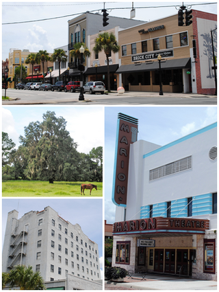
Ocala is a city in and the county seat of Marion County, Florida, United States. Located in North Central Florida, the city's population was 63,591 as of the 2020 census, up from 56,315 at the 2010 census and making it the 43rd-most populated city in Florida. Ocala is the principal city of the Ocala metropolitan area, which had a population of 375,908 in 2020.

Reddick is a town in Marion County, Florida, United States. It is part of the Ocala Metropolitan Statistical Area. As of the 2020 US census, the town population was 449, down from 506 in 2010 US census.

Callahan is a town in Nassau County, Florida, United States, adjacent to Duval County. The population was 1,526 at the 2020 census, up from 1,123 at the 2010 census. It is part of the Jacksonville, Florida Metropolitan Statistical Area. It is one location of the Northeast Florida Fair.
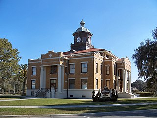
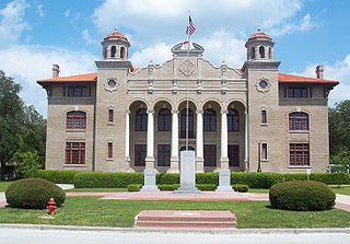
Bushnell is a city and the county seat of Sumter County, Florida, United States. The population was 3,047 at the 2020 census. It is part of The Villages metropolitan area, which consists of all of Sumter County and is included in the Orlando–Lakeland–Deltona combined statistical area.
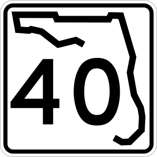
State Road 40 is a 91.8-mile-long (147.7 km) east–west highway across northern and east-central Florida, running from U.S. Highway 41 (US 41) in Rainbow Lakes Estates eastward through Ocala over the Ocklawaha River and through the heart of the Ocala National Forest to SR A1A in Ormond Beach. Names of the road include Silver Springs Boulevard in Ocala, Fort Brooks Road from Silver Springs through Astor, Butler Road in Astor, and Granada Boulevard in Ormond Beach. Former sections in Ormond Beach are named "Old Tomoka Road" and "Old Tomoka Avenue."
Rainbow Lakes Estates is an unincorporated community and census-designated place (CDP) in Marion and Levy counties, Florida, United States, established as a Municipal Services District. The Marion County part of the community is part of the Ocala, Florida Metropolitan Statistical Area, while the Levy County portion is part of the Gainesville, Florida Metropolitan Statistical Area. It was first listed as a CDP for the 2020 census, at which time it had a population of 3,438.
Rainbow Park is an unincorporated community and census-designated place (CDP) in western Marion County, Florida, United States. It is on the northwest side of Florida State Road 40, 14 miles (23 km) west of Ocala, the county seat, and 10 miles (16 km) northeast of Dunnellon.


