Brewton, Alabama

Last updated

Brewton, Alabama
Brewton Commercial Historic District Oct 2014 1.jpg
Brewton Commercial Historic District
Flag of Brewton, Alabama.png
Seal of Brewton, Alabama.png
Escambia County Alabama Incorporated and Unincorporated areas Brewton Highlighted 0109208.svg
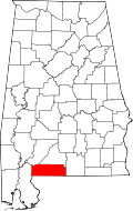
Location of Brewton in Escambia County, Alabama
Coordinates: 31°7′3″N87°4′16″W / 31.11750°N 87.07111°W / 31.11750; -87.07111
CountryUnited States
State Alabama
County Escambia
Government
  MayorYank Lovelace
Area
[1]
  Total11.53 sq mi (29.87 km2)
  Land11.30 sq mi (29.26 km2)
  Water0.24 sq mi (0.61 km2)
Elevation
82 ft (25 m)
Population
 (2020)
  Total5,276
  Density467.07/sq mi (180.33/km2)
Time zone UTC−6 (Central (CST))
  Summer (DST) UTC−5 (CDT)
ZIP Code
36426-36427
Area code 251
FIPS code 01-09208
GNIS feature ID0157900
Website http://www.cityofbrewton.org/

Brewton is a city in and the county seat of Escambia County, Alabama, United States. As of the 2020 census, the population was 5,276. Brewton is located in south central Alabama, just north of the Florida Panhandle.

Contents

Brewton was home to the Downing Industrial School, a school for girls. Brewton was ranked as one of the 100 best small towns in America in Norman Crampton's book, The 100 Best Small Towns in America (1995). [2]

History

Sign for Brewton on State Route 41 Brewton Alabama.jpg
Sign for Brewton on State Route 41

The settlement at this site was originally known as Newport; barges made runs to and from Pensacola, Florida on Murder Creek and Burnt Corn Creek, before the railroad was constructed. In May 1861, Brewton was established as a train stop by Edmund Troupe Bruton. The area's lumber began to be harvested by industrialists.

During the Civil War, rail lines were severed, and small lumber mills were damaged or destroyed. After the war, the people rebuilt the Brewton economy, began a school, and established small businesses. Into the 1870s a new European demand for lumber stimulated the founding of numerous timber and lumber operations. The Conecuh-Escambia river system became a timber artery to ports on the Gulf of Mexico.

Brewton was established as a town on February 13, 1885. The state legislature designated the town as the seat of Escambia County, Alabama.

Brewton was known in past times as "the richest little town in the South." Brewton's high per capita income was based on the profits enjoyed by a small number of "timber barons." They had come at the end of the 19th century to harvest the pine forests. With their profits, they had extraordinary homes built along Belleville and Evergreen avenues. Such families include the McMillans, Lovelace and the Millers, many of whose descendants still reside in the town.

Over time the county erected a series of courthouses. Brewton developed an education system that included public and private institutions, including T. R. Miller High School. It was named for Thomas Richard Miller, a local timber baron and town father who donated money toward the building and opening of the school. Jefferson Davis Community College was established here in 1964; it has been renamed as Coastal Alabama Community College Brewton.

Geography

Brewton is located at 31°7′4″N87°4′16″W / 31.11778°N 87.07111°W / 31.11778; -87.07111 (31.117706, -87.071164). [3]

According to the U.S. Census Bureau, the city has a total area of 11.5 square miles (30 km2), of which 11.3 square miles (29 km2) is land and 0.1 square miles (0.26 km2) (1.22%) is water.

Climate

Climate is characterized by relatively high temperatures and evenly distributed precipitation throughout the year. The Köppen Climate Classification sub-type for this climate is "Cfa" (Humid Subtropical Climate). [4] The hottest temperature ever recorded in the city was 109 °F (43 °C) on June 18, 1933, [5] and the coldest temperature ever recorded was 3 °F (−16 °C) on January 21, 1985. [5]

Climate data for Brewton, Alabama (Brewton 3 SSE), 1981–2010 normals
MonthJanFebMarAprMayJunJulAugSepOctNovDecYear
Record high °F (°C)87
(31)
96
(36)
91
(33)
95
(35)
100
(38)
109
(43)
106
(41)
104
(40)
102
(39)
98
(37)
89
(32)
84
(29)
109
(43)
Mean daily maximum °F (°C)61.6
(16.4)
65.5
(18.6)
72.5
(22.5)
78.6
(25.9)
85.1
(29.5)
89.7
(32.1)
91.6
(33.1)
91.0
(32.8)
87.1
(30.6)
79.4
(26.3)
71.4
(21.9)
63.5
(17.5)
78.1
(25.6)
Mean daily minimum °F (°C)35.7
(2.1)
38.5
(3.6)
43.8
(6.6)
49.7
(9.8)
58.5
(14.7)
66.1
(18.9)
69.3
(20.7)
69.3
(20.7)
63.6
(17.6)
51.9
(11.1)
43.0
(6.1)
37.8
(3.2)
52.3
(11.3)
Record low °F (°C)3
(−16)
11
(−12)
10
(−12)
25
(−4)
34
(1)
40
(4)
55
(13)
53
(12)
32
(0)
21
(−6)
15
(−9)
7
(−14)
3
(−16)
Average precipitation inches (mm)5.89
(150)
5.42
(138)
6.27
(159)
4.70
(119)
4.86
(123)
5.91
(150)
6.67
(169)
6.30
(160)
5.74
(146)
3.75
(95)
5.28
(134)
4.76
(121)
65.54
(1,665)
Average precipitation days (≥ 0.01 in)8.57.67.05.87.410.011.711.27.65.46.57.496.1
Source: NOAA (extremes 1926–present) [5]

Demographics

Historical population
CensusPop.Note
1870 1,312
1880 1,66026.5%
1890 1,115−32.8%
1900 1,38223.9%
1910 2,18558.1%
1920 2,68222.7%
1930 2,8185.1%
1940 3,32317.9%
1950 5,14654.9%
1960 6,30922.6%
1970 6,7476.9%
1980 6,680−1.0%
1990 5,885−11.9%
2000 5,498−6.6%
2010 5,408−1.6%
2020 5,276−2.4%
U.S. Decennial Census [6]
2013 Estimate [7]

Brewton first appeared on the 1870 U.S. Census as a Beat (Precinct) 5 of Escambia County. [8] It appeared as Beat (Precinct) 3 in 1880. [9] The population listed here for 1870-80 was the entire precinct, also including the area outside the town. Beginning with the 1890 [10] U.S. Census, it appeared separately as an incorporated town.

2020 census

Brewton racial composition [11]
RaceTotalPercent
White (non-Hispanic)2,79652.99%
Black or African American (non-Hispanic)2,14640.67%
Native American 330.63%
Asian 230.44%
Pacific Islander 70.13%
Other/Mixed 1663.15%
Hispanic or Latino 1051.99%

As of the 2020 U.S. census, there were 5,276 people, 2,050 households, and 1,249 families residing in the city.

2010 census

As of the 2010 census [12] there were 5,408 people, 2,171 households, and 1,412 families residing in the city. The population density was 474.9 inhabitants per square mile (183.4/km2). There were 2,522 housing units at an average density of 221.2 per square mile (85.4/km2). The racial makeup of the city was 54.1% White or Caucasian, 42.6% Black or African American, 0.7% Native American, 0.4% Asian, 1.1% from other races, and 1.0% from two or more races. 2.2% of the population were Hispanic or Latino of any race.

There were 2,171 households, out of which 25.6% had children under the age of 18 living with them, 41.1% were married couples living together, 19.6% had a female householder with no husband present, and 35.0% were non-families. 32.0% of all households were made up of individuals, and 16.3% had someone living alone who was 65 years of age or older. The average household size was 2.36 and the average family size was 2.97.

In the city, the population was spread out, with 22.7% under the age of 18, 7.8% from 18 to 24, 22.4% from 25 to 44, 27.9% from 45 to 64, and 19.2% who were 65 years of age or older. The median age was 42.4 years. For every 100 females, there were 86.2 males. For every 100 females age 18 and over, there were 96.8 males.

The median income for a household in the city was $34,390, and the median income for a family was $49,554. Males had a median income of $35,233 versus $28,879 for females. The per capita income for the city was $20,467. About 19.6% of families and 22.3% of the population were below the poverty line, including 41.3% of those under age 18 and 7.9% of those age 65 or over.

Former Town of Alco (c1885/1888-1897)

Historical population
CensusPop.Note
1890 249
U.S. Decennial Census [6]

Within Brewton is the former incorporated town of Alco. [13] It existed from the mid-to-late 1880s (exact incorporation date uncertain) until it was dissolved as a town in 1897. [14] The name was derived from the Alabama Lumber Company. It was located just southwest of Brewton & the junction of Burnt Corn & Murder Creeks 31°05′50.6″N87°05′07.9″W / 31.097389°N 87.085528°W / 31.097389; -87.085528 (Alco United Methodist Church, Alabama) . [15] The name of the town still lives on today on the names of the churches (Alco Baptist Church & Alco United Methodist Church) and Alco Road. Pilgrim's Rest Cemetery, one of the oldest in Escambia County, is located across from the United Methodist Church and mentions Alco on its historic marker. [16] Alco was annexed into Brewton on June 31, 1945.

Historic Demographics

Census
Year
PopulationState
Place
Rank
County
Place
Rank
1890 [lower-alpha 1] [10] 249 (-) [lower-alpha 2] [lower-alpha 3] 139th (-)3rd (-)

Government

The city government consists of a part-time mayor elected at-large and a five-member part-time city council elected from districts. Brewton utilizes a city school system.

Culture and special events

Streetlight banner proclaiming Brewton as "Home of the Alabama Blueberry Festival" BrewtonIMG 1459.JPG
Streetlight banner proclaiming Brewton as "Home of the Alabama Blueberry Festival"

The annual Alabama Blueberry Festival is held at Jennings Park and downtown Brewton. Prior to 2006 it was held on the campus of Jefferson Davis Community College.

The Thomas E. McMillan Museum is housed on the campus of the Jefferson Davis Community College. [17] It was founded in 1979 to chronicle life in Escambia County, Alabama. The museum includes items from 10,000-year-old fossils, to a fireside popcorn popper and a display of cameras.

Notable people

Historic sites

Second Saint Siloam Missionary Baptist Church, 2014 Second Saint Siloam Missonary Baptist Church Oct 2014 2.jpg
Second Saint Siloam Missionary Baptist Church, 2014

Brewton has one site listed on the National Register of Historic Places, the Brewton Historic Commercial District. [20]

The historic Second Saint Siloam Missionary Baptist Church was established on November 5, 1909, when a group of worshipers gathered at the Congregational Church on the corner of St. Joseph and Evergreen avenues in Brewton to organize a new church. The Second St. Siloam Missionary Baptist Church was dedicated on June 10, 1910, on the corner of East and North streets. On April 1, 2010, the church was added to the Alabama Register of Historic Places. [21]

Related Research Articles

<span class="mw-page-title-main">Santa Rosa County, Florida</span> County in Florida, United States

Santa Rosa County is a county located in the northwestern portion of the U.S. state of Florida. As of 2020, the population is 188,000. The county seat is Milton, which lies in the geographic center of the county. Other major communities within Santa Rosa County are Navarre, Pace, and Gulf Breeze. Navarre is the most populated community with a population of approximately 45,000 residents. Santa Rosa County is included in the Pensacola Metropolitan Statistical Area, which also includes Escambia County.

<span class="mw-page-title-main">Escambia County, Alabama</span> County in Alabama, United States

Escambia County is a county located in the south central portion of the U.S. state of Alabama. As of the 2020 census, the population was 36,757. Its county seat is Brewton.

<span class="mw-page-title-main">Lamar County, Alabama</span> County in Alabama, United States

Lamar County is a county in the U.S. state of Alabama. As of the 2020 census, the population was 13,972. Its county seat is Vernon and it is a dry county. It is named in honor of Lucius Quintus Cincinnatus Lamar, a former Confederate officer and former member of both houses of the United States Congress from Mississippi.

<span class="mw-page-title-main">Wilcox County, Alabama</span> County in Alabama, United States

Wilcox County is a county of the U.S. state of Alabama. As of the 2020 census, the population was 10,600. Its county seat is Camden.

<span class="mw-page-title-main">Loxley, Alabama</span> City in Alabama, United States

Loxley is a city in Baldwin County, Alabama, United States. As of the 2010 census, the population of the town was 1,632. It is part of the Daphne-Fairhope-Foley metropolitan area. Loxley is becoming a popular location for the expansion of the suburbs from Daphne and Spanish Fort, Alabama, because it is served by an Interstate 10 exit and is almost directly between the cities of Mobile, Alabama, and Pensacola, Florida.

<span class="mw-page-title-main">Brent, Alabama</span> City in Alabama, United States

Brent is a city in Bibb County, Alabama, United States. At the 2020 census, the population was 2,972.

<span class="mw-page-title-main">Andalusia, Alabama</span> City in and county seat of Covington County, Alabama

Andalusia is a city in and the county seat of Covington County, Alabama, United States. At the 2020 census, the population was 8,805.

<span class="mw-page-title-main">Atmore, Alabama</span> City in Alabama, United States

Atmore is a city in Escambia County, Alabama, United States. The population was 8,391 at the 2020 census. It was incorporated on May 9, 1907.

<span class="mw-page-title-main">East Brewton, Alabama</span> City in Alabama, United States

East Brewton is a city in Escambia County, Alabama, United States. It was incorporated in October 1918. At the 2020 census, the population was 2,293. The community grew around Fort Crawford, a fort built to protect early settlers of the area.

<span class="mw-page-title-main">Flomaton, Alabama</span> Town in Alabama, United States

Flomaton is a town in Escambia County, Alabama, United States. At the 2010 census the town's population was 1,440. It is located next to the Alabama / Florida state line.

<span class="mw-page-title-main">Pollard, Alabama</span> Town in Alabama, United States

Pollard is a town in Escambia County, Alabama, United States. It was the first established county seat of Escambia County, from its creation in 1868 until 1883, when it lost that distinction to Brewton. At the 2020 census, the population was 128.

<span class="mw-page-title-main">Riverview, Alabama</span> Town in Alabama, United States

Riverview is a town in Escambia County, Alabama, United States. At the 2010 census the population was 184, up from 99 at the 2000 census.

<span class="mw-page-title-main">Boaz, Alabama</span> City in Alabama, United States

Boaz is a city in Marshall and Etowah counties in the U.S. state of Alabama. The Marshall County portion of the city is part of the Albertville Micropolitan Statistical Area. As of the 2020 census, the city's population was 10,107. Boaz was known for its outlet shops.

<span class="mw-page-title-main">West Jefferson, Alabama</span> Town in Alabama, United States

West Jefferson is a town in Jefferson County, Alabama, United States. It incorporated in October 1964. At the 2010 census the population was 338, down from 344 in 2000.

<span class="mw-page-title-main">Phenix City, Alabama</span> City in Alabama, United States

Phenix City is a city in Lee and Russell counties in the U.S. state of Alabama, and the county seat of Russell County. As of the 2020 Census, the population of the city was 38,817.

<span class="mw-page-title-main">Dayton, Alabama</span> Town in Alabama, United States

Dayton is a town in Marengo County, Alabama, United States. The population was 28 at the 2020 census.

<span class="mw-page-title-main">Century, Florida</span> Town in Florida, United States

Century is a town in Escambia County, Florida, United States. Per the 2020 census, the population was 1,713. It is part of the Pensacola–Ferry Pass–Brent Metropolitan Statistical Area.

<span class="mw-page-title-main">Jay, Florida</span> Town in the state of Florida, United States

Jay is a town in Santa Rosa County, Florida, United States. The Town of Jay is part of the Pensacola–Ferry Pass–Brent Metropolitan Statistical Area, and located on the Florida Panhandle in North Florida. The population was 524 at the 2020 census.

<span class="mw-page-title-main">Loretto, Tennessee</span> City in Tennessee, United States

Loretto is a city in Lawrence County, Tennessee, United States. The population was 1,714 at the 2010 census, and 1,739 at the 2020 census.

<span class="mw-page-title-main">Valley Grande, Alabama</span> City in Alabama, United States

Valley Grande is a city in Dallas County, Alabama, United States, just north of Selma. Incorporated in early 2003, Valley Grande has a mayor-council form of government. The city's population was 4,020 at the time of the 2010 census.

References

Notes

  1. 1st year Alco reported on census
  2. (-)Indicates no immediate prior population figure or rank
  3. Racial demographics not reported for places of less than 2,500 on 1890 census.

References

  1. "2020 U.S. Gazetteer Files". United States Census Bureau. Retrieved October 29, 2021.
  2. "Brewton Chamber of Commerce". brewtonchamber.com. Retrieved August 6, 2018.
  3. "US Gazetteer files: 2010, 2000, and 1990". United States Census Bureau. February 12, 2011. Retrieved April 23, 2011.
  4. "Brewton, Alabama Köppen Climate Classification (Weatherbase)". Weatherbase.com. Retrieved January 16, 2018.
  5. 1 2 3 "NowData — NOAA Online Weather Data". National Oceanic and Atmospheric Administration . Retrieved November 25, 2013.
  6. 1 2 "U.S. Decennial Census". Census.gov. Retrieved June 6, 2013.
  7. "Annual Estimates of the Resident Population: April 1, 2010 to July 1, 2013". Archived from the original on May 22, 2014. Retrieved June 3, 2014.
  8. "Population of Civil Divisions less than counties" (PDF). United States Census Bureau. 1870. pp. 77–82.
  9. "Population of Civil Divisions less than counties, in the aggregate, at the Censuses of 1880 and 1870" (PDF). United States Census Bureau. 1880.
  10. 1 2 "Statistics of Population - Minor Civil Divisions 1880 and 1890 - Alabama" (PDF). United States Census Bureau. 1890. pp. 52–59.
  11. "Explore Census Data". data.census.gov. Retrieved December 14, 2021.
  12. "U.S. Census website". United States Census Bureau . Retrieved July 22, 2015.
  13. Escambia. "Current of Historic Place" (PDF). pp. 141–144. Archived (PDF) from the original on April 25, 2023.
  14. Pilgrims Rest Cemetery entry
  15. "GNIS Detail - Alco United Methodist Church".
  16. "Pilgrims' Rest Cemetery - Brewton, AL - Alabama Historical Markers on". Waymarking.com. Retrieved May 3, 2022.
  17. "Museum". Museum.jdcc.edu. Archived from the original on December 29, 2017. Retrieved January 16, 2018.
  18. "Harvey, William R. 1941–". Encyclopedia.com . Retrieved January 4, 2019.
  19. "Edward O. Wilson".
  20. "National Register Information System". National Register of Historic Places . National Park Service. July 9, 2010.
  21. "The Alabama Register of Landmarks & Heritage" (PDF). Alabama Historical Commission. December 13, 2016. p. 48. Archived from the original (PDF) on March 21, 2017.