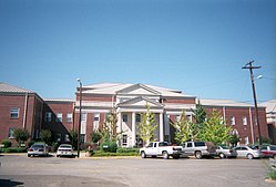
Grove Hill, Alabama | |
---|---|
Town | |
Coordinates: 31°42′22″N87°46′27″W / 31.70611°N 87.77417°W | |
Country | United States |
State | Alabama |
County | Clarke |
Government | |
• Type | Mayor/Council |
• Mayor | Ross Wood |
Area | |
• Total | 7.60 sq mi (19.68 km2) |
• Land | 7.59 sq mi (19.66 km2) |
• Water | 0.01 sq mi (0.02 km2) |
Elevation | 505 ft (154 m) |
Population (2020) | |
• Total | 1,818 |
• Density | 239.53/sq mi (92.48/km2) |
Time zone | UTC-6 (Central (CST)) |
• Summer (DST) | UTC-5 (CDT) |
ZIP code | 36451 |
Area code | 251 |
FIPS code | 01-32080 |
GNIS feature ID | 0155087 |
Website | https://townofgrovehillalabama.com/ |
Grove Hill is a town in Clarke County, Alabama, United States. At the 2020 census, the population was 1,818. It is the county seat of Clarke County and home of the Clarke County Museum.
The area that is now Grove Hill was originally inhabited by Creek and Choctaw Indians. During the Creek War, settlers in the community sought protection in Fort White. [2] The county seat of Clarke County was established at what later became Grove Hill in 1832 as the spot was most central to the rest of the county. Known variously as Smithville, then Macon, the name Grove Hill was selected around 1850 for the large grove of oak trees on the plateau. The town was officially incorporated and chartered in 1929. [3] In 1853, a yellow fever epidemic struck the town, killing many residents, almost wiping out the town. [4]
The Grove Hill area has numerous sites on the National Register of Historic Places including the Alston-Cobb House, Bush House, John A. Coate House, Cobb House, Dickinson House, Fort Sinquefield, and the Grove Hill Courthouse Square Historic District. [5]
According to the U.S. Census Bureau, the town has a total area of 5.0 square miles (13 km2), all land. [6]
According to the Köppen climate classification, Grove Hill has a humid subtropical climate (abbreviated Cfa).
Climate data for Grove Hill, 1991–2020 simulated normals (505 ft elevation) | |||||||||||||
---|---|---|---|---|---|---|---|---|---|---|---|---|---|
Month | Jan | Feb | Mar | Apr | May | Jun | Jul | Aug | Sep | Oct | Nov | Dec | Year |
Mean daily maximum °F (°C) | 57.6 (14.2) | 62.2 (16.8) | 69.4 (20.8) | 76.3 (24.6) | 83.5 (28.6) | 88.7 (31.5) | 90.9 (32.7) | 90.3 (32.4) | 86.4 (30.2) | 77.7 (25.4) | 67.3 (19.6) | 59.7 (15.4) | 75.8 (24.3) |
Daily mean °F (°C) | 46.9 (8.3) | 51.1 (10.6) | 57.7 (14.3) | 64.6 (18.1) | 72.7 (22.6) | 79.0 (26.1) | 81.1 (27.3) | 80.4 (26.9) | 76.1 (24.5) | 66.7 (19.3) | 56.1 (13.4) | 49.1 (9.5) | 65.1 (18.4) |
Mean daily minimum °F (°C) | 36.5 (2.5) | 40.1 (4.5) | 46.2 (7.9) | 53.1 (11.7) | 61.7 (16.5) | 69.1 (20.6) | 71.4 (21.9) | 70.5 (21.4) | 65.8 (18.8) | 55.9 (13.3) | 44.8 (7.1) | 38.7 (3.7) | 54.5 (12.5) |
Average precipitation inches (mm) | 5.60 (142.17) | 5.14 (130.58) | 5.56 (141.15) | 4.35 (110.61) | 4.10 (104.15) | 5.73 (145.59) | 6.45 (163.93) | 5.14 (130.53) | 4.45 (113.06) | 3.59 (91.24) | 4.39 (111.55) | 5.82 (147.75) | 60.32 (1,532.31) |
Average dew point °F (°C) | 38.8 (3.8) | 42.4 (5.8) | 47.5 (8.6) | 54.1 (12.3) | 62.1 (16.7) | 69.1 (20.6) | 71.8 (22.1) | 71.1 (21.7) | 66.9 (19.4) | 57.6 (14.2) | 48.0 (8.9) | 41.9 (5.5) | 55.9 (13.3) |
Source: Prism Climate Group [7] |
Census | Pop. | Note | %± |
---|---|---|---|
1870 | 200 | — | |
1880 | 176 | −12.0% | |
1890 | 225 | 27.8% | |
1930 | 491 | — | |
1940 | 730 | 48.7% | |
1950 | 1,443 | 97.7% | |
1960 | 1,834 | 27.1% | |
1970 | 1,825 | −0.5% | |
1980 | 1,912 | 4.8% | |
1990 | 1,551 | −18.9% | |
2000 | 1,438 | −7.3% | |
2010 | 1,570 | 9.2% | |
2020 | 1,818 | 15.8% | |
U.S. Decennial Census [8] 2013 Estimate [9] |
Race / Ethnicity (NH = Non-Hispanic) | Pop 2000 [10] | Pop 2010 [11] | Pop 2020 [12] | % 2000 | % 2010 | % 2020 |
---|---|---|---|---|---|---|
White alone (NH) | 889 | 873 | 938 | 61.82% | 55.61% | 51.60% |
Black or African American alone (NH) | 536 | 646 | 790 | 37.27% | 41.15% | 43.45% |
Native American or Alaska Native alone (NH) | 3 | 3 | 12 | 0.21% | 0.19% | 0.66% |
Asian alone (NH) | 0 | 5 | 13 | 0.00% | 0.32% | 0.72% |
Pacific Islander alone (NH) | 0 | 0 | 0 | 0.00% | 0.00% | 0.00% |
Other race alone (NH) | 0 | 2 | 7 | 0.00% | 0.13% | 0.39% |
Mixed race or Multiracial (NH) | 5 | 10 | 36 | 0.35% | 0.64% | 1.98% |
Hispanic or Latino (any race) | 5 | 31 | 22 | 0.35% | 1.97% | 1.21% |
Total | 1,438 | 1,570 | 1,818 | 100.00% | 100.00% | 100.00% |
As of the 2020 United States Census, there were 1,818 people, 669 households, and 467 families residing in the town.
As of the census [13] of 2010, there were 1,570 people, 615 households, and 402 families residing in the town. The racial makeup of the town was 56.6% White, 41.3% Black or African American, 0.3% Native American, 0.5% from other races, and 1.0% from two or more races. 2.0% of the population were Hispanic or Latino of any race.
There were 582 households, out of which 30.6% had children under the age of 18 living with them, 41.5% were married couples living together, 21.0% had a female householder with no husband present, and 34.6% were non-families. 31.9% of all households were made up of individuals, and 14.8% had someone living alone who was 65 years of age or older. The average household size was 2.36 and the average family size was 2.99.
In the town, the population was spread out, with 23.9% under the age of 18, 8.0% from 18 to 24, 26.0% from 25 to 44, 25.8% from 45 to 64, and 16.2% who were 65 years of age or older. The median age was 38.5 years. For every 100 females, there were 98.2 males. For every 100 females age 18 and over, there were 107.3 males.
Public Education is provided by the Clarke County School System. Located in Grove Hill are Clarke County High School (grades 9 through 12), Wilson Hall Middle School (grades 5 through 8), and Grove Hill Elementary School (grades K though 4).
There is one private school in Grove Hill. Clarke Preparatory School provides education for grades K through 12.
WBMH 106.1 FM (Classic Country)
Bibb County is a county in the central portion of the U.S. state of Alabama. The county is included in the ARC's definition of Appalachia. As of the 24th decennial 2020 census, its population was 22,293. The county seat is Centreville. The county is named in honor of William W. Bibb (1781–1820), the Governor of Alabama Territory (1817–1819) and the first Governor of Alabama. He is also the namesake for Bibb County, Georgia, where he began his political career. It is a "prohibition" or dry county; however, a few towns have become "wet" by allowing the sale of alcoholic beverages: Woodstock, West Blocton, Centreville, and Brent. The Bibb County Courthouse is located in the county seat of Centreville.
Butler County is a county located in the south central portion of the U.S. state of Alabama. As of the 2020 census, the population was 19,051. Its county seat is Greenville. Its name is in honor of Captain William Butler, who was born in Virginia and fought in the Creek War, and who was killed in May 1818.
Choctaw County is a county located in the southwestern portion of the U.S. state of Alabama. As of the 2020 census, the population was 12,665. The county seat is Butler. The county was established on December 29, 1847, and named for the Choctaw tribe of Native Americans.
Clarke County is a county located in the southwestern part of the U.S. state of Alabama. As of the 2020 census, the population was 23,087. The county seat is Grove Hill. The county's largest city is Jackson. The county was created by the legislature of the Mississippi Territory in 1812. It is named in honor of General John Clarke of Georgia, who was later elected governor of that state.
Cullman County is a county located in the north central portion of the U.S. state of Alabama. As of the 2020 census, the population was 87,866. Its county seat and largest city is Cullman. Its name is in honor of Colonel John G. Cullmann.
Franklin County is a county located in the U.S. state of Alabama. As of the 2020 census, the population was 32,113. Its county seat is Russellville. Its name is in honor of Benjamin Franklin, famous statesman, scientist, and printer. It is a dry county, although the city of Russellville is wet.
Hale County is a county located in the west central portion of the U.S. state of Alabama. As of the 2020 census, the population was 14,785. Its county seat is Greensboro. It is named in honor of Confederate officer Stephen Fowler Hale.
Marengo County is a county located in the west central portion of the U.S. state of Alabama. As of the 2020 census, the population was 19,323. The largest city is Demopolis, and the county seat is Linden. It is named in honor of the Battle of Marengo near Turin, Italy, where French leader Napoleon Bonaparte defeated the Austrians on June 14, 1800.
Marshall County is a county of the state of Alabama, United States. As of the 2020 census the population was 97,612. Its county seat is Guntersville. A second courthouse is in Albertville. Its name is in honor of John Marshall, famous Chief Justice of the United States. Marshall County is a dry county, with the exception of the five cities of Albertville, Arab, Grant, Guntersville, and Boaz. Marshall County comprises the Albertville, AL Micropolitan Statistical Area, which is also included in the Huntsville-Decatur-Albertville, AL Combined Statistical Area.
Perry County is a county located in the Black Belt region in the central part of the U.S. state of Alabama. As of the 2020 census, the population was 8,511. Its county seat is Marion. The county was established in 1819 and is named in honor of Commodore Oliver Hazard Perry of Rhode Island and the United States Navy. As of 2020, Perry County was the only county in Alabama, and one of 40 in the United States, not to have access to any wired broadband connections.
Pickens County is a county located on the west central border of the U.S. state of Alabama. As of the 2020 census, the population was 19,123. Its county seat is Carrollton, located in the center of the county. It is a prohibition, or dry county, although the communities of Carrollton and Aliceville voted to become wet in 2011 and 2012, respectively.
Sumter County is a county located in the west central portion of Alabama. At the 2020 census, the population was 12,345. Its county seat is Livingston. Its name is in honor of General Thomas Sumter of South Carolina. The University of West Alabama is in Livingston.
Talladega County is one of the sixty-seven counties located in the east central portion of the U.S. state of Alabama. As of the 2020 census, the population was 82,149. Its county seat is Talladega.
Tallapoosa County is a county located in the east-central portion of the U.S. state of Alabama. As of the 2020 census, the population was 41,311. Its county seat is Dadeville. Its largest city is Alexander City.
Walker County is a county located in the central portion of the U.S. state of Alabama. As of the 2020 census, the population was 65,342. Its county seat is Jasper. Its name is in honor of John Williams Walker, the first U.S. senator elected from Alabama.
Wilcox County is a county of the U.S. state of Alabama. As of the 2020 census, the population was 10,600. Its county seat is Camden.
Pleasant Grove is a city in western Jefferson County, Alabama, United States. It is part of the Birmingham metropolitan area. The population was 9,544 at the 2020 census.
Dayton is a town in Marengo County, Alabama, United States. The population was 28 at the 2020 census.
Linden is a city in and the county seat of Marengo County, Alabama, United States. The population was 1,930 at the 2020 census, down from 2,123 at the 2010 census.
Pine Apple is a town in Wilcox County, Alabama, United States. It incorporated in 1872. Per the 2020 census, the population was 143. It has two places on the National Register of Historic Places, the Hawthorne House and the Pine Apple Historic District.
31°42′22″N87°46′27″W / 31.706137°N 87.774274°W