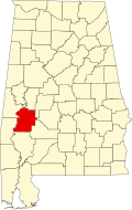
Linden, Alabama | |
---|---|
Coordinates: 32°18′4″N87°47′34″W / 32.30111°N 87.79278°W | |
Country | United States |
State | Alabama |
County | Marengo |
Government | |
• Type | Mayor/Council |
• Mayor | Gwendolyn Rogers |
Area | |
• Total | 3.61 sq mi (9.36 km2) |
• Land | 3.58 sq mi (9.27 km2) |
• Water | 0.03 sq mi (0.09 km2) |
Elevation | 161 ft (49 m) |
Population | |
• Total | 1,930 |
• Density | 539.3/sq mi (208.24/km2) |
Time zone | UTC-6 (Central (CST)) |
• Summer (DST) | UTC-5 (CDT) |
ZIP code | 36748 |
Area code | 334 |
FIPS code | 01-43240 |
GNIS feature ID | 0152070 |
Website | www |
Linden is a city in and the county seat of Marengo County, Alabama, United States. [3] The population was 1,930 at the 2020 census, [2] down from 2,123 at the 2010 census.
Settled prior to 1818, the community was first known as "Screamersville", since the cry of wild animals could still be heard during the night. It became the county seat in 1819 and was then known as the "Town of Marengo". This was changed to "Hohenlinden" in 1823, to honor the county's earliest European settlers, French Bonapartist refugees to the Vine and Olive Colony. [4] The name commemorated the battle in 1800 at Hohenlinden, Bavaria, where the French defeated the armies of both Austria and Bavaria. The spelling was later shortened to just "Linden." [5]
Linden is located in central Marengo County at 32°18′4″N87°47′34″W / 32.30111°N 87.79278°W (32.301154, −87.792650). [6] It is 16 miles (26 km) south of Demopolis, the largest city in Marengo County, 11 miles (18 km) west of Thomaston, and 28 miles (45 km) north of Thomasville.
According to the U.S. Census Bureau, the city has a total area of 3.6 square miles (9.3 km2), of which 0.03 square miles (0.08 km2), or 0.94%, are water. [1] The city drains north to Chickasaw Bogue, a west-flowing tributary of the Tombigbee River, and south to Sycamore Creek, a tributary of Chickasaw Bogue.
Census | Pop. | Note | %± |
---|---|---|---|
1860 | 171 | — | |
1870 | 300 | 75.4% | |
1910 | 600 | — | |
1920 | 700 | 16.7% | |
1930 | 982 | 40.3% | |
1940 | 1,203 | 22.5% | |
1950 | 1,363 | 13.3% | |
1960 | 2,516 | 84.6% | |
1970 | 2,697 | 7.2% | |
1980 | 2,773 | 2.8% | |
1990 | 2,548 | −8.1% | |
2000 | 2,424 | −4.9% | |
2010 | 2,123 | −12.4% | |
2020 | 1,930 | −9.1% | |
U.S. Decennial Census [7] 2013 Estimate [8] |
At the 2000 census, there were 2,424 people, 938 households, and 662 families living in the city. The population density was 675.6 inhabitants per square mile (260.9/km2). There were 1,084 housing units at an average density of 302.1 per square mile (116.6/km2). The racial makeup of the city was 52.43% White, 46.20% Black or African American, 0.17% Native American, 0.33% Asian, and 0.87% from two or more races. 1.07% of the population were Hispanic or Latino of any race. [9]
Of the 938 households 33.0% had children under the age of 18 living with them, 45.1% were married couples living together, 22.1% had a female householder with no husband present, and 29.4% were non-families. 27.8% of households were one person and 14.4% were one person aged 65 or older. The average household size was 2.48 and the average family size was 2.98. [9]
The age distribution was 27.7% under the age of 18, 8.0% from 18 to 24, 23.8% from 25 to 44, 20.9% from 45 to 64, and 19.5% 65 or older. The median age was 38 years. For every 100 females, there were 81.4 males. For every 100 females age 18 and over, there were 74.3 males. [9]
The median household income was $22,303 and the median family income was $30,733. Males had a median income of $38,964 versus $17,857 for females. The per capita income for the city was $16,536. About 23.8% of families and 29.6% of the population were below the poverty line, including 46.8% of those under age 18 and 19.0% of those age 65 or over. [9]
At the 2010 census, there were 2,123 people, 877 households, and 555 families living in the city. The population density was 589.7 inhabitants per square mile (227.7/km2). There were 1,013 housing units at an average density of 281.4 per square mile (108.6/km2). The racial makeup of the city was 51.1% White, 46.7% Black or African American, 0.1% Native American, 0.2% Asian, and 0.9% from two or more races. 2.0% of the population were Hispanic or Latino of any race. [10]
Of the 877 households 23.4% had children under the age of 18 living with them, 37.7% were married couples living together, 21.1% had a female householder with no husband present, and 36.7% were non-families. 34.3% of households were one person and 14.7% were one person aged 65 or older. The average household size was 2.25 and the average family size was 2.88.
The age distribution was 20.8% under the age of 18, 10.1% from 18 to 24, 21.2% from 25 to 44, 25.1% from 45 to 64, and 22.8% 65 or older. The median age was 42.6 years. For every 100 females, there were 85.1 males. For every 100 females age 18 and over, there were 92.0 males.
The median household income was $20,145 and the median family income was $35,714. Males had a median income of $30,833 versus $25,000 for females. The per capita income for the city was $14,701. About 31.1% of families and 31.8% of the population were below the poverty line, including 41.1% of those under age 18 and 8.7% of those age 65 or over.
Race | Num. | Perc. |
---|---|---|
White | 833 | 43.16% |
Black or African American | 1,034 | 53.58% |
Asian | 1 | 0.05% |
Other/Mixed | 45 | 2.33% |
Hispanic or Latino | 17 | 0.88% |
As of the 2020 United States Census, there were 1,930 people, 672 households, and 349 families residing in the city.
Linden is accessed by way of one U.S. Highway: US 43 which runs north-south through the city as Main Street connecting the city to Demopolis to the north and Thomasville to the south. SR 28 runs east-west through the city as Coats Avenue connecting the city to US 80 to the northwest and the towns of Thomaston and Camden to the southeast. SR 69 runs north-south through the city cosigned with US 43 before leaving US 43 at the far south end of town heading southwest towards Myrtlewood and connecting to Butler by way of SR 10.
In her 2021 State of the State address, Governor Kay Ivey confirmed that her administration would be moving forward with a long proposed plan to expand US 43 to four lanes from "Thomasville to Tuscaloosa." Upon completion, the expansion to US 43 will most likely pass around Linden by way of a bypass. [12]
The Linden Leader , a weekly newspaper, is based in Linden. [13]
The city runs its own citywide school system, Linden City Schools. It also had one private school, Marengo Academy, founded in 1969; one of many segregation academies as they are known, which cropped up in the South after segregation was made illegal. [14] [15] [16] [17] Marengo Academy closed in 2019.
Chambers County is a county located in the east central portion of the U.S. state of Alabama. As of the 2020 census the population was 34,772. Its county seat is LaFayette. Its largest city is Valley. Its name is in honor of Henry H. Chambers, who served as a United States Senator from Alabama.
Clarke County is a county located in the southwestern part of the U.S. state of Alabama. As of the 2020 census, the population was 23,087. The county seat is Grove Hill. The county's largest city is Jackson. The county was created by the legislature of the Mississippi Territory in 1812. It is named in honor of General John Clarke of Georgia, who was later elected governor of that state.
Etowah County is a county located in the northeastern part of the U.S. state of Alabama. As of the 2020 census the population was 103,436. Its county seat is Gadsden. Its name is from a Cherokee word meaning "edible tree". In total area, it is the smallest county in Alabama, but one of the most densely populated. Etowah County comprises the Gadsden Metropolitan Statistical Area.
Marengo County is a county located in the west central portion of the U.S. state of Alabama. As of the 2020 census, the population was 19,323. The largest city is Demopolis, and the county seat is Linden. It is named in honor of the Battle of Marengo near Turin, Italy, where French leader Napoleon Bonaparte defeated the Austrians on June 14, 1800.
Glencoe is a city in Calhoun and Etowah counties in the U.S. state of Alabama. It is part of the Gadsden Metropolitan Statistical Area. The city incorporated in 1939. The population was 5,160 at the 2010 census.
Hartford is a city in Geneva County, Alabama, United States. It incorporated in 1896. It is part of the Dothan, Alabama Metropolitan Statistical Area. At the 2020 census, the population was 2,651, an increase over the figure of 2,624 tabulated in 2010.
Dayton is a town in Marengo County, Alabama, United States. The population was 28 at the 2020 census.
Demopolis is the largest city in Marengo County, in west-central Alabama. The population was 7,162 at the 2020 census.
Faunsdale is a town in Marengo County, Alabama, United States. At the 2020 census the population was 90, down from 98 in 2010. Faunsdale is home to a community of Holdeman Mennonites, the only such community outside of Greensboro, Alabama. The town has the only Holdeman Mennonite Church in the area, Cedarcrest Mennonite Church.
Myrtlewood is a town in Marengo County, Alabama, United States. At the 2020 census the population was 70, down from 130 in 2010.
Providence is a town in Marengo County, Alabama, United States. As of the 2020 United States census, the population was 167, down from 223 at the 2010 census. It incorporated sometime in the 1970s.
Thomaston is a town in Marengo County, Alabama, United States. At the 2020 census the population was 326, down from 417 at the 2010 census.
Hamilton is a city in and the county seat of Marion County, Alabama, United States. It incorporated in 1896 and since 1980 has been the county's largest city, surpassing Winfield. It was previously the largest town in 1910. At the 2020 census, the population was 7,042.
Hartselle is the second largest city in Morgan County, Alabama, United States, 13 miles (21 km) south of Decatur. It is part of the Decatur Metropolitan Area and the Huntsville-Decatur Combined Statistical Area.
Marengo is a city in McHenry County, Illinois, United States on the Kishwaukee River. It lies approximately 60 miles west northwest of Chicago and approximately 30 miles east of Rockford. Per the 2020 census, the population was 7,568.
Linden is a town in Madison Township, Montgomery County, in the U.S. state of Indiana. The population was 711 at the 2020 census.
Marengo is a town in and the county seat of Iowa County, Iowa, United States. It has served as the county seat since August 1845, even though it was not incorporated until July 1859. The population was 2,435 in the 2020 census, a decline from 2,535 in 2000.
Marengo Township is a civil township of Calhoun County in the U.S. state of Michigan. It is part of the Battle Creek, Michigan Metropolitan Statistical Area. As of the 2020 census, the township population was 2,205.
Marengo is a village in Morrow County, Ohio, United States. The population was 283 at the 2020 census. Marengo is south of Mount Gilead, the county seat.
Linden is a city in and the county seat of Cass County, Texas, United States. At the 2020 United States census, its population was 1,825. Linden is named after the city of Linden in Perry County, Tennessee.