Nanafalia, Alabama | |
|---|---|
 Mathers House, the oldest house remaining in Nanafalia | |
 | |
| Coordinates: 32°06′50″N87°59′52″W / 32.11389°N 87.99778°W [1] | |
| Country | United States |
| State | Alabama |
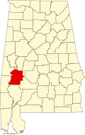
| County | Marengo |
| Area | |
• Total | 2.17 sq mi (5.6 km2) |
| • Land | 2.17 sq mi (5.6 km2) |
| • Water | 0.00 sq mi (0 km2) |
| Elevation | 217 ft (66 m) |
| Population | |
• Total | 75 |
| • Density | 34.56/sq mi (13.34/km2) |
| Time zone | UTC-6 (Central (CST)) |
| • Summer (DST) | UTC-5 (CDT) |
| ZIP code | 36764 |
| Area code | 334 |
| FIPS code | 01-53208 |
| GNIS feature ID | 2628600 [1] |
Nanafalia is an unincorporated community and census-designated place (CDP) in Marengo County, Alabama, United States. As of the 2020 census, its population was 75, [3] down from 94 at the 2010 census. The community is located on a ridge above the Tombigbee River, and the name is derived from the Choctaw words for long hill. [4] Nanafalia has a post office with a zip code of 36764.