
Marengo County is a county located in the west central portion of the U.S. state of Alabama. As of the 2020 census, the population was 19,323. The largest city is Demopolis, and the county seat is Linden. It is named in honor of the Battle of Marengo near Turin, Italy, where French leader Napoleon Bonaparte defeated the Austrians on June 14, 1800.

Dayton is a town in Marengo County, Alabama, United States. The population was 28 at the 2020 census, down from 52 in 2010 and 60 in 2000.
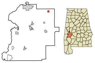
Faunsdale is a town in Marengo County, Alabama, United States. At the 2020 census the population was 90, down from 98 in 2010. Faunsdale is home to a community of Holdeman Mennonites, the such community outside of Greensboro, Alabama. The town has the only Holdeman Mennonite Church in the area, Cedarcrest Mennonite Church.

Sweet Water is a town in Marengo County, Alabama, United States. It was founded during the 1840s and named for Sweet Water Creek, which runs through a section of the community. The population was 228 at the 2020 census, down from 258 at the 2010 census.

Thomaston is a town in Marengo County, Alabama, United States. At the 2020 census the population was 326, down from 417 at the 2010 census.

Guilford is an unincorporated community located in Howard County in the state of Maryland. The location is named after the Guilford Mill. Guilford is near Kings Contrivance, one of the nine "villages" of Columbia.
Cross Roads is an unincorporated community in southwestern Henderson County, Texas, United States.
Hell's Half Acre, Hell's Half-Acre, Hell's Half-acre, or Hell's Halfacre may refer to:

Dixons Mills is an unincorporated community in Marengo County, Alabama, United States. The community was named for a group of mills operated by Joel B. Dixon in the 19th century. Dixons Mills has a post office utilizing the 36736 ZIP code.
The Autrey Mill Nature Preserve & Heritage Center is located in Johns Creek, Georgia, U.S.A.
Old Spring Hill is an unincorporated community in Marengo County, Alabama, United States.

Vineland is an unincorporated community in the southeastern corner of Marengo County, Alabama, United States. Vineland had several stores, a cotton gin, and Baptist and Methodist churches. It also had a post office from 1887 to 1916, with Julius A. Kimbrough serving as the first postmaster and Solomon S. Strickland as the last. This general area, which also included Surginer and Hampden, was originally known as Pineville Precinct. Pineville was also an early name for Putnam, in the southwestern corner of the county.
Octagon is an unincorporated community in Marengo County, Alabama, United States. Octagon had a post office at one time, but it no longer exists.
McKinley is an unincorporated community in Marengo County, Alabama, United States. McKinley had a post office at one time, but it no longer exists. Although a thriving community in its earliest years, it has since dwindled into obscurity.
Consul is an unincorporated community in Marengo County, Alabama, United States. Consul had a post office at one time, but it no longer exists.
Hoboken is an unincorporated community in Marengo County, Alabama, United States. A post office operated under the name Hoboken from 1877 to 1887.
Hugo is an unincorporated community in Marengo County, Alabama, United States. Hugo had a post office at one time, but it no longer exists.

Beaver is an unincorporated community in Whitewater Township, Winona County, Minnesota, United States, located near the junction of State Highway 74 and Winona County Road 30. Nearby places include Altura, Elba, Plainview, St. Charles, Weaver, and Whitewater State Park. The Whitewater River and Beaver Creek both flow through the area.

Sweet Water High School is a public high school that educates grades K–12 in the town of Sweet Water, Alabama, United States. It is one of three K–12 schools operated by the Marengo County School District. Sweet Water High School is accredited by the Southern Association of Colleges and Schools. Enrollment for the 2021-2022 school year was 558.
Beaver Creek is an unincorporated community in Marengo County, Alabama, United States. Its name is derived from the nearby Beaver Creek and the local church, Beaver Creek Baptist Church. Beaver Creek had a school at one time, but it was consolidated into Sweet Water High School in the 1920s.


