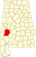
Putnam, Alabama

Last updated

Putnam, Alabama
Marengo County Alabama Incorporated and Unincorporated areas Putnam Highlighted 0162952.svg
USA Alabama location map.svg
Red pog.svg
Putnam
Usa edcp location map.svg
Red pog.svg
Putnam
Coordinates: 32°1′22.8″N88°1′51.6″W / 32.023000°N 88.031000°W / 32.023000; -88.031000
Country United States
State Alabama
County Marengo
Area
[1]
  Total9.48 sq mi (24.6 km2)
  Land9.48 sq mi (24.6 km2)
  Water0.00 sq mi (0.0 km2)
Elevation
226 ft (69 m)
Population
 (2020) [2]
  Total172
  Density18.13/sq mi (7.00/km2)
Time zone UTC-6 (Central (CST))
  Summer (DST) UTC-5 (CDT)
Area code 334
FIPS code 01-62952

Putnam is an unincorporated community and census-designated place (CDP) in Marengo County, Alabama, United States. [3] As of the 2020 census, its population was 172. [2]

Contents

Geography

Putnam is located at 32°01′23″N88°01′52″W / 32.023°N 88.031°W / 32.023; -88.031 and has an elevation of 226 feet (69 m). [3] The community is in the southwest corner of Marengo County, along Alabama State Route 69. It is 28 miles (45 km) southwest of Linden, the county seat, and 24 miles (39 km) north of Coffeeville.

According to the U.S. Census Bureau, the Putnam CDP has an area of 9.5 square miles (25 km2), all of it recorded as land. It is bordered to the north by Horse Creek and to the south by Big Bunny Creek, west-flowing tributaries of the Tombigbee River.

Demographics

Historical population
CensusPop.Note
2010 193
2020 172−10.9%
U.S. Decennial Census [4]

As of the 2010 United States Census, there were 193 people living in the CDP. The racial makeup of the CDP was 72.5% Black, 23.3% White, 2.6% Native American and 1.6% from two or more races.

Related Research Articles

<span class="mw-page-title-main">Marengo County, Alabama</span> County in Alabama, United States

Marengo County is a county located in the west central portion of the U.S. state of Alabama. As of the 2020 census, the population was 19,323. The largest city is Demopolis, and the county seat is Linden. It is named in honor of the Battle of Marengo near Turin, Italy, where French leader Napoleon Bonaparte defeated the Austrians on June 14, 1800.

<span class="mw-page-title-main">Willow Street, Pennsylvania</span> Census-designated place in Pennsylvania, United States

Willow Street is an unincorporated community and census-designated place (CDP) in Lancaster County, Pennsylvania, United States. The population was 7,578 at the 2010 census. In the early part of the 20th century, the main thoroughfare in town was lined with willow trees on both sides for the length of the town, hence the community's name. As time passed and the town grew, the road was widened and sidewalks were installed, which required the trees be removed. Only a few of the original trees remain to this day.

<span class="mw-page-title-main">Vina, Alabama</span> Town in Alabama, United States

Vina is a town in Franklin County, Alabama, United States. At the 2010 census the population was 358, down from 400 in 2000.

<span class="mw-page-title-main">Dayton, Alabama</span> Town in Alabama, United States

Dayton is a town in Marengo County, Alabama, United States. The population was 28 at the 2020 census.

<span class="mw-page-title-main">Linden, Alabama</span> City in Alabama, United States

Linden is a city in and the county seat of Marengo County, Alabama, United States. The population was 1,930 at the 2020 census, down from 2,123 at the 2010 census.

<span class="mw-page-title-main">Myrtlewood, Alabama</span> Town in Alabama, United States

Myrtlewood is a town in Marengo County, Alabama, United States. At the 2020 census the population was 70, down from 130 in 2010.

<span class="mw-page-title-main">Sweet Water, Alabama</span> Town in Alabama, United States

Sweet Water is a town in Marengo County, Alabama, United States. It was founded during the 1840s and named for Sweet Water Creek, which runs through a section of the community. The population was 228 at the 2020 census, down from 258 at the 2010 census.

<span class="mw-page-title-main">Thomaston, Alabama</span> Town in Alabama, United States

Thomaston is a town in Marengo County, Alabama, United States. At the 2020 census the population was 326, down from 417 at the 2010 census.

<span class="mw-page-title-main">Bear Creek, Alaska</span> Census-designated place in Alaska, United States

Bear Creek is a census-designated place (CDP) in Kenai Peninsula Borough, Alaska, United States. At the 2020 census the population was 2,129 up from 1,956 in 2010. Bear Creek is a few miles north of Seward near the stream of the same name and its source, Bear Lake.

<span class="mw-page-title-main">Marion, Mississippi</span> Town in Mississippi, United States

Marion is a town in Lauderdale County, Mississippi, United States. It is a northeastern suburb of Meridian, the county seat. The population of Marion was 1,479 at the 2010 census.

<span class="mw-page-title-main">Spring Creek, Nevada</span> CDP in Nevada, United States

Spring Creek is a census-designated place (CDP) in central Elko County, in northeastern Nevada in the western United States. It mainly serves as a bedroom community for the businesses and industries in and around the nearby city of Elko. It is part of the Elko Micropolitan Statistical Area. The population was 12,361 at the 2010 census.

<span class="mw-page-title-main">Collinsville, Mississippi</span> Census-designated place in Mississippi, United States

Collinsville is an unincorporated community and census-designated place (CDP) in Lauderdale County, Mississippi, United States. The population was 1,984 at the 2020 census.

<span class="mw-page-title-main">Reedsville, Pennsylvania</span> Census-designated place in Pennsylvania, United States

Reedsville is a census-designated place (CDP) in the Kishacoquillas Valley of Mifflin County, Pennsylvania, United States. The population was 641 at the 2010 census. Reedsville has a high Amish population.

<span class="mw-page-title-main">Mountville, South Carolina</span> Census-designated place in South Carolina, United States

Mountville is an unincorporated community and census-designated place (CDP) in Laurens County, South Carolina, United States. The population was 108 at the 2010 census, down from 130 at the 2000 census. It is part of the Greenville–Mauldin–Easley Metropolitan Statistical Area.

<span class="mw-page-title-main">Pine Plains (CDP), New York</span> Census-designated place in New York, United States

Pine Plains is a hamlet and census-designated place (CDP) in Dutchess County, New York, United States. The population was 1,142 at the 2020 census. It is part of the Poughkeepsie–Newburgh–Middletown, NY Metropolitan Statistical Area as well as the larger New York–Newark–Bridgeport, NY-NJ-CT-PA Combined Statistical Area.

<span class="mw-page-title-main">Nanafalia, Alabama</span> Unincorporated community in Alabama, United States

Nanafalia is an unincorporated community and census-designated place (CDP) in Marengo County, Alabama, United States. As of the 2020 census, its population was 75, down from 94 at the 2010 census. The community is located on a ridge above the Tombigbee River, and the name is derived from the Choctaw words for long hill. Nanafalia has a post office with a zip code of 36764.

<span class="mw-page-title-main">Bucks, Alabama</span> Census-designated place in Alabama, United States

Bucks is an unincorporated community and census-designated place (CDP) in Mobile County, Alabama, United States. As of the 2020 census, its population was 22, down from 32 at the 2010 census. It is located in the northeastern section of the county near the Mobile River, along U.S. Route 43. The James M. Barry Electric Generating Plant, a coal- and natural gas-fired power station operated by Alabama Power, is located in Bucks.

<span class="mw-page-title-main">Chunchula, Alabama</span> Census-designated place in Alabama, United States

Chunchula is an unincorporated community and census-designated place (CDP) in Mobile County, Alabama, United States. As of the 2020 census, its population was 195. It has a post office with the 36521 ZIP code. The community has one site listed on the Alabama Register of Landmarks and Heritage, the Chunchula School.

<span class="mw-page-title-main">Joppa, Alabama</span> Census-designated place in Alabama, United States

Joppa is a census-designated place (CDP) and unincorporated community in Cullman and Marshall counties, Alabama, United States. As of the 2020 census, its population was 556.

<span class="mw-page-title-main">Waldoboro (CDP), Maine</span> Census-designated place in Maine, United States

Waldoboro is a census-designated place (CDP) comprising the central village in the town of Waldoboro in Lincoln County, Maine, United States. The population was 1,300 at the 2020 census, out of 5,075 people in the entire town of Waldoboro.

References

  1. "2021 U.S. Gazetteer Files". United States Census Bureau. Retrieved April 11, 2022.
  2. 1 2 "Putnam CDP, Alabama: 2020 DEC Redistricting Data (PL 94-171)". U.S. Census Bureau. Retrieved April 11, 2022.
  3. 1 2 "Putnam, Alabama". AL HomeTownLocator. Retrieved December 5, 2008.
  4. "Census of Population and Housing". Census.gov. Retrieved June 4, 2016.