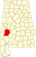
Myrtlewood, Alabama | |
---|---|
Coordinates: 32°14′50″N87°56′50″W / 32.24722°N 87.94722°W | |
Country | United States |
State | Alabama |
County | Marengo |
Area | |
• Total | 2.60 sq mi (6.7 km2) |
• Land | 2.60 sq mi (6.7 km2) |
• Water | 0.00 sq mi (0.0 km2) |
Elevation | 220 ft (70 m) |
Population | |
• Total | 70 |
• Density | 26.97/sq mi (10.41/km2) |
Time zone | UTC-6 (Central (CST)) |
• Summer (DST) | UTC-5 (CDT) |
ZIP code | 36763 |
Area code | 334 |
FIPS code | 01-53112 |
GNIS feature ID | 0123626 |
Myrtlewood is a town in Marengo County, Alabama, United States. At the 2020 census the population was 70, [2] down from 130 in 2010.
A post office has been in operation at Myrtlewood since 1886. [3] Myrtlewood was incorporated as a town in 1957. The town was named for a grove of crepe myrtle trees near the original town site. [4]
Myrtlewood is located in western Marengo County at 32°14′50″N87°56′50″W / 32.24722°N 87.94722°W (32.247254, -87.947141), [5] along Alabama State Route 114. It is 11 miles (18 km) southwest of Linden, the county seat, and 7 miles (11 km) northeast of Pennington in Choctaw County.
According to the U.S. Census Bureau, the town has a total area of 2.6 square miles (6.7 km2), all land. [1] The town sits on high ground 100 feet (30 m) above the valley of the Tombigbee River, which flows southwards 3 miles (5 km) to the west.
Census | Pop. | Note | %± |
---|---|---|---|
1960 | 403 | — | |
1970 | 334 | −17.1% | |
1980 | 252 | −24.6% | |
1990 | 197 | −21.8% | |
2000 | 139 | −29.4% | |
2010 | 130 | −6.5% | |
2020 | 70 | −46.2% | |
U.S. Decennial Census [6] 2013 Estimate [7] |
As of the census [8] of 2000, there were 139 people, 59 households, and 45 families residing in the town. The population density was 53.6 inhabitants per square mile (20.7/km2). There were 76 housing units at an average density of 29.3 per square mile (11.3/km2). The racial makeup of the town was 79.14% White and 20.86% Black or African American. 0.72% of the population were Hispanic or Latino of any race.
There were 59 households, out of which 22.0% had children under the age of 18 living with them, 61.0% were married couples living together, 10.2% had a female householder with no husband present, and 23.7% were non-families. 23.7% of all households were made up of individuals, and 6.8% had someone living alone who was 65 years of age or older. The average household size was 2.36 and the average family size was 2.76.
In the town, the population was spread out, with 18.7% under the age of 18, 5.8% from 18 to 24, 25.9% from 25 to 44, 30.2% from 45 to 64, and 19.4% who were 65 years of age or older. The median age was 44 years. For every 100 females, there were 95.8 males. For every 100 females age 18 and over, there were 98.2 males.
The median income for a household in the town was $42,188, and the median income for a family was $50,114. Males had a median income of $51,667 versus $31,250 for females. The per capita income for the town was $21,262. There were 4.8% of families and 7.3% of the population living below the poverty line, including 7.1% of under eighteens and 13.0% of those over 64.
Marengo County is a county located in the west central portion of the U.S. state of Alabama. As of the 2020 census, the population was 19,323. The largest city is Demopolis, and the county seat is Linden. It is named in honor of the Battle of Marengo near Turin, Italy, where French leader Napoleon Bonaparte defeated the Austrians on June 14, 1800.
Perry County is a county located in the Black Belt region in the central part of the U.S. state of Alabama. As of the 2020 census, the population was 8,511. Its county seat is Marion. The county was established in 1819 and is named in honor of Commodore Oliver Hazard Perry of Rhode Island and the United States Navy. As of 2020, Perry County was the only county in Alabama, and one of 40 in the United States, not to have access to any wired broadband connections.
Union is a town in rural Greene County, Alabama, United States. Per the 2020 census, the population was 180. According to the 1980 U.S. Census, it was incorporated in the 1970s.
Akron is a town in Hale County, Alabama, United States. In 1906, the owner of a large plantation, Waller Evan Wedgworth, sold part of his land to developers, and a construction boom followed. The town was incorporated in March 1918. At the 2010 census the population was 356, down from 521 at the 2000 census. Akron has one site on the National Register of Historic Places, the Greek Revival cottage known as Tanglewood.
Moundville is a town in Hale and Tuscaloosa counties in the U.S. state of Alabama. It was incorporated on December 22, 1908. From its incorporation until the 1970 census, it was wholly within Hale County. At the 2010 census the population was 2,427, up from 1,809 at the 2000 census. It is part of the Tuscaloosa Metropolitan Statistical Area. Within the town is Moundville Archaeological Site, the location of a prehistoric Mississippian culture political and ceremonial center.
Dayton is a town in Marengo County, Alabama, United States. The population was 28 at the 2020 census.
Faunsdale is a town in Marengo County, Alabama, United States. At the 2020 census the population was 90, down from 98 in 2010. Faunsdale is home to a community of Holdeman Mennonites, the only such community outside of Greensboro, Alabama. The town has the only Holdeman Mennonite Church in the area, Cedarcrest Mennonite Church.
Linden is a city in and the county seat of Marengo County, Alabama, United States. The population was 1,930 at the 2020 census, down from 2,123 at the 2010 census.
Providence is a town in Marengo County, Alabama, United States. As of the 2020 United States census, the population was 167, down from 223 at the 2010 census. It incorporated sometime in the 1970s.
Sweet Water is a town in Marengo County, Alabama, United States. It was founded during the 1840s and named for Sweet Water Creek, which runs through a section of the community. The population was 228 at the 2020 census, down from 258 at the 2010 census.
Thomaston is a town in Marengo County, Alabama, United States. At the 2020 census the population was 326, down from 417 at the 2010 census.
Chuathbaluk is a city in Bethel Census Area, Alaska, United States.
Derby Acres is a census-designated place (CDP) in Kern County, California, United States. Derby Acres is located 5.5 miles (8.9 km) north-northwest of Fellows, at an elevation of 1,375 feet (419 m). The population was 322 at the 2010 census, down from 376 at the 2000 census. The town is on State Route 33 at the northern extremity of the Midway-Sunset Oil Field, about five miles (8 km)five miles southeast of McKittrick.
Illiopolis is a village in Sangamon County, Illinois, United States. The population was 891 at the 2010 census. It is part of the Springfield, Illinois Metropolitan Statistical Area.
Sutcliffe is a census-designated place (CDP) in Washoe County, Nevada, United States. The population was 253 at the 2010 census. It is part of the Reno–Sparks Metropolitan Statistical Area.
Scotia is a town in Hampton County, South Carolina, United States. The population was 215 at the 2010 census.
Sandy Hollow-Escondidas is a census-designated place (CDP) in Nueces County, Texas, United States. The population was 296 at the 2010 census, down from 433 at the 2000 census.
Toms Brook is a town in Shenandoah County, Virginia, United States. The population was 258 at the 2010 census.
Fairview is a town in Marion County, West Virginia, United States. The population was 374 at the 2020 census.
Lee is a census-designated place (CDP) located in the town of Lee in Berkshire County, Massachusetts, United States. The population was 2,051 at the 2010 census, out of 5,943 in the entire town of Lee.