Elba, Alabama

Last updated

Elba
Coffee County Courthouse.jpg
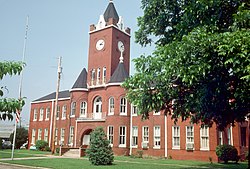
Coffee County Courthouse in Elba
Nickname: 
The City of Flowing Wells
Coffee County Alabama Incorporated and Unincorporated areas Elba Highlighted 0123296.svg
Location of Elba in Coffee County, Alabama.
Coordinates: 31°25′2″N86°4′38″W / 31.41722°N 86.07722°W / 31.41722; -86.07722
Country United States
State Alabama
County Coffee
SettledEarly 1830s
IncorporatedApril 13, 1853
Government
  TypeCity Council/Mayor
  MayorTom Maddox
Area
[1]
  Total15.42 sq mi (39.93 km2)
  Land15.34 sq mi (39.73 km2)
  Water0.08 sq mi (0.21 km2)
Elevation
194 ft (59 m)
Population
 (2020)
  Total3,508
  Density228.71/sq mi (88.31/km2)
Time zone UTC-6 (Central (CST))
  Summer (DST) UTC-5 (CDT)
ZIP code
36323
Area code 334
FIPS code 01-23296
GNIS feature ID0117908
Website www.elbaal.gov

Elba is a city in and the county seat of Coffee County, Alabama, United States. It is the official seat, although there are two county courthouses, with the other one being located in the city of Enterprise. At the time of the 2010 U.S. census, Elba's population was 3,940. [2] Elba is part of the Enterprise micropolitan statistical area.

Contents

History

The town which eventually became Elba originated near a ferry across the Pea River in the early 1830s. Originally called Bridgeville, a U.S. post office was established in the town by 1841. In 1851, a lottery to determine a new name for the town was held. One citizen had been reading a biography of Napoleon Bonaparte, and his suggestion of "Elba" as its name was the winner when it was drawn from a hat before any of the other suggestions. Elba became the county seat of Coffee County in 1852. [3]

A logging railroad first reached Elba on March 20, 1892, with the first permanent rail line arriving in October 1898. The "Dorsey Trailer Company" was constructed at the end of this railroad line, and this company manufactured the highway trailers that served on railroads and highways starting with the piggyback railroad or containerized cargo boom of the second half of the 20th century. The new railroad line ended in West Elba, where the "New Town" industrial section of the town was located. The Seaboard System Railroad ceased all railroad service to Elba, including freight service, on November 27, 1984. [4]

The Pea River is an essential component of the history of Elba. The river was originally called the Talakatchee River by the Creek Indians. (In the Creek language, talak means "pea", and hatchee means "small river".) The Pea River frequently flooded, causing great damage to the town. The Lincoln flood of 1865, named for the assassination of Abraham Lincoln in the same year, was the first to destroy the town. Another devastating flood occurred in 1929 when the river crested at a depth of 43.5 feet (13.3 m) early on March 15. Airplanes were used to drop supplies to the completely inundated town. There was only one death from the flood, an African-American man named "Phoe" Larkins. A child born at the Elba Hotel during this flood was named "Noah Tucker" after the biblical character Noah. Vivian Harper received the Theodore N. Vail Silver Medal for her heroic actions during the flood. [4]

A levee was built around the town in 1930. Flood gates were erected and drainage systems improved. Floods continued, however, with especially severe inundations in 1938, 1959 and 1975. The worst flood ever recorded in Elba occurred in 1990, with a river crest of 48 feet (15 m). The levee broke and Whitewater Creek overflowed into the town. Elba was completely flooded for four days, and the town was nearly destroyed. More floods struck Elba in 1994 and 1998. [4]

Geography

Elba is located in western Coffee County at 31°25′2″N86°4′39″W / 31.41722°N 86.07750°W / 31.41722; -86.07750 (31.417263, -86.077442). [5]

U.S. Route 84 runs from west to east as a northern bypass of the city, leading east 9 mi (14 km) to New Brockton and southwest 16 mi (26 km) to Opp. Many state highways run through the city as well, namely Alabama State Routes 87, 125, 189, and 203. AL-203 forms the western bypass of the city. AL-87 runs from south to north through the center of the city, leading north 30 mi (48 km) to Troy and south 24 mi (39 km) to Samson. AL-189 runs to the west of the city from south to north, leading northwest 16 mi (26 km) to U.S. Route 331 near Brantley and southwest 17 mi (27 km) to Kinston. AL-125 runs northeast from the city 13 mi (21 km) to the community of Victoria.

According to the U.S. Census Bureau, the city has a total area of 15.4 square miles (39.9 km2), of which 15.3 square miles (39.7 km2) is land and 0.077 square miles (0.2 km2), or 0.52%, is water. [6]

Elba is located beside the banks of the Pea River.

Climate

The climate in this area is characterized by hot, humid summers and generally mild to cool winters. According to the Köppen Climate Classification system, Elba has a humid subtropical climate, abbreviated "Cfa" on climate maps. [7]

Climate data for Elba, 1991–2020 simulated normals (190 ft elevation)
MonthJanFebMarAprMayJunJulAugSepOctNovDecYear
Mean daily maximum °F (°C)60.6
(15.9)
64.6
(18.1)
71.8
(22.1)
78.4
(25.8)
85.6
(29.8)
90.3
(32.4)
91.9
(33.3)
91.4
(33.0)
88.0
(31.1)
80.1
(26.7)
70.2
(21.2)
63.0
(17.2)
78.0
(25.5)
Daily mean °F (°C)48.7
(9.3)
52.2
(11.2)
59.0
(15.0)
65.7
(18.7)
73.4
(23.0)
79.5
(26.4)
81.9
(27.7)
81.3
(27.4)
75.4
(24.1)
67.3
(19.6)
57.0
(13.9)
51.3
(10.7)
66.1
(18.9)
Mean daily minimum °F (°C)36.7
(2.6)
39.9
(4.4)
46.4
(8.0)
52.9
(11.6)
61.0
(16.1)
68.9
(20.5)
71.8
(22.1)
71.2
(21.8)
66.4
(19.1)
54.7
(12.6)
43.9
(6.6)
39.6
(4.2)
54.5
(12.5)
Average precipitation inches (mm)5.35
(135.80)
4.91
(124.68)
5.23
(132.88)
4.83
(122.78)
3.79
(96.16)
5.55
(140.89)
6.58
(167.10)
5.49
(139.57)
6.57
(166.77)
3.47
(88.24)
4.04
(102.61)
5.21
(132.43)
61.02
(1,549.91)
Average dew point °F (°C)39.2
(4.0)
42.1
(5.6)
46.9
(8.3)
53.6
(12.0)
61.3
(16.3)
68.5
(20.3)
71.8
(22.1)
71.6
(22.0)
67.1
(19.5)
56.5
(13.6)
47.1
(8.4)
42.6
(5.9)
55.7
(13.2)
Source: PRISM Climate Group [8]

Demographics

Historical population
CensusPop.Note
1880 222
1890 28528.4%
1900 635122.8%
1910 1,07969.9%
1920 1,68155.8%
1930 2,52350.1%
1940 2,363−6.3%
1950 2,93624.2%
1960 4,32147.2%
1970 4,6347.2%
1980 4,355−6.0%
1990 4,011−7.9%
2000 4,1854.3%
2010 3,940−5.9%
2020 3,508−11.0%
U.S. Decennial Census [9]
2013 Estimate [10]

2020 census

Elba racial composition [11]
RaceNum.Perc.
White (non-Hispanic)1,99456.84%
Black or African American (non-Hispanic)1,27036.2%
Native American 230.66%
Asian 20.06%
Other/Mixed 1454.13%
Hispanic or Latino 742.11%

As of the 2020 United States census, there were 3,508 people, 1,427 households, and 917 families residing in the city.

2010 census

As of the census [12] of 2010, there were 3,940 people, 1,547 households, and 991 families residing in the city. The population density was 257 inhabitants per square mile (99/km2). There were 1,772 housing units at an average density of 115 per square mile (44/km2). The racial makeup of the city was 62.1% White, 34.3% Black or African American, 1.2% Native American, 0.3% Asian, 0.2% Pacific Islander, 0.8% from other races, and 1.2% from two or more races. 1.1% of the population were Hispanic or Latino of any race.

There were 1,547 households, out of which 25.3% had children under the age of 18 living with them, 39.9% were married couples living together, 19.8% had a female householder with no husband present, and 35.9% were non-families. 32.6% of all households were made up of individuals, and 15.5% had someone living alone who was 65 years of age or older. The average household size was 2.34 and the average family size was 2.97.

In the city, the population was spread out, with 22.0% under the age of 18, 8.1% from 18 to 24, 24.9% from 25 to 44, 25.4% from 45 to 64, and 19.6% who were 65 years of age or older. The median age was 40.9 years. For every 100 females, there were 98.0 males. For every 100 females age 18 and over, there were 110.9 males.

The median income for a household in the city was $28,975, and the median income for a family was $32,065. Males had a median income of $31,652 versus $21,786 for females. The per capita income for the city was $14,878. About 27.6% of families and 27.1% of the population were below the poverty line, including 40.4% of those under age 18 and 17.8% of those age 65 or over.

Education

Public education is provided by the Elba City Public School District. There are two schools in the city:

Elba High School (grades 7 through 12)
Elba Elementary School (grades K through 6)

Media

WZTZ 101.1 FM (Sports)

Notable people

Related Research Articles

<span class="mw-page-title-main">Coffee County, Alabama</span> County in Alabama, United States

Coffee County is a county located in the southeastern part of the U.S. state of Alabama. As of the 2020 census, the population was 53,465. Its name is in honor of General John Coffee.

<span class="mw-page-title-main">Autaugaville, Alabama</span> Town in Alabama, United States

Autaugaville is a town in Autauga County, Alabama, United States. At the 2020 census, the population was 795. It is part of the Montgomery Metropolitan Statistical Area.

<span class="mw-page-title-main">Billingsley, Alabama</span> Village in Alabama, United States

Billingsley is a village in Autauga County, Alabama, United States. At the 2020 census, the population was 125. It is part of the Montgomery Metropolitan Statistical Area.

<span class="mw-page-title-main">Garden City, Alabama</span> Town in Alabama, United States

Garden City is a town in Cullman and Blount counties in the U.S. state of Alabama. At the 2020 census, the population was 528. Garden City was founded by Johann Cullmann, namesake of Cullman County in 1873 after founding Cullman, Alabama. It was located in Blount County and was incorporated in 1878. Cullman County was created in 1877. Garden City was annexed by Cullman County with a shift in county borders until 1901. After a lapse in its incorporation, it was re-incorporated in 1950.

<span class="mw-page-title-main">Calera, Alabama</span> City in Alabama, United States

Calera is a city in Shelby and Chilton counties in the U.S. state of Alabama. It is the location of the Shelby County Airport.

<span class="mw-page-title-main">Maplesville, Alabama</span> Town in Alabama, United States

Maplesville is a town in Chilton County, Alabama, United States. At the 2020 census, the population was 637. It is located approximately halfway between Tuscaloosa and Montgomery on U.S. Route 82.

<span class="mw-page-title-main">New Brockton, Alabama</span> Town in Alabama, United States

New Brockton is a town in Coffee County, Alabama, United States. At the 2020 census, the population was 1,428. The community was named for Huey E. Brock, a settler who came to the region in 1871.

<span class="mw-page-title-main">Andalusia, Alabama</span> City in and county seat of Covington County, Alabama

Andalusia is a city in and the county seat of Covington County, Alabama, United States. At the 2020 census, the population was 8,805.

<span class="mw-page-title-main">Opp, Alabama</span> City in Alabama, United States

Opp is a city in Covington County, Alabama, United States. At the 2020 census, the population was 6,771. Opp is named after Henry Opp, a lawyer for the Louisville and Nashville Railroad.

<span class="mw-page-title-main">Brantley, Alabama</span> Town in Alabama, United States

Brantley is a city in Crenshaw County, Alabama, United States. At the 2020 census, the population was 825. Brantley was incorporated in 1891 as a city.

<span class="mw-page-title-main">Luverne, Alabama</span> City in Alabama, United States

Luverne is a city in and the county seat of Crenshaw County, Alabama, United States. The city describes itself as "The Friendliest City in the South", a slogan that appears on its "welcome" signs. At the 2020 census, the population was 2,765.

<span class="mw-page-title-main">Geneva, Alabama</span> City in Alabama, United States

Geneva is a city in and the county seat of Geneva County, Alabama, United States. It was incorporated in 1875. It is part of the Dothan, Alabama Metropolitan Statistical Area. Since 1940, it has been the largest city of Geneva County, and had a population of 4,292 as of the 2020 census.

<span class="mw-page-title-main">Langston, Alabama</span> Town in Alabama, United States

Langston is a town in Jackson County, Alabama, United States, and is included in the Chattanooga-Cleveland-Dalton, TN-GA-AL Combined Statistical Area. In the 2010 census, the population was 270, up from 254. It initially incorporated in 1899. At some point after 1920 it disincorporated, then reincorporated in 1980. Its peak population was 500, in 1920.

<span class="mw-page-title-main">Falkville, Alabama</span> Town in Alabama, United States

Falkville is a town in Morgan County, Alabama, United States, and is included in the Decatur Metropolitan Area and Huntsville-Decatur Combined Statistical Area. As of the 2020 census, the population of the town was 1,197.

<span class="mw-page-title-main">Wilsonville, Alabama</span> Town in Alabama, United States

Wilsonville is a town in southeastern Shelby County, Alabama, United States, located northeast of Columbiana. At the 2020 census, the population was 1,857. Wilsonville is named after the earliest settler in the area, Elisha Wilson.

<span class="mw-page-title-main">Graceville, Florida</span> City in Florida, United States

Graceville is a city in Jackson County, Florida, United States. It is near the Alabama state line. The population was 2,153 at the 2020 census.

<span class="mw-page-title-main">DeFuniak Springs, Florida</span> City in Florida, United States of America

DeFuniak Springs is a city and the county seat of Walton County, Florida, United States. The population was 6,968 as of the 2020 Census. DeFuniak Springs also serves as a hub for many residents in surrounding communities.

<span class="mw-page-title-main">New Boston, Texas</span> City in Texas, United States

New Boston is a city in Bowie County, Texas, United States. Boston was named for an early storekeeper in the settlement, W.J. Boston. The coming of the railroads led to the location of two more Bostons. A depot was built approximately four miles north of Boston and was named New Boston. The original Boston then became Old Boston. The courthouse was moved to Texarkana in the early 1880s, but a later election carried to move the courthouse back to the geographic center of the county. This location was between the Bostons. The Post Office Department named this location Boston, so Bowie County has claim to three Bostons: New Boston, Boston, and Old Boston. The population was 4,550 at the 2010 census, and 4,612 in 2020.

<span class="mw-page-title-main">Kempner, Texas</span> City in Texas, United States

Kempner is a city in Lampasas County, Texas, United States. The population was 1,146 at the 2020 census. It is part of the Killeen–Temple–Fort Hood Metropolitan Statistical Area.

<span class="mw-page-title-main">Ardmore, Tennessee</span> City in Tennessee, United States

Ardmore is a city in Giles and Lincoln counties, Tennessee, United States. The population was 1,217 at the 2020 census. Ardmore is the site of a Tennessee Department of Tourist Development Welcome Center. It borders its sister city, Ardmore, Alabama.

References

  1. "2020 U.S. Gazetteer Files". United States Census Bureau. Retrieved October 29, 2021.
  2. "Geographic Identifiers: 2010 Demographic Profile Data (G001): Elba city, Alabama". U.S. Census Bureau, American Factfinder. Archived from the original on February 12, 2020. Retrieved June 6, 2014.
  3. Sanford, William (September 23, 2009). "Elba". Encyclopedia of Alabama. Retrieved January 21, 2010.
  4. 1 2 3 "History of Elba". City of Elba website. Archived from the original on September 30, 2009. Retrieved January 21, 2010.
  5. "US Gazetteer files: 2010, 2000, and 1990". United States Census Bureau. February 12, 2011. Retrieved April 23, 2011.
  6. "Geographic Comparison Table- Alabama". American Fast Facts. United States Census Bureau. Archived from the original on February 12, 2020.
  7. Climate Summary for Elba, Alabama
  8. "PRISM Climate Group at Oregon State University". Northwest Alliance for Computational Science & Engineering (NACSE), based at Oregon State University. Retrieved March 14, 2023.
  9. "U.S. Decennial Census". Census.gov. Retrieved June 6, 2013.
  10. "Annual Estimates of the Resident Population: April 1, 2010 to July 1, 2013". Archived from the original on May 31, 2014. Retrieved June 3, 2014.
  11. "Explore Census Data". data.census.gov. Retrieved December 17, 2021.
  12. "U.S. Census website". United States Census Bureau . Retrieved July 18, 2015.
  13. "Banker Alpheus Lee Ellis, One of Forbes' 400 Richest, Dies at 89". AP NEWS. Associated Press. Retrieved July 17, 2021.

31°25′02″N86°04′39″W / 31.417263°N 86.077442°W / 31.417263; -86.077442