Opp | |
---|---|
Coordinates: 31°16′59″N86°15′17″W / 31.28306°N 86.25472°W | |
Country | United States |
State | Alabama |
County | Covington |
Government | |
• Mayor | Becky Bracke (R) |
Area | |
• Total | 24.59 sq mi (63.69 km2) |
• Land | 23.66 sq mi (61.29 km2) |
• Water | 0.92 sq mi (2.39 km2) |
Elevation | 338 ft (103 m) |
Population (2020) | |
• Total | 6,771 |
• Density | 286.12/sq mi (110.47/km2) |
Time zone | UTC-6 (Central (CST)) |
• Summer (DST) | UTC-5 (CDT) |
ZIP code | 36467 |
Area code | 334 |
FIPS code | 01-57120 |
GNIS feature ID | 0154482 |
Website | www |
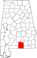
Opp is a city in Covington County, Alabama, United States. At the 2020 census, the population was 6,771. Opp is named after Henry Opp, a lawyer for the Louisville and Nashville Railroad.
Opp is located in eastern Covington County at 31°16′59″N86°15′17″W / 31.28306°N 86.25472°W (31.283083, -86.254661). [2] It is bordered by the town of Babbie to the west and the town of Horn Hill to the southwest.
U.S. Routes 84 and 331 are the main roads that pass near the city. US 84 bypasses the city to the south and east, leading northeast 16 mi (26 km) to Elba and west 16 mi (26 km) to Andalusia, the county seat of Covington County. US 331 bypasses the city to the east (with US 84), and leads north 22 mi (35 km) to Brantley and south 21 mi (34 km) to Florala, on the Florida state line. Alabama State Route 52 runs southeast 7 mi (11 km) to the town of Kinston from US 84/331.
According to the U.S. Census Bureau, the city has a total area of 24.6 square miles (63.7 km2), of which 23.7 square miles (61.3 km2) is land and 0.93 square miles (2.4 km2), or 3.76%, is water. [3]
Census | Pop. | Note | %± |
---|---|---|---|
1910 | 863 | — | |
1920 | 1,556 | 80.3% | |
1930 | 2,918 | 87.5% | |
1940 | 3,178 | 8.9% | |
1950 | 5,240 | 64.9% | |
1960 | 5,535 | 5.6% | |
1970 | 6,493 | 17.3% | |
1980 | 7,204 | 11.0% | |
1990 | 6,985 | −3.0% | |
2000 | 6,607 | −5.4% | |
2010 | 6,659 | 0.8% | |
2020 | 6,771 | 1.7% | |
U.S. Decennial Census [4] 2013 Estimate [5] |
Race | Num. | Perc. |
---|---|---|
White (non-Hispanic) | 5,091 | 75.19% |
Black or African American (non-Hispanic) | 1,211 | 17.89% |
Native American | 25 | 0.37% |
Asian | 29 | 0.43% |
Other/Mixed | 278 | 4.11% |
Hispanic or Latino | 137 | 2.02% |
As of the 2020 United States census, there were 6,771 people, 2,701 households, and 1,768 families residing in the city.
As of the census [7] of 2010, there were 6,659 people and 2,655 households, and 1,823 families residing in the city. The population density was 388 people per square mile. The racial makeup of the city was 80.9% White, 16.7% Black or African American, 0.6% Native American, 0.3% Asian, and 1.2% from two or more races. 0.9% of the population were Hispanic or Latino of any race.
In 2000, there were 2,753 households, out of which 28.4% had children under the age of 18 living with them, 50.5% were married couples living together, 14.8% had a female householder with no husband present, and 30.8% were non-families. 28.8% of all households were made up of individuals, and 15.0% had someone living alone who was 65 years of age or older. The average household size was 2.33 and the average family size was 2.85.
In the city, the population was 23.3% under the age of 18, 7.9% from 18 to 24, 24.6% from 25 to 44, 23.6% from 45 to 64, and 20.6% who were 65 years of age or older. The median age was 41 years. For every 100 females, there were 79.8 males. For every 100 females age 18 and over, there were 76.9 males. The median income for a household in the city was $26,702, and the median income for a family was $32,436. Males had a median income of $27,821 versus $21,280 for females. The per capita income for the city was $15,281. About 14.2% of families and 18.2% of the population were below the poverty line, including 28.8% of those under age 18 and 15.8% of those age 65 or over.
Opp's city slogan is "The City of OPPortunity". [8]
Covington County is a county located in the south central portion of the U.S. state of Alabama. As of the 2020 census the population was 37,570. Its county seat is Andalusia. Its name is in honor of Brigadier General Leonard Covington of Maryland and Mississippi, who died in the War of 1812.
Crenshaw County is a county located in the south central portion of the U.S. state of Alabama. It is located immediately south of the Montgomery metropolitan area. As of the 2020 census, the population was 13,194. Its county seat is Luverne. Its name is in honor of an Alabama judge, Anderson Crenshaw.
Elba is a city in and the county seat of Coffee County, Alabama, United States. It is the official seat, although there are two county courthouses, with the other one being located in the city of Enterprise. At the time of the 2010 U.S. census, Elba's population was 3,940. Elba is part of the Enterprise micropolitan statistical area.
Andalusia is a city in and the county seat of Covington County, Alabama, United States. At the 2020 census, the population was 8,805.
Babbie is a town in Covington County, Alabama, United States. At the 2020 census, the population was 625. It incorporated in 1957.
River Falls is a town in Covington County, Alabama, United States. At the 2020 census, the population was 479.
Sanford is a town in Covington County, Alabama, United States. At the 2020 census, the population was 257. Sanford was originally incorporated in 1902 and was on the 1910 U.S. Census. It did not appear again on the census until 1960.
Elmore is a town in Elmore County, Alabama, United States. Although initially incorporated in 1906, it lapsed and was not reincorporated again until 1997. At the 2010 census the population was 1,262, up from 199 in 2000. It is part of the Montgomery Metropolitan Statistical Area.
Childersburg is a city in Talladega County in the U.S. state of Alabama. It was incorporated in 1889. At the 2020 census, the population was 4,754. It has a history dating back before 1540, when it was noted as a village of the Coosa Nation visited by the Spanish explorer Hernando de Soto. It is said a member of De Soto’s crew fell ill and was left to settle in the area of present day Childersburg where the Coosa people cared for the ill explorer. The Alabama Army Ammunition Plant, important during World War II, was located 4 miles (6 km) north of Childersburg.
Wilsonville is a town in southeastern Shelby County, Alabama, United States, located northeast of Columbiana. At the 2020 census, the population was 1,857. Wilsonville is named after the earliest settler in the area, Elisha Wilson.
Gassville is a city in Baxter County, Arkansas, United States. According to the 2020 census, the city population was 2,171.
Pompano Estates is a former census-designated place (CDP) in Broward County, Florida, United States. The population was 3,367 at the 2000 census. The area has since been incorporated into the city of Deerfield Beach.
Chesterfield is a village in Macoupin County, Illinois, United States. The population was 170 at the 2020 census.
Dennistown Plantation is a plantation in Somerset County, Maine, United States. The population was 61 at the 2020 census.
Wolf Lake is an unincorporated community and census-designated place (CDP) in Muskegon County in the U.S. state of Michigan. At the 2020 census, the population of Wolf Lake was 5,034, up from 4,104 in 2010. As an unincorporated community, Wolf Lake is governed by Egelston Township.
Fayette Township is a township in Juniata County, Pennsylvania, United States. The population was 3,339 at the 2020 census.
Heidelberg Township is a township in Lebanon County, Pennsylvania, United States. The population was 4,080 at the 2020 census. It is part of the Lebanon, Pennsylvania Metropolitan Statistical Area.
Salem Township is a township in Mercer County, Pennsylvania, United States. The population was 752 at the 2020 census, down from 754 in 2010.
Hancock is a village in Delaware County, New York, United States. The population was 908 at the 2020 census. The village is in the west part of the town of Hancock at the junction of NY Routes 17 and 97.
Fort Kent is a census-designated place (CDP) that comprises the main village in the town of Fort Kent in Aroostook County, Maine, United States. In 2010, Fort Kent's population was 2,488 of 4,097 for the entire town.