Rose Hill, Alabama | |
|---|---|
 Rose Hill, Alabama  Rose Hill, Alabama | |
| Coordinates: 31°26′58″N86°20′22″W / 31.44944°N 86.33944°W | |
| Country | United States |
| State | Alabama |
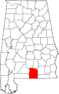
| County | Covington |
| Elevation | 433 ft (132 m) |
| Time zone | UTC-6 (Central (CST)) |
| • Summer (DST) | UTC-5 (CDT) |
| Area code | 334 |
| GNIS feature ID | 125934 [1] |
Rose Hill is an unincorporated community in Covington County, Alabama, United States.