This article needs additional citations for verification .(August 2011) |
Florala, Alabama | |
---|---|
Coordinates: 31°0′27″N86°19′29″W / 31.00750°N 86.32472°W | |
Country | United States |
State | Alabama |
County | Covington |
Area | |
• Total | 10.98 sq mi (28.44 km2) |
• Land | 10.53 sq mi (27.28 km2) |
• Water | 0.45 sq mi (1.16 km2) |
Elevation | 262 ft (80 m) |
Population (2020) | |
• Total | 1,923 |
• Density | 182.59/sq mi (70.49/km2) |
Time zone | UTC−6 (Central (CST)) |
• Summer (DST) | UTC−5 (CDT) |
ZIP code | 36442 |
Area code | 334 |
FIPS code | 01-26848 |
GNIS feature ID | 0159617 |
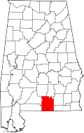
Florala is a town in Covington County, Alabama, United States. At the 2020 census, the population was 1,923.
Florala is located along the Alabama–Florida state line at 31°0′28″N86°19′30″W / 31.00778°N 86.32500°W (31.007712, -86.324957). [2] It is bordered by the town of Lockhart to the west and the town of Paxton, Florida, to the south.
According to the U.S. Census Bureau, the city has a total area of 11.0 square miles (28.4 km2), of which 10.5 square miles (27.3 km2) is land and 0.46 square miles (1.2 km2), or 4.07%, is water. [3] Lake Jackson lies on the state line, half in Florala. Florala City Park occupies all of the lake's shoreline in Alabama.
Climate data for Florala, Alabama (Florala Municipal Airport), 1991–2020 normals, extremes 2006–2020 | |||||||||||||
---|---|---|---|---|---|---|---|---|---|---|---|---|---|
Month | Jan | Feb | Mar | Apr | May | Jun | Jul | Aug | Sep | Oct | Nov | Dec | Year |
Record high °F (°C) | 83 (28) | 84 (29) | 89 (32) | 94 (34) | 99 (37) | 104 (40) | 102 (39) | 103 (39) | 103 (39) | 100 (38) | 91 (33) | 81 (27) | 104 (40) |
Mean daily maximum °F (°C) | 62.2 (16.8) | 66.2 (19.0) | 73.1 (22.8) | 79.4 (26.3) | 86.6 (30.3) | 90.3 (32.4) | 91.8 (33.2) | 91.7 (33.2) | 88.5 (31.4) | 80.0 (26.7) | 71.3 (21.8) | 63.6 (17.6) | 78.7 (26.0) |
Daily mean °F (°C) | 51.3 (10.7) | 54.7 (12.6) | 61.0 (16.1) | 67.0 (19.4) | 74.7 (23.7) | 80.1 (26.7) | 82.1 (27.8) | 82.0 (27.8) | 78.4 (25.8) | 68.4 (20.2) | 59.1 (15.1) | 52.9 (11.6) | 67.6 (19.8) |
Mean daily minimum °F (°C) | 40.5 (4.7) | 43.3 (6.3) | 48.8 (9.3) | 54.6 (12.6) | 62.7 (17.1) | 70.0 (21.1) | 72.4 (22.4) | 72.4 (22.4) | 68.3 (20.2) | 56.7 (13.7) | 46.9 (8.3) | 42.3 (5.7) | 56.6 (13.7) |
Record low °F (°C) | 16 (−9) | 20 (−7) | 28 (−2) | 35 (2) | 43 (6) | 58 (14) | 59 (15) | 62 (17) | 50 (10) | 34 (1) | 19 (−7) | 22 (−6) | 16 (−9) |
Average precipitation inches (mm) | 5.28 (134) | 5.00 (127) | 5.28 (134) | 5.00 (127) | 3.78 (96) | 6.01 (153) | 6.35 (161) | 5.17 (131) | 5.18 (132) | 3.61 (92) | 4.31 (109) | 4.85 (123) | 59.82 (1,519) |
Source 1: NOAA [4] | |||||||||||||
Source 2: XMACIS2 [5] |
Census | Pop. | Note | %± |
---|---|---|---|
1910 | 2,439 | — | |
1920 | 2,633 | 8.0% | |
1930 | 2,580 | −2.0% | |
1940 | 2,999 | 16.2% | |
1950 | 2,713 | −9.5% | |
1960 | 3,011 | 11.0% | |
1970 | 2,701 | −10.3% | |
1980 | 2,165 | −19.8% | |
1990 | 2,075 | −4.2% | |
2000 | 1,964 | −5.3% | |
2010 | 1,980 | 0.8% | |
2020 | 1,923 | −2.9% | |
U.S. Decennial Census [6] 2013 Estimate [7] |
Race | Num. | Perc. |
---|---|---|
White (non-Hispanic) | 1,481 | 77.02% |
Black or African American (non-Hispanic) | 296 | 15.39% |
Native American | 3 | 0.16% |
Asian | 11 | 0.57% |
Other/Mixed | 70 | 3.64% |
Hispanic or Latino | 62 | 3.22% |
As of the 2020 United States census, there were 1,923 people, 646 households, and 352 families residing in the town.
As of the census [9] of 2010, there were 1,980 people, 839 households, and 514 families living in the city. The population density was 180.2 inhabitants per square mile (69.6/km2). There were 1,107 housing units at an average density of 105.0 per square mile (40.5/km2). The racial makeup of the city was 80.1% White, 15.8% Black or African American, 0.8% Native American, 0.4% Asian, 0.7% from other races, and 2.3% from two or more races. 2.8% of the population were Hispanic or Latino of any race.
There were 839 households, out of which 23.5% had children under the age of 18 living with them, 38.1% were married couples living together, 17.6% had a female householder with no husband present, and 38.7% were non-families. 34.7% of all households were made up of individuals, and 17.8% had someone living alone who was 65 years of age or older. The average household size was 2.26 and the average family size was 2.90.
In the city, the population was 21.6% under the age of 18, 7.9% from 18 to 24, 18.9% from 25 to 44, 27.7% from 45 to 64, and 23.8% who were 65 years of age or older. The median age was 46.1 years. For every 100 females, there were 88.0 males. For every 100 females age 18 and over, there were 92.9 males.
The median income for a household in the city was $30,833, and the median income for a family was $36,435. Males had a median income of $24,000 versus $20,100 for females. The per capita income for the city was $16,344. About 15.7% of families and 20.2% of the population were below the poverty line, including 28.5% of those under age 18 and 15.4% of those age 65 or over.
As of the census [10] of 2000, there were 1,964 people, 898 households, and 527 families living in the city. The population density was 187.0 inhabitants per square mile (72.2/km2). There were 1,103 housing units at an average density of 105.0 per square mile (40.5/km2). The racial makeup of the city was 80.75% White, 15.68% Black or African American, 0.87% Native American, 0.61% Asian, 0.66% from other races, and 1.43% from two or more races. 2.65% of the population were Hispanic or Latino of any race.
There were 898 households, out of which 23.9% had children under the age of 18 living with them, 40.5% were married couples living together, 14.3% had a female householder with no husband present, and 41.3% were non-families. 36.4% of all households were made up of individuals, and 21.6% had someone living alone who was 65 years of age or older. The average household size was 2.19 and the average family size was 2.86.
In the city, the population was 21.8% under the age of 18, 7.8% from 18 to 24, 24.6% from 25 to 44, 24.2% from 45 to 64, and 21.5% who were 65 years of age or older. The median age was 42 years. For every 100 females, there were 82.5 males. For every 100 females age 18 and over, there were 76.3 males. The median income for a household in the city was $17,377, and the median income for a family was $21,176. Males had a median income of $27,569 versus $15,625 for females. The per capita income for the city was $11,495. About 29.3% of families and 32.4% of the population were below the poverty line, including 38.8% of those under age 18 and 26.6% of those age 65 or over.
The name is a portmanteau of Florida and Alabama.
In 1818, Andrew Jackson stopped at the lake with his soldiers, and thus Lake Jackson is named after him. Since 1870, Florala has served as the home of the world's oldest consecutive annual Masonic Day celebration, through Florala's Fidelity Masonic Lodge #685 (beginning with Chapel Hill and Lake City Lodge #377), and Chapter #441 of the Order of the Eastern Star. The celebration is in honor of St. John's Day, June 24, 1717, when the first Grand Masonic Lodge in England was established. The celebration is held each year on the Friday before June 24 and concluding on the Saturday after the 24th.
Morgan County is a county in the north-central part of the U.S. state of Alabama. As of the 2020 census, its population was 123,421. The county seat is Decatur. On June 14, 1821, it was renamed in honor of American Revolutionary War General Daniel Morgan of Virginia. It is a prohibition or dry county, although alcohol sales are allowed in the cities of Decatur, Hartselle, and Priceville. Morgan County is included in the Decatur, AL Metropolitan Statistical Area, which is also included in the Huntsville-Decatur-Albertville, AL Combined Statistical Area. It is a part of the North, Northwest, and North-Central regions of Alabama.
Coosa County is a county located in the east central portion of the U.S. state of Alabama. As of the 2020 census the population was 10,387. Its county seat is Rockford. Its name derives from a town of the Creek tribe and the Coosa River, which forms one of the county borders.
Covington County is a county located in the south central portion of the U.S. state of Alabama. As of the 2020 census the population was 37,570. Its county seat is Andalusia. Its name is in honor of Brigadier General Leonard Covington of Maryland and Mississippi, who died in the War of 1812.
Lockhart is a town in Covington County, Alabama, United States. At the 2020 census, the population was 445.
Opp is a city in Covington County, Alabama, United States. At the 2020 census, the population was 6,771. Opp is named after Henry Opp, a lawyer for the Louisville and Nashville Railroad.
Good Hope is a city in Cullman County, Alabama, United States. As of the 2010 census, the population of the city was 2,264. It incorporated in April 1962.
Hanceville is a city in Cullman County, Alabama, United States. At the 2020 census, the population was 3,217.
Deatsville is a town in Elmore County, Alabama, United States. Although Deatsville initially incorporated in 1903, it lapsed at some point after the 1910 U.S. Census and did not appear again as incorporated until 2000. As of the 2020 census, the population was 1,679.
Sardis City is a town in Etowah and Marshall counties in the U.S. state of Alabama. It is part of the Gadsden Metropolitan Statistical Area. It originally incorporated in May 1963 under the name of "Sardis". It became Sardis City in the 1980s. At the 2020 census, the population was 1,814.
Argo is a city in Jefferson and St. Clair counties, Alabama, United States. It incorporated in 1987. At the 2020 census, the population was 4,368.
Graysville is a city in northwestern Jefferson County, Alabama, United States, located north of Adamsville. At the 2020 census, the population was 1,950.
Midfield is a town in Jefferson County, Alabama, United States, located two miles south of the Birmingham suburb of Fairfield. It incorporated in 1953. As of the 2020 census, it had a population of 5,211.
Tarrant is a city in Jefferson County, Alabama, bordering Birmingham's north side. At the 2020 census, the population was 6,124. It is home to the ABC Coke plant owned by the Drummond Company, "the largest single producer of foundry coke in the U.S.".
New Hope is a city in Madison County, Alabama, United States, and is included in the Huntsville-Decatur Combined Statistical Area. The population was 2,889 at the 2020 census.
Hartselle is the second largest city in Morgan County, Alabama, United States, 13 miles (21 km) south of Decatur. It is part of the Decatur Metropolitan Area and the Huntsville-Decatur Combined Statistical Area.
Pelham is a city in Shelby County, Alabama, United States. The population was 24,318 at the 2020 census, It incorporated on July 10, 1964 and is a suburb located in the Birmingham metropolitan area, Alabama which was home to nearly 1.2 million residents as of the 2020 census. It was named for Confederate Civil War officer John Pelham.
Margaret is a city in St. Clair County, Alabama, United States. At the 2020 census, the population was 5,106. As of the 2010 census, the population is 4,428, an increase of 278.8%. Margaret incorporated in 1960 and became a city in October 2011.
Springville is a city in St. Clair County, Alabama, United States. It incorporated in December 1880. At the 2020 census the population was 4,786, up from 4,080 in 2010.
Lincoln is a city in Talladega County, Alabama, United States. It was incorporated in 1911. At the 2020 census, the population was 6,845. It was named for Major General Benjamin Lincoln, who served in the American army during the Revolutionary War.
Paxton is a town in Walton County, Florida, United States. Located near Britton Hill on the Alabama–Florida state line, it has the highest elevation of any in Florida. The Town of Paxton is located on the Florida Panhandle, and is part of the Crestview–Fort Walton Beach–Destin, Florida Metropolitan Statistical Area. The population was 556 as of the 2020 census, down from 644 at the 2010 census.