Brantley, Alabama

Last updated

Brantley, Alabama
Town
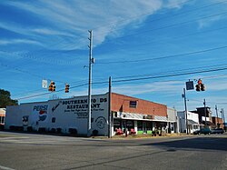
Brantley, Alabama.JPG
Brantley in 2012
Nickname: 
"Front Porch Capital of the South"
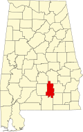
Crenshaw County Alabama Incorporated and Unincorporated areas Brantley Highlighted 0109016.svg
Location of Brantley in Crenshaw County, Alabama.
Coordinates: 31°35′3″N86°15′23″W / 31.58417°N 86.25639°W / 31.58417; -86.25639
CountryUnited States
State Alabama
County Crenshaw
Area
[1]
  Total3.16 sq mi (8.18 km2)
  Land3.11 sq mi (8.05 km2)
  Water0.05 sq mi (0.13 km2)
Elevation
295 ft (90 m)
Population
 (2020)
  Total825
  Density265.53/sq mi (102.52/km2)
Time zone UTC-6 (Central (CST))
  Summer (DST) UTC-5 (CDT)
ZIP code
36009
Area code 334
FIPS code 01-09016
GNIS feature ID0154995
Website www.townofbrantley.net

Brantley is a city in Crenshaw County, Alabama, United States. At the 2020 census, the population was 825. Brantley was incorporated in 1891 as a city.

Contents

Geography

Brantley is located in southern Crenshaw County at 31°35'4" North, 86°15'24" West (31.584365, −86.256651). [2]

According to the U.S. Census Bureau, the town has a total area of 3.16 square miles (8.18 km2), of which 3.11 square miles (8.05 km2) is land and 0.050 square miles (0.13 km2), or 1.60%, is water. [3] The town is located on high ground north of the Conecuh River.

Demographics

Historical population
CensusPop.Note
1900 390
1910 803105.9%
1920 702−12.6%
1930 1,05350.0%
1940 1,1266.9%
1950 1,102−2.1%
1960 1,014−8.0%
1970 1,0665.1%
1980 1,1518.0%
1990 1,015−11.8%
2000 920−9.4%
2010 809−12.1%
2020 8252.0%
U.S. Decennial Census [4]
2013 Estimate [5]

As of the census [6] of 2000, there were 920 people, 406 households, and 261 families residing in the town. The population density was 291.1 inhabitants per square mile (112.4/km2). There were 467 housing units at an average density of 147.8 per square mile (57.1/km2). The racial makeup of the town was 59.35% White, 40.22% Black or African American and 0.43% Native American. 0.11% of the population were Hispanic or Latino of any race.

There were 406 households, out of which 28.8% had children under the age of 18 living with them, 38.2% were married couples living together, 23.2% had a female householder with no husband present, and 35.5% were non-families. 34.5% of all households were made up of individuals, and 19.7% had someone living alone who was 65 years of age or older. The average household size was 2.27 and the average family size was 2.90.

In the town, the population was spread out, with 24.9% under the age of 18, 5.9% from 18 to 24, 27.0% from 25 to 44, 21.5% from 45 to 64, and 20.8% who were 65 years of age or older. The median age was 40 years. For every 100 females, there were 73.3 males. For every 100 females age 18 and over, there were 63.7 males.

The median income for a household in the town was $21,574, and the median income for a family was $30,078. Males had a median income of $26,063 versus $20,000 for females. The per capita income for the town was $14,108. About 18.8% of families and 24.6% of the population were below the poverty line, including 33.5% of those under age 18 and 25.6% of those age 65 or over.

Education

Brantley Public Schools are part of the Crenshaw County School District. Schools in the district include Luverne High School, Highland Home School and Brantley High School. Mr. Dodd Hawthorne is the superintendent . [7]

Confederate monument

In August 2017, a new Confederate monument was installed in the Confederate Veterans Memorial Park in Brantley. [8]

Climate

The climate in this area is characterized by hot, humid summers and generally mild to cool winters. According to the Köppen Climate Classification system, Brantley has a humid subtropical climate, abbreviated "Cfa" on climate maps. [9]

Climate data for Brantley, Alabama
MonthJanFebMarAprMayJunJulAugSepOctNovDecYear
Mean daily maximum °C (°F)14
(58)
17
(62)
21
(69)
26
(79)
29
(85)
33
(91)
34
(93)
33
(92)
31
(88)
26
(79)
21
(70)
17
(62)
25
(77)
Mean daily minimum °C (°F)0
(32)
2
(35)
5
(41)
10
(50)
14
(57)
18
(64)
20
(68)
19
(67)
17
(62)
9
(49)
4
(40)
1
(34)
10
(50)
Average precipitation cm (inches)13
(5)
13
(5.2)
16
(6.3)
12
(4.8)
10
(4.1)
11
(4.4)
15
(6)
14
(5.4)
11
(4.2)
5.8
(2.3)
8.9
(3.5)
12
(4.9)
142
(56.1)
Source: Weatherbase [10]

Notable residents

See also

Related Research Articles

<span class="mw-page-title-main">Crenshaw County, Alabama</span> County in Alabama, United States

Crenshaw County is a county located in the south central portion of the U.S. state of Alabama. It is located immediately south of the Montgomery metropolitan area. As of the 2020 census, the population was 13,194. Its county seat is Luverne. Its name is in honor of an Alabama judge, Anderson Crenshaw.

<span class="mw-page-title-main">Collinsville, Alabama</span> Town in Alabama, United States

Collinsville is a town in DeKalb and Cherokee counties in the U.S. state of Alabama. It was incorporated in 1887. As of the 2010 census, the population was 1,983.

<span class="mw-page-title-main">Opp, Alabama</span> City in Alabama, United States

Opp is a city in Covington County, Alabama, United States. At the 2020 census, the population was 6,771. Opp is named after Henry Opp, a lawyer for the Louisville and Nashville Railroad.

<span class="mw-page-title-main">Dozier, Alabama</span> Town in Alabama, United States

Dozier is a town in Crenshaw County, Alabama, United States. At the 2020 census, the population was 285. Dozier was incorporated in 1907.

<span class="mw-page-title-main">Glenwood, Alabama</span> Town in Alabama, United States

Glenwood is a town in Crenshaw County, Alabama, United States. At the 2020 census, the population was 152. Glenwood was incorporated in 1907.

<span class="mw-page-title-main">Luverne, Alabama</span> City in Alabama, United States

Luverne is a city in and the county seat of Crenshaw County, Alabama, United States. The city describes itself as "The Friendliest City in the South", a slogan that appears on its "welcome" signs. At the 2020 census, the population was 2,765.

<span class="mw-page-title-main">Petrey, Alabama</span> Town in Alabama, United States

Petrey is a town in Crenshaw County, Alabama, United States. The population was 58 at the 2010 census.

<span class="mw-page-title-main">Rutledge, Alabama</span> Town in Alabama, United States

Rutledge is a town in Crenshaw County, Alabama, United States. As of the 2010 census, the population of the town was 467.

<span class="mw-page-title-main">Clayhatchee, Alabama</span> Town in Alabama, United States

Clayhatchee is a town in Dale County, Alabama, United States. At the 2010 census the population was 589, up from 501 in 2000. It was incorporated in April 1967. It is part of the Ozark Micropolitan Statistical Area.

<span class="mw-page-title-main">Red Bay, Alabama</span> City in Alabama, United States

Red Bay is a city in Franklin County, Alabama, United States. It was founded in 1907; its western boundary line is integral with the state line between Mississippi and Alabama. The population was 3,232 at the 2020 census. The town's name comes from the area's red clay soil and the many redbay trees in this area of north Alabama.

<span class="mw-page-title-main">Greensboro, Alabama</span> City in Alabama, United States

Greensboro is a city in Hale County, Alabama, United States. At the 2010 census the population was 2,497, down from 2,731 at the 2000 census. The city is the county seat of Hale County, Alabama, which was not organized until 1867. It is part of the Tuscaloosa, Alabama Metropolitan Statistical Area.

<span class="mw-page-title-main">Goshen, Alabama</span> Town in Alabama, United States

Goshen is a town in Pike County, Alabama, United States. At the 2010 census the population was 266, down from 300 in 2000. It incorporated in 1907.

<span class="mw-page-title-main">Ashville, Alabama</span> City in and county seat of St. Clair County, Alabama

Ashville is a city in and one of the county seats of St. Clair County, Alabama, United States, other seat being Pell City. Its population was 2,212 at the 2010 census, down from 2,260, at which time it was a town. It incorporated in 1822.

<span class="mw-page-title-main">Bon Air, Alabama</span> Town in Alabama, United States

Bon Air is a town in Talladega County, Alabama, United States. It incorporated in 1932. At the 2010 census the population was 116, up from 96 in 2000.

<span class="mw-page-title-main">Brookwood, Alabama</span> City in Alabama, United States

Brookwood is a city in Tuscaloosa County, Alabama, United States. It incorporated in September 1977. As of the 2020 census, the population of the town is 2,504.

<span class="mw-page-title-main">Chatom, Alabama</span> City in and county seat of Washington County, Alabama

Chatom is a town in Washington County, Alabama, United States. It incorporated in 1949. Chatom is the county seat of Washington County, holding the distinction since 1907. The town's population was 1,288 At the 2010 census, up from 1,193 in 2000.

<span class="mw-page-title-main">Iuka, Mississippi</span> City in Mississippi, United States

Iuka is a city in and the county seat of Tishomingo County, Mississippi, United States. Its population was 3,028 at the 2010 census. Woodall Mountain, the highest point in Mississippi, is located just south of Iuka.

<span class="mw-page-title-main">Wartrace, Tennessee</span> Town in Tennessee, United States

Wartrace is a town in Bedford County, Tennessee. The population was 653 at the 2020 census. It is located northeast of Shelbyville. The downtown area is listed on the National Register of Historic Places as the Wartrace Historic District.

<span class="mw-page-title-main">Morristown, Vermont</span> Town in Vermont, United States

Morristown is a town in Lamoille County, Vermont, United States. As of the 2020 census, the population was 5,434. Morristown is the largest town by population in Lamoille County, and its central village of Morrisville serves as the county's main commercial center.

<span class="mw-page-title-main">New Market, Virginia</span> Town in Virginia, United States

New Market is a town in Shenandoah County, Virginia, United States. Founded as a small crossroads trading town in the Shenandoah Valley, it has a population of 2,155 as of the most recent 2020 U.S. census. The north–south U.S. 11 and the east–west U.S. 211 pass near it and cross Massanutten Mountain at the town's titular gap.

References

  1. "2020 U.S. Gazetteer Files". United States Census Bureau. Retrieved October 29, 2021.
  2. "US Gazetteer files: 2010, 2000, and 1990". United States Census Bureau. February 12, 2011. Retrieved April 23, 2011.
  3. "Geographic Identifiers: 2010 Demographic Profile Data (G001): Brantley city, Alabama". U.S. Census Bureau, American Factfinder. Archived from the original on February 12, 2020. Retrieved June 10, 2014.
  4. "U.S. Decennial Census". Census.gov. Retrieved June 6, 2013.
  5. "Annual Estimates of the Resident Population: April 1, 2010 to July 1, 2013". Archived from the original on May 22, 2014. Retrieved June 3, 2014.
  6. "U.S. Census website". United States Census Bureau . Retrieved January 31, 2008.
  7. "Crenshaw County Schools". Crenshaw County Schools. Retrieved June 20, 2012.
  8. Johnson, Alex (August 28, 2017). "A New Confederate Monument Goes Up in Alabama". NBC News. Retrieved August 29, 2017.
  9. Climate Summary for Brantley, Alabama
  10. "Weatherbase.com". Weatherbase. 2013. Retrieved on November 3, 2013.

31°35′04″N86°15′24″W / 31.584365°N 86.256651°W / 31.584365; -86.256651