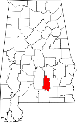
Crenshaw County | |
---|---|
Coordinates: 31°43′41″N86°18′36″W / 31.728055555556°N 86.31°W | |
Country | United States |
State | Alabama |
Founded | November 30, 1866 |
Named for | Anderson Crenshaw |
Seat | Luverne |
Largest city | Luverne |
Area | |
• Total | 611 sq mi (1,580 km2) |
• Land | 609 sq mi (1,580 km2) |
• Water | 2.1 sq mi (5 km2) 0.3% |
Population (2020) | |
• Total | 13,194 |
• Estimate (2023) | 13,101 |
• Density | 22/sq mi (8.3/km2) |
Time zone | UTC−6 (Central) |
• Summer (DST) | UTC−5 (CDT) |
Congressional district | 2nd |
Website | crenshawcountyalonline.com |
|
Crenshaw County is a county located in the south central portion of the U.S. state of Alabama. It is located immediately south of the Montgomery metropolitan area. As of the 2020 census, the population was 13,194. [1] Its county seat is Luverne. [2] Its name is in honor of an Alabama judge, Anderson Crenshaw.
Crenshaw County was established after the American Civil War on November 30, 1866, by the Reconstruction era legislature. It was formed from parts of Butler, Coffee, Covington, Pike and Lowndes counties. While part of the coastal area, this county had relatively infertile soils, limiting cotton and other agriculture. Its planters used enslaved African Americans for all needed types of labor. Many of their descendants stayed in the area, and nearly one-quarter of the county population is African American.
Crenshaw County became a center of timbering in the Piney Wood region, especially after the Montgomery and Florida Railroad Company constructed a line through the county in 1886. This provided transport to markets for timber. It connected with Sprague Junction in Montgomery County, Alabama. The timber camps were rough work areas where racial tensions sometimes flared.
According to the United States Census Bureau, the county has a total area of 611 square miles (1,580 km2), of which 609 square miles (1,580 km2) is land and 2.1 square miles (5.4 km2) (0.3%) is water. [3] The county is located in the Gulf Coastal Plain region of the state. Much of the land is also covered by forests that are used for logging.
Census | Pop. | Note | %± |
---|---|---|---|
1870 | 11,156 | — | |
1880 | 11,726 | 5.1% | |
1890 | 15,425 | 31.5% | |
1900 | 19,668 | 27.5% | |
1910 | 23,313 | 18.5% | |
1920 | 23,017 | −1.3% | |
1930 | 23,656 | 2.8% | |
1940 | 23,631 | −0.1% | |
1950 | 18,981 | −19.7% | |
1960 | 14,909 | −21.5% | |
1970 | 13,188 | −11.5% | |
1980 | 14,110 | 7.0% | |
1990 | 13,635 | −3.4% | |
2000 | 13,665 | 0.2% | |
2010 | 13,906 | 1.8% | |
2020 | 13,194 | −5.1% | |
2023 (est.) | 13,101 | [4] | −0.7% |
U.S. Decennial Census [5] 1790–1960 [6] 1900–1990 [7] 1990–2000 [8] 2010–2020 [1] |
Race / Ethnicity (NH = Non-Hispanic) | Pop 2000 [9] | Pop 2010 [10] | Pop 2020 [11] | % 2000 | % 2010 | % 2020 |
---|---|---|---|---|---|---|
White alone (NH) | 10,042 | 10,020 | 9,333 | 73.49% | 72.06% | 70.74% |
Black or African American alone (NH) | 3,369 | 3,241 | 3,085 | 24.65% | 23.31% | 23.38% |
Native American or Alaska Native alone (NH) | 51 | 56 | 48 | 0.37% | 0.40% | 0.36% |
Asian alone (NH) | 15 | 189 | 83 | 0.11% | 1.36% | 0.63% |
Pacific Islander alone (NH) | 1 | 1 | 2 | 0.01% | 0.01% | 0.02% |
Other race alone (NH) | 11 | 2 | 27 | 0.08% | 0.01% | 0.20% |
Mixed race or Multiracial (NH) | 89 | 193 | 429 | 0.65% | 1.39% | 3.25% |
Hispanic or Latino (any race) | 87 | 204 | 187 | 0.64% | 1.47% | 1.42% |
Total | 13,665 | 13,906 | 13,194 | 100.00% | 100.00% | 100.00% |
As of the 2020 United States census, there were 13,194 people, 4,943 households, and 3,384 families residing in the county.
As of the census [12] of 2010, there were 13,906 people, 5,652 households, and 3,882 families living in the county. The population density was 23 people per square mile (8.9 people/km2). There were 6,735 housing units at an average density of 11 units per square mile (4.2 units/km2). The racial makeup of the county was 72.6% White, 23.4% Black or African American, 0.4% Native American, 1.4% Asian, 0.1% Pacific Islander, 0.7% from other races, and 1.5% from two or more races. 1.5% of the population were Hispanic or Latino of any race.
There were 5,652 households, out of which 27.3% had children under the age of 18 living with them, 48.7% were married couples living together, 15.6% had a female householder with no husband present, and 31.3% were non-families. 28.1% of all households were made up of individuals, and 11.9% had someone living alone who was 65 years of age or older. The average household size was 2.44 and the average family size was 2.97.
In the county, the population was spread out, with 23.8% under the age of 18, 8.0% from 18 to 24, 23.6% from 25 to 44, 28.7% from 45 to 64, and 15.9% who were 65 years of age or older. The median age was 40.7 years. For every 100 females there were 93.4 males. For every 100 females age 18 and over, there were 95.3 males.
The median income for a household in the county was $35,140, and the median income for a family was $47,685. Males had a median income of $35,598 versus $22,410 for females. The per capita income for the county was $19,793. About 13.7% of families and 17.7% of the population were below the poverty line, including 25.5% of those under age 18 and 16.7% of those age 65 or over.
The largest self-reported ancestry groups in Crenshaw County were English (64.5%), German (12.1%), Irish (11.2%), Italian (3.9%), "American" (3.1%), Scottish (2.9%) and Portuguese (1.8%).
As of the census [13] of 2000, there were 13,665 people, 5,577 households, and 3,892 families living in the county. The population density was 22 people per square mile (8.5 people/km2). There were 6,644 housing units at an average density of 11 units per square mile (4.2 units/km2). The racial makeup of the county was 73.82% White, 24.79% Black or African American, 0.37% Native American, 0.11% Asian, 0.01% Pacific Islander, 0.20% from other races, and 0.70% from two or more races. 0.64% of the population were Hispanic or Latino of any race.
There were 5,577 households, out of which 31.00% had children under the age of 18 living with them, 50.70% were married couples living together, 15.40% had a female householder with no husband present, and 30.20% were non-families. 28.20% of all households were made up of individuals, and 14.70% had someone living alone who was 65 years of age or older. The average household size was 2.42 and the average family size was 2.96.
In the county, the population was spread out, with 24.70% under the age of 18, 7.90% from 18 to 24, 26.30% from 25 to 44, 23.90% from 45 to 64, and 17.10% who were 65 years of age or older. The median age was 39 years. For every 100 females there were 89.80 males. For every 100 females age 18 and over, there were 83.60 males.
The median income for a household in the county was $26,054, and the median income for a family was $31,724. Males had a median income of $27,286 versus $17,703 for females. The per capita income for the county was $14,565. About 18.60% of families and 22.10% of the population were below the poverty line, including 28.30% of those under age 18 and 23.50% of those age 65 or over.
Crenshaw County is reliably Republican at the presidential level. The last Democrat to win the county in a presidential election is Bill Clinton, who won it by a plurality in 1996.
Year | Republican | Democratic | Third party(ies) | |||
---|---|---|---|---|---|---|
No. | % | No. | % | No. | % | |
2020 | 4,864 | 73.51% | 1,700 | 25.69% | 53 | 0.80% |
2016 | 4,513 | 72.01% | 1,664 | 26.55% | 90 | 1.44% |
2012 | 4,331 | 67.42% | 2,050 | 31.91% | 43 | 0.67% |
2008 | 4,319 | 68.65% | 1,938 | 30.81% | 34 | 0.54% |
2004 | 3,777 | 68.67% | 1,698 | 30.87% | 25 | 0.45% |
2000 | 2,793 | 58.25% | 1,934 | 40.33% | 68 | 1.42% |
1996 | 1,939 | 43.60% | 2,172 | 48.84% | 336 | 7.56% |
1992 | 2,339 | 44.22% | 2,404 | 45.44% | 547 | 10.34% |
1988 | 2,617 | 58.44% | 1,836 | 41.00% | 25 | 0.56% |
1984 | 3,261 | 61.86% | 1,904 | 36.12% | 107 | 2.03% |
1980 | 2,478 | 47.15% | 2,704 | 51.45% | 74 | 1.41% |
1976 | 1,801 | 34.20% | 3,372 | 64.03% | 93 | 1.77% |
1972 | 3,129 | 72.87% | 1,085 | 25.27% | 80 | 1.86% |
1968 | 209 | 3.81% | 726 | 13.25% | 4,545 | 82.94% |
1964 | 3,008 | 78.66% | 0 | 0.00% | 816 | 21.34% |
1960 | 573 | 16.37% | 2,923 | 83.49% | 5 | 0.14% |
1956 | 567 | 19.06% | 2,252 | 75.70% | 156 | 5.24% |
1952 | 544 | 17.94% | 2,485 | 81.96% | 3 | 0.10% |
1948 | 38 | 2.65% | 0 | 0.00% | 1,394 | 97.35% |
1944 | 118 | 5.61% | 1,980 | 94.06% | 7 | 0.33% |
1940 | 84 | 3.03% | 2,680 | 96.65% | 9 | 0.32% |
1936 | 96 | 3.89% | 2,371 | 95.95% | 4 | 0.16% |
1932 | 127 | 5.32% | 2,200 | 92.13% | 61 | 2.55% |
1928 | 978 | 42.67% | 1,314 | 57.33% | 0 | 0.00% |
1924 | 117 | 9.41% | 1,107 | 89.06% | 19 | 1.53% |
1920 | 310 | 17.93% | 1,411 | 81.61% | 8 | 0.46% |
1916 | 139 | 8.81% | 1,427 | 90.43% | 12 | 0.76% |
1912 | 47 | 4.03% | 986 | 84.49% | 134 | 11.48% |
1908 | 311 | 20.94% | 1,100 | 74.07% | 74 | 4.98% |
1904 | 180 | 13.25% | 1,077 | 79.25% | 102 | 7.51% |
Montgomery County is a county located in the U.S. state of Alabama. As of the 2020 census, its population was 228,954, making it the seventh-most populous county in Alabama. Its county seat is Montgomery, the state capital. Montgomery County is included in the Montgomery Metropolitan Statistical Area.
Chambers County is a county located in the east central portion of the U.S. state of Alabama. As of the 2020 census the population was 34,772. Its county seat is LaFayette. Its largest city is Valley. Its name is in honor of Henry H. Chambers, who served as a United States Senator from Alabama.
Etowah County is a county located in the northeastern part of the U.S. state of Alabama. As of the 2020 census the population was 103,436. Its county seat is Gadsden. Its name is from a Cherokee word meaning "edible tree". In total area, it is the smallest county in Alabama, albeit one of the most densely populated. Etowah County comprises the Gadsden Metropolitan Statistical Area.
Morgan County is a county in the north-central part of the U.S. state of Alabama. As of the 2020 census, its population was 123,421. The county seat is Decatur. On June 14, 1821, it was renamed in honor of American Revolutionary War General Daniel Morgan of Virginia. It is a prohibition or dry county, although alcohol sales are allowed in the cities of Decatur, Hartselle, and Priceville. Morgan County is included in the Decatur, AL Metropolitan Statistical Area, which is also included in the Huntsville-Decatur-Albertville, AL Combined Statistical Area. It is a part of the North, Northwest, and North-Central regions of Alabama.
Coffee County is a county located in the southeastern part of the U.S. state of Alabama. As of the 2020 census, the population was 53,465. Its name is in honor of General John Coffee.
Coosa County is a county located in the east central portion of the U.S. state of Alabama. As of the 2020 census the population was 10,387. Its county seat is Rockford. Its name derives from a town of the Creek tribe and the Coosa River, which forms one of the county borders.
Covington County is a county located in the south central portion of the U.S. state of Alabama. As of the 2020 census the population was 37,570. Its county seat is Andalusia. Its name is in honor of Brigadier General Leonard Covington of Maryland and Mississippi, who died in the War of 1812.
Franklin County is a county located in the U.S. state of Alabama. As of the 2020 census, the population was 32,113. Its county seat is Russellville. Its name is in honor of Benjamin Franklin, famous statesman, scientist, and printer. It is a dry county, although the city of Russellville is wet.
Houston County is a county located in the southeastern corner of the U.S. state of Alabama. As of the 2020 census the population was 107,202. Its county seat is Dothan, which is located on the border and partially in adjacent Henry County.
Pike County is a county located in the U.S. state of Alabama. As of the 2020 census the population was 33,009. Its county seat is Troy. Its name is in honor of General Zebulon Pike, of New Jersey, who led an expedition to southern Colorado and encountered Pikes Peak in 1806.
Randolph County is a county on the central eastern border of the U.S. state of Alabama. As of the 2020 census, the population was 21,967. Its county seat is Wedowee. Its name is in honor of John Randolph, a member of the United States Senate from Virginia. Randolph County was a prohibition or dry county until 2012, when the citizens of Randolph County voted to repeal prohibition.
Tallapoosa County is a county located in the east-central portion of the U.S. state of Alabama. As of the 2020 census, the population was 41,311. Its county seat is Dadeville. Its largest city is Alexander City.
Walker County is a county located in the central portion of the U.S. state of Alabama. As of the 2020 census, the population was 65,342. Its county seat is Jasper. Its name is in honor of John Williams Walker, the first U.S. senator elected from Alabama.
Glenwood is a town in Crenshaw County, Alabama, United States. At the 2020 census, the population was 152. Glenwood was incorporated in 1907.
Luverne is a city in and the county seat of Crenshaw County, Alabama, United States. The city describes itself as "The Friendliest City in the South", a slogan that appears on its "welcome" signs. At the 2020 census, the population was 2,765.
Elmore is a town in Elmore County, Alabama, United States. Although initially incorporated in 1906, it lapsed and was not reincorporated again until 1997. At the 2010 census the population was 1,262, up from 199 in 2000. It is part of the Montgomery Metropolitan Statistical Area.
Rock Creek is a census-designated place in Jefferson County, Alabama, United States. Its location is northwest of Hueytown. At the 2020 census, the population was 1,471. This area was damaged by an F5 tornado on April 8, 1998. An EF2 tornado struck northwest from here on January 23, 2012.
Gordonville is a town in Lowndes County, Alabama, United States. At the 2010 census the population was 326, up from 318 in 2000. It is part of the Montgomery Metropolitan Statistical Area. It incorporated effective January 20, 1990.
White Hall is a town in Lowndes County, Alabama, United States. The community was named for a plantation that was destroyed in an 1882 tornado. At the 2010 census the population was 858, down from its record high of 1,014 in 2000. It is part of the Montgomery Metropolitan Statistical Area.
Shorter is a town in Macon County, Alabama, United States. At the 2020 census the population was 385, down from 474 at the 2010 census. According to the 1990 U.S. Census records, it was incorporated in 1984.