List of metropolitan areas of Alabama

Last updated

Birmingham, largest metropolitan area Birmingham panorama.jpg
Birmingham, largest metropolitan area
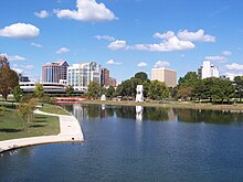
Huntsville, largest city and second largest metropolitan area Downtown Huntsville, Alabama.jpg
Huntsville, largest city and second largest metropolitan area
Mobile, third largest metropolitan area Mobile Skyline.jpg
Mobile, third largest metropolitan area

The following is a list of the largest metropolitan areas in Alabama. [1] As of 2020 Birmingham has the biggest metropolitan area and urban area in Alabama followed by Huntsville. The table data is from the Us Census in 2010 and 2020. [2] [3]

RankMetropolitan AreaPopulation
(2020 Census)
Population
(2010 Census)
1 Birmingham 1,091,9211,061,024
2 Huntsville 481,681417,593
3 Mobile 428,692430,573
4 Montgomery 372,583374,536
5 Tuscaloosa 253,211239,207
6 Daphne-Fairhope-Foley 229,287182,265
7 Auburn 166,831140,247
8 Decatur 152,740152,829
9 Dothan 150,214145,639
10 Florence-Muscle Shoals 148,779147,137
11 Anniston-Oxford 113,469118,572
12 Gadsden 102,371104,430
RankCombined Statistical areaPopulation
(2016 Estimate)
Population
(2010 Census)
1 Birmingham-Hoover-Talladega 1,361,2991,302,283
2 Huntsville-Decatur-Albertville 768,033664,441
3 Mobile-Daphne-Fairhope 623,399595,257
4 Pensacola-Ferry Pass 523,412487,310
5 Columbus-Auburn-Opelika 501,589469,327
6 Dothan-Enterprise-Ozark 248,286245,838

See also

Related Research Articles

In the United States, a metropolitan statistical area (MSA) is a geographical region with a relatively high population density at its core and close economic ties throughout the region. Such regions are not legally incorporated as a city or town would be and are not legal administrative divisions like counties or separate entities such as states. As a result, sometimes the precise definition of a given metropolitan area will vary between sources. The statistical criteria for a standard metropolitan area were defined in 1949 and redefined as a metropolitan statistical area in 1983.

<span class="mw-page-title-main">Coffee County, Alabama</span> County in Alabama, United States

Coffee County is a county located in the southeastern part of the U.S. state of Alabama. As of the 2020 census, the population was 53,465. Its name is in honor of General John Coffee.

<span class="mw-page-title-main">Ozark, Alabama</span> City in Alabama, United States

Ozark is a city in and the county seat of Dale County, Alabama. As of the 2010 census, the population of the city was 14,907.

<span class="mw-page-title-main">Micropolitan statistical area</span> Statistical area of the United States

United States micropolitan statistical areas, as defined by the Office of Management and Budget (OMB), are labor market and statistical areas in the United States centered on an urban cluster with a population of at least 10,000 but fewer than 50,000 people. The micropolitan area designation was created in 2003. Like the better-known metropolitan statistical areas, a micropolitan area is a geographic entity used for statistical purposes based on counties and county equivalents. On July 21, 2023, the Office of Management and Budget released revised delineations of the various CBSAs in the United States, which recognized 542 micropolitan areas in the United States, four of which are in Puerto Rico.

<span class="mw-page-title-main">Mobile metropolitan area</span> Metropolitan Statistical Area in Alabama, United States

The Mobile Metropolitan Area comprises Mobile in the southwest corner of Alabama in the United States. As of the 2020 census the metropolitan area had a population of 430,197. The Mobile metropolitan area is the third-largest metropolitan area in the state of Alabama, after Birmingham and Huntsville. Washington County was part of the Mobile metropolitan area but was removed when the OMB released its statistical definitions effective July 2023.

<span class="mw-page-title-main">Auburn metropolitan area, Alabama</span> Metropolitan Statistical Area in Alabama, United States

The Auburn Metropolitan Area—officially the Auburn-Opelika, Alabama Metropolitan Statistical Area—is a metro area in east-central Alabama with a 2016 population of 158,991. It was the 19th fastest growing metro area in the United States between 1990 and 2000. The Auburn Metro area consists of Lee County, and includes the cities of Auburn, Opelika, and the northernmost portion of Phenix City.

<span class="mw-page-title-main">Huntsville–Decatur combined statistical area</span> Combined Statistical Area in the United States

The Huntsville–Decatur–Albertville, Alabama, combined statistical area is the most populated sub-region of North Alabama, and is the second largest combined statistical area in the State of Alabama after Birmingham. The Huntsville-Decatur-Albertville CSA had a total of 879,315 people in 2022 and ranks 68th in the country.

<span class="mw-page-title-main">Baton Rouge metropolitan area</span> Metropolitan Statistical Area in Louisiana, United States

The Baton Rouge metropolitan statistical area, as defined by the United States Office of Management and Budget, or simply the Baton Rouge metropolitan area or Greater Baton Rouge, is a sprawling metropolitan statistical area surrounding the city of Baton Rouge. Including the western edge of the Florida Parishes regions, it is known as "Plantation Country", the "Capital Region", and "The 225". At the 2010 U.S. census, the metropolitan area had a population of 802,484, up from 705,973 in 2000. At the 2020 census, its population increased to 870,569, up from 2020 estimates at 858,571.

The U.S. State of Alabama currently has 34 statistical areas that have been delineated by the Office of Management and Budget (OMB).

<span class="mw-page-title-main">Buffalo–Niagara Falls metropolitan area</span> Metropolitan statistical area in New York, United States

The Buffalo–Niagara Falls Metropolitan statistical area is a metropolitan area, designated by the United States Census Bureau, encompassing two counties - Erie and Niagara - in the state of New York. It has a population of over 1.1 million people and is the second-largest metropolitan area in the state. As of the 2020 U S. census, the metropolitan statistical area (MSA) had a population of 1,166,902. The larger Buffalo Niagara Region is an economic zone consisting of eight counties in Western New York.

<span class="mw-page-title-main">Knoxville metropolitan area</span> Metropolitan area in Tennessee, United States

The Knoxville metropolitan area, commonly known as Greater Knoxville, is a metropolitan statistical area (MSA) centered on Knoxville, Tennessee, the third largest city in Tennessee and the largest city in East Tennessee. It is the third largest metropolitan area in Tennessee. In 2020, the Knoxville metro area had a population of 879,773, and a population of 903,300 including Grainger County. The Knoxville–Morristown–Sevierville Combined Statistical Area (CSA) had a population of 1,156,861 according to the census bureau in 2020.

<span class="mw-page-title-main">Chattanooga metropolitan area</span> Metropolitan area in Tennessee and Georgia, United States

The Chattanooga, TN-GA metropolitan statistical area, as defined by the United States Office of Management and Budget, is an area consisting of six counties – three in southeast Tennessee and three in northwest Georgia – anchored by the city of Chattanooga. As of the 2020 census, the Chattanooga metropolitan area had a population of 562,647. This metropolitan area traverses two time zones.

<span class="mw-page-title-main">Montgomery metropolitan area</span> Metropolitan Statistical Area in Alabama, United States

The Montgomery, Alabama Metropolitan Statistical Area is a metropolitan area in central Alabama. As of 2020, the MSA had a population of 386,047, ranking it 142nd among United States Metropolitan Statistical Areas. That number is up +3.07% from the 2010 census number of 374,536.

<span class="mw-page-title-main">Dothan metropolitan area, Alabama</span> Metropolitan Statistical Area in Alabama, United States

The Dothan Metropolitan Statistical Area, as defined by the United States Census Bureau, is an area consisting of Geneva, Henry, and Houston counties in southeastern Alabama, anchored by the city of Dothan, county seat of Houston County. As of the 2010 census, the MSA had a population of 145,639.

<span class="mw-page-title-main">Columbus metropolitan area, Georgia</span> Combined Statistical Area in the United States

The Columbus metropolitan area, officially the Columbus metropolitan statistical area, and colloquially known as the Chattahoochee Valley, is a metropolitan statistical area consisting of six counties in the U.S. state of Georgia and one county in Alabama, anchored by the city of Columbus.

<span class="mw-page-title-main">Huntsville metropolitan area</span> Metropolitan statistical area in Alabama, US

The Huntsville Metropolitan Statistical Area is a metropolitan statistical area on the northern border of Alabama. The metro area's principal city is Huntsville, and consists of two counties: Limestone and Madison. As of the 2020 United States census, the Huntsville Metropolitan Area's population was 491,723, making it the 2nd-largest metropolitan area in Alabama and the 113th-largest in the United States.

<span class="mw-page-title-main">Columbus–Auburn–Opelika combined statistical area</span> Combined Statistical Area in the United States

The Columbus–Auburn–Opelika, GA–AL Combined Statistical Area is a trading and marketing area made up of six counties in Georgia and two in Alabama. The statistical area includes two metropolitan areas: the Columbus metropolitan area and the Auburn–Opelika metropolitan area. As of 2021, the CSA had a population of 503,709.

<span class="mw-page-title-main">Birmingham metropolitan area, Alabama</span> Metropolitan Statistical Area in Alabama, United States

The Birmingham metropolitan area, sometimes known as Greater Birmingham, is a metropolitan area in north central Alabama centered on Birmingham, Alabama, United States.

Dixonville is an unincorporated community and census-designated place in Santa Rosa County, Florida, United States. Its population was 195 at the 2020 census, up from 181 at the 2010 census. It is part of the Pensacola—Ferry Pass—Brent, Florida Metropolitan Statistical Area. Florida State Road 87 passes through the community. The community name continues north of the state line in Alabama along Alabama State Route 41.

References

  1. "Alabama metro area chart". Al.com. 3 December 2021.
  2. "2010 Census Data" (PDF).
  3. "Census data 2020".