Madison County, Alabama

Last updated

Madison County
Madison County Courthouse May 2011 02.jpg
Madison County Courthouse in Huntsville
Map of Alabama highlighting Madison County.svg
Location within the U.S. state of Alabama
Alabama in United States.svg
Alabama's location within the U.S.
Coordinates: 34°45′57″N86°33′28″W / 34.765833333333°N 86.557777777778°W / 34.765833333333; -86.557777777778
CountryFlag of the United States.svg United States
StateFlag of Alabama.svg  Alabama
FoundedDecember 13, 1808 [1]
Named for James Madison
Seat Huntsville
Largest cityHuntsville
Government
  Commission Chairman Mac McCutcheon [2]
Area
  Total813 sq mi (2,110 km2)
  Land802 sq mi (2,080 km2)
  Water11 sq mi (30 km2)  1.4%
Population
 (2020)
  Total388,153
  Estimate 
(2023)
412,600 Increase2.svg
  Density480/sq mi (180/km2)
Time zone UTC−6 (Central)
  Summer (DST) UTC−5 (CDT)
Congressional district 5th
Website www.madisoncountyal.gov
 
  • County Number 47 on Alabama License Plates
  • Largest County by population not shuffled to top 2 on Alabama License Plates

Madison County is located in the north central portion of the U.S. state of Alabama. As of the 2020 Census, the population was 388,153, making it the second-most populous county in Alabama. [3] Its county seat is Huntsville. [4] Since the mid-20th century it has become an area of defense and space research and industry.

Contents

The county is named in honor of James Madison, [5] fourth President of the United States and the first President to visit the state of Alabama. Madison County covers parts of the former Decatur County. Madison County is included in the Huntsville, Alabama Metropolitan Statistical Area.

History

Madison County was established on December 13, 1808, by the governor of the Mississippi Territory. [1] It is recognized as the "birthplace" of the state of Alabama, which was admitted to the Union on December 14, 1819. Huntsville was designated as the first capital of the new state.

For much of the county's history, its economy was based on agriculture, particularly cotton plantations, which were established across the uplands. These plantations and their owners' profits were dependent on the labor of enslaved African Americans before the Civil War. Madison County was one of the largest cotton-producing counties in the state.

Madison County was the largest county in Alabama in population from 1810 to 1840. [6] [7] In the 1810 census alone, Madison County made up nearly half of the population in what would become Alabama, though this did not include Native American tribes and their people. By 1850 however it would lose the title and be the 7th due to its population growth having slowed down. The likely reason was due to Madison county having mainly relied on cotton with little to no other industries. [8]

Cotton remained important after the war. Most labor for cultivation was still provided by African Americans, but they worked as sharecroppers and tenant farmers. By the late 19th century, textile mills had been established around the county; they were restricted to white workers by the Jim Crow practices of racial segregation. During the early 20th century, the economy continued to be largely agricultural, although textile mills expanded their production.

During World War II, the Army established Redstone Arsenal here as a chemical weapon manufacturing site, and the county attracted related industries. After the war, it became a center of new weapon and rocket development. In 1950, a group of exiled German rocket scientists, led by Wernher von Braun, came to Redstone Arsenal from Fort Bliss, Texas in order to conduct research and development of new types of rockets.

By the 1960s, research expanded to rockets for space exploration. The Redstone rocket was modified to launch the first two Americans into space. The US began to emphasize investment in the Space Race, in order to compete with the Soviet Union during the Cold War years and to increase scientific gains. This work in the defense and space industries has generated tens of thousands of jobs in the area, most of them private contractors working in these fields. The population of Madison County has risen from 72,903 in 1950 to an estimated 403,565 in 2022.

Geography

According to the United States Census Bureau, the county has a total area of 813 square miles (2,110 km2), of which 802 square miles (2,080 km2) is land and 11 square miles (28 km2) (1.4%) is water. [9]

The topography in the southern and eastern portions of the county is dominated by the dissected remnants of the Cumberland Plateau, such as Keel Mountain, Monte Sano Mountain and Green Mountain. The northern and western portions of the county are flatter.

Rivers

Adjacent counties

Farm fields near New Market Madison-County-fields-al1.jpg
Farm fields near New Market

National protected area

Demographics

Historical population
CensusPop.Note
1810 4,699
1820 17,481272.0%
1830 27,99060.1%
1840 25,706−8.2%
1850 26,4272.8%
1860 26,4510.1%
1870 31,26718.2%
1880 37,62520.3%
1890 38,1191.3%
1900 43,70214.6%
1910 47,0417.6%
1920 51,2689.0%
1930 64,62326.0%
1940 66,3172.6%
1950 72,9039.9%
1960 117,34861.0%
1970 186,54059.0%
1980 196,9665.6%
1990 238,91221.3%
2000 276,70015.8%
2010 334,81121.0%
2020 388,15315.9%
2023 (est.)412,600 [10] 6.3%
U.S. Decennial Census [11]
1790–1960 [12] 1900–1990 [13]
1990–2000 [14] 2010–2020 [3]

2020 census

Madison County, Alabama – Racial and Ethnic Composition
(NH = Non-Hispanic)
Note: the US Census treats Hispanic/Latino as an ethnic category. This table excludes Latinos from the racial categories and assigns them to a separate category. Hispanics/Latinos may be of any race.
Race / EthnicityPop 2000 [15] Pop 2010 [16] Pop 2020 [17] % 2000% 2010% 2020
White alone (NH)196,496221,445237,49771.01%66.14%61.19%
Black or African American alone (NH)62,60279,51791,07922.62%23.75%23.46%
Native American or Alaska Native alone (NH)2,0672,3352,1320.75%0.70%0.55%
Asian alone (NH)5,1078,16710,1791.85%2.44%2.62%
Pacific Islander alone (NH)1403214500.05%0.10%0.12%
Some Other Race alone (NH)3004711,7020.11%0.14%0.44%
Mixed Race or Multi-Racial (NH)4,7627,15120,1781.72%2.14%5.20%
Hispanic or Latino (any race)5,22615,40424,9361.89%4.60%6.42%
Total276,700334,811388,153100.00%100.00%100.00%

As of the 2020 census, there were 388,153 people, 157,770 households, and 101,684 families residing in the county. [18] The population density was 484.2 inhabitants per square mile (187.0/km2) There were 169,820 housing units.

2010

As of the 2010 census, there were 334,811 people, 109,955 households, out of which 33.00% had children under the age of 18 living with them; 53.40% were married couples living together, 11.80% had a female householder with no husband present, and 31.50% were non-families. Nearly 27.20% of all households were made up of individuals, and 7.40% had someone living alone who was 65 years of age or older. The average household size was 2.45, and the average family size was 3.00.

In the county, the population was spread out, with 25.60% under the age of 18, 9.40% from 18 to 24, 31.50% from 25 to 44, 22.70% from 45 to 64, and 10.80% who were 65 years of age or older. The median age was 36 years. For every 100 females, there were 95.30 males. For every 100 females age 18 and over, there were 92.10 males.

The median income for a household in the county was $44,704, and the median income for a family was $54,360. Males had a median income of $40,779 versus $26,534 for females. The per capita income for the county was $23,091. About 8.10% of families and 10.50% of the population were below the poverty line, including 14.10% of those under age 18 and 9.60% of those age 65 or over.

2000

As of the 2000 census, there were 276,700 people, 109,955 households, and 75,319 families residing in the county. The population density was 344 people per square mile (133 people/km2). There were 120,288 housing units at an average density of 149 units per square mile (58 units/km2). The racial makeup of the county was 72.06% White, 22.78% Black or African American, 0.77% Native American, 1.86% Asian, 0.06% Pacific Islander, 0.59% from other races, and 1.89% from two or more races. Nearly 1.91% of the population were Hispanic or Latino of any race.

According to the 2000 census, the largest ancestry groups in Madison County were English 50.2%, African 22.78%, Scots-Irish 8.71%, Irish 4.3%, Scottish 4.12%, and Welsh 2.9%.

Communities

Cities

Towns

Census-designated places

Unincorporated communities

Education

The Madison County School System runs public schools throughout the unincorporated areas of the county and the incorporated and unincorporated communities of: Gurley, Harvest, Hazel Green, Meridianville, Moores Mill, New Hope, Owens Cross Roads, New Market, Redstone Arsenal, Triana. It also includes a few parcels of Huntsville. [19] The system also includes Toney and Monrovia.[ citation needed ] The system runs 14 elementary schools, 4 middle schools, 5 high schools and a ninth grade school, and a career/technical center.

High schools in the Madison County School System are:

There are a number of private schools serving Madison County. These include Randolph School, Madison Academy, Westminster Christian Academy, Faith Christian Academy, and several others.

Madison City and the vast majority of Huntsville both have their own separate school systems (Madison City School District and Huntsville City School District). [19]

Transportation

Major highways

Transit

Rail

Air travel

The Port of Huntsville provides both passenger air service, via Huntsville International Airport which allows access to most of the rest of the United States, and shipping air service, via the International Intermodal Center. There are also three smaller public airports in the county: Hazel Green Airport, Madison County Executive Airport, and Moontown Airport.

Bicycle routes

There are several bicycle routes in the city of Huntsville. Madison County has a master plan to develop a 70-mile bicycle and walking trail.[ citation needed ]

Politics

Madison County was formerly an overwhelmingly Democratic county as with most of the rest of Alabama, with only a narrow loss by Al Smith in 1928 due to Prohibitionist anti-Catholicism [20] disrupting this trend until the 1960s. Even in 1964, the county nearly voted against Barry Goldwater due to its opposition to the Arizona Senator’s privatization plans for the Tennessee Valley Authority. However, since that time, the county has become solidly Republican, with the only national Democratic nominee to carry the county since 1960 being Deep South native Jimmy Carter in 1976. In the 2016 election, Gary Johnson had his best showing in the state, carrying 4.05 percent of the vote. The county is trending less Republican recently, 58.9% in 2004, 56.9% in 2008, 54.8% in 2016, and in 2020 the Republican margin of victory was the lowest since 1980. For Alabama counties supporting Donald Trump in 2016, it was the fourth narrowest margin, and in 2020 the third-narrowest after Conecuh and Barbour.

The governing body of the county is a commission. The commission is responsible for levying the county tax, establish, maintain, and discontinue county roads and bridges. The commission is also responsible for the county jail as well as the sheriff's department. The County Commission is composed of seven members. A Chairman is elected at-large by the county while each of the other six members is elected by their districts. Each commissioner serves a four-year term. [21] In 2020, Violet Edwards made history becoming the first black woman to be elected to the Madison County Commission. [22]

United States presidential election results for Madison County, Alabama [23]
Year Republican Democratic Third party
No.%No.%No.%
2020 102,78052.77%87,28644.82%4,7012.41%
2016 89,52054.79%62,82238.45%11,0476.76%
2012 90,88458.47%62,01539.90%2,5291.63%
2008 86,96556.88%64,11741.93%1,8171.19%
2004 77,17358.88%52,64440.17%1,2450.95%
2000 62,15154.85%48,19942.53%2,9682.62%
1996 50,39049.96%42,25941.90%8,2098.14%
1992 51,44447.71%38,97436.14%17,41616.15%
1988 53,57567.06%25,80032.29%5190.65%
1984 50,42864.54%26,88134.40%8251.06%
1980 30,60447.03%30,46946.82%3,9996.15%
1976 20,95936.59%35,49761.96%8311.45%
1972 38,89973.42%13,10824.74%9771.84%
1968 13,21325.43%8,00415.41%30,73659.16%
1964 14,27951.93%00.00%13,21748.07%
1960 5,29932.34%10,95966.88%1280.78%
1956 2,99324.63%9,05474.52%1030.85%
1952 1,62316.36%8,21682.82%810.82%
1948 46613.22%00.00%3,06086.78%
1944 4558.39%4,95191.33%150.28%
1940 5669.28%5,51590.44%170.28%
1936 5148.26%5,66191.01%450.72%
1932 55910.35%4,79288.76%480.89%
1928 2,69550.11%2,68149.85%20.04%
1924 36814.23%2,16683.76%522.01%
1920 48914.64%2,82284.49%290.87%
1916 2158.69%2,20689.17%532.14%
1912 1505.47%2,14678.21%44816.33%
1908 27711.13%2,16887.10%441.77%
1904 1827.87%2,11991.61%120.52%
1900 1,67931.27%3,64167.80%500.93%
1896 2,54837.73%4,05660.06%1492.21%
1892 30.05%3,04645.72%3,61454.24%
1888 2,59554.77%2,13645.08%70.15%

Places of interest

Madison County is home to Monte Sano State Park, the U.S. Space & Rocket Center, and part of the Flint River. It also contains Hampton Cove Golf Course, part of the Robert Trent Jones Golf Trail. There is a historical marker for Lincoln School and Village which were incorporated into Huntsville in 1956. [24]

See also

Related Research Articles

<span class="mw-page-title-main">Morgan County, Alabama</span> County in Alabama, United States

Morgan County is a county in the north-central part of the U.S. state of Alabama. As of the 2020 census, its population was 123,421. The county seat is Decatur. On June 14, 1821, it was renamed in honor of American Revolutionary War General Daniel Morgan of Virginia. It is a prohibition or dry county, although alcohol sales are allowed in the cities of Decatur, Hartselle, and Priceville. Morgan County is included in the Decatur, AL Metropolitan Statistical Area, which is also included in the Huntsville-Decatur-Albertville, AL Combined Statistical Area. It is a part of the North, Northwest, and North-Central regions of Alabama.

<span class="mw-page-title-main">Colbert County, Alabama</span> County in Alabama, United States

Colbert County is a county located in the northwestern part of the U.S. state of Alabama. As of the 2020 census the county's population was 57,227. The county seat is Tuscumbia. The largest city is Muscle Shoals.

<span class="mw-page-title-main">Cullman County, Alabama</span> County in Alabama, United States

Cullman County is a county located in the north central portion of the U.S. state of Alabama. As of the 2020 census, the population was 87,866. Its county seat and largest city is Cullman. Its name is in honor of Colonel John G. Cullmann.

<span class="mw-page-title-main">Limestone County, Alabama</span> County in the United States

Limestone County is a county of the U.S. state of Alabama. As of the 2020 census, the county's population was 103,570. Its county seat is Athens. The county is named after Limestone Creek. Limestone County is included in the Huntsville, AL Metropolitan Statistical Area.

<span class="mw-page-title-main">Walker County, Texas</span> County in Texas, United States

Walker County is a county located in the east central section of the U.S. state of Texas. As of the 2020 census, its population was 76,400. Its county seat is Huntsville. Initially, Walker County was named for Robert J. Walker, a legislator from Mississippi who introduced into the United States Congress the resolution to annex Texas. Walker later supported the U.S. during its Civil War and earned some enmity for it. In order to keep the county's name, the state renamed it for Samuel H. Walker, a Texas Ranger and soldier in the United States Army.

<span class="mw-page-title-main">Madison County, Arkansas</span> County in Arkansas, United States

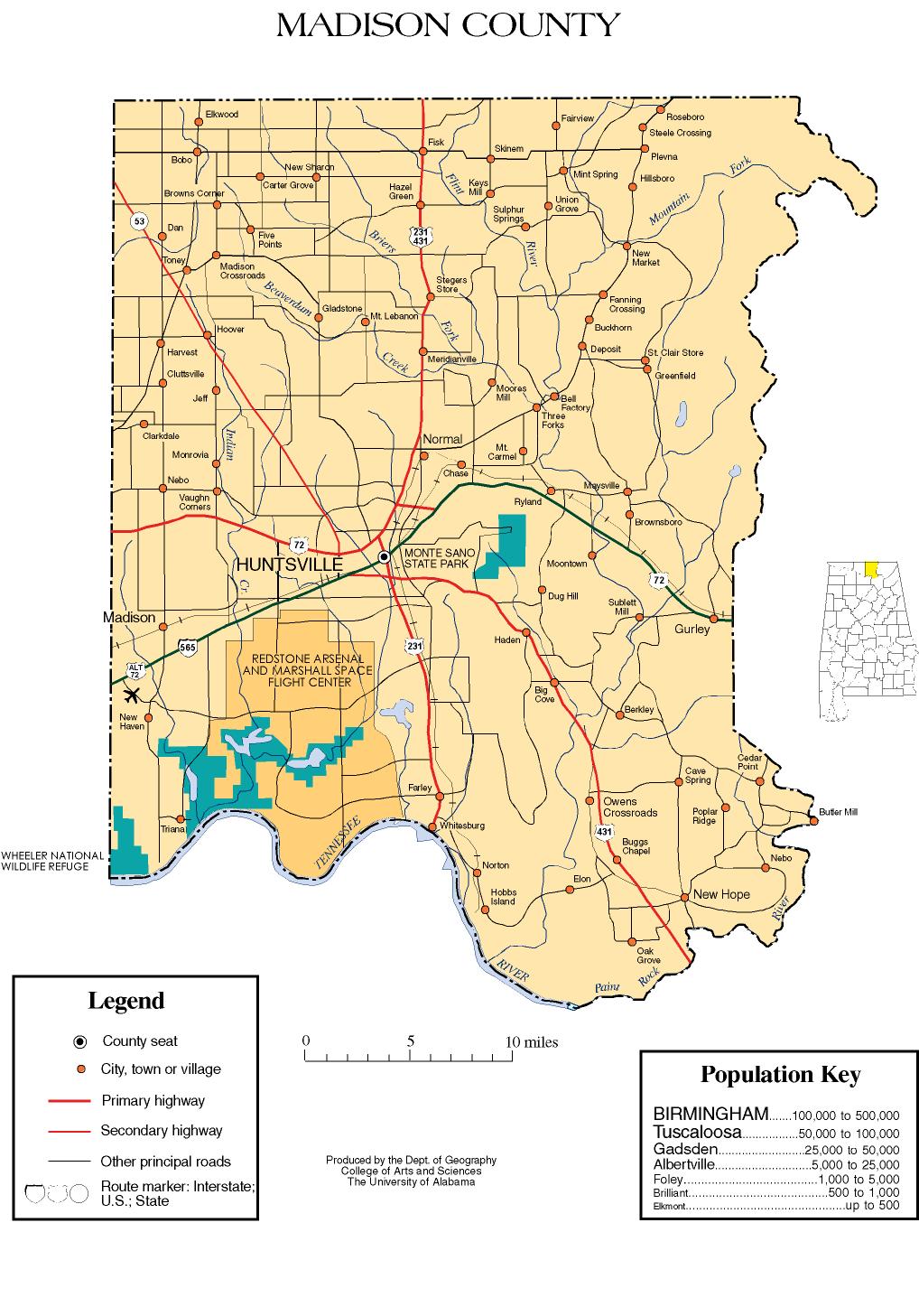
Madison County is a county located in the U.S. state of Arkansas. As of the 2020 census, the population was 16,521. The county seat is Huntsville. The county was formed on September 30, 1836, and named for Madison County, Alabama, the home of some early settlers. They also named the county seat after Madison County in Alabama's county seat, Huntsville.

<span class="mw-page-title-main">Ardmore, Alabama</span> Town in Alabama, United States

Ardmore is a town in Limestone County, Alabama, United States, and is included in the Huntsville-Decatur Metro Area. The population was 1,321 at the 2020 census, It borders its sister city Ardmore, Tennessee.

<span class="mw-page-title-main">Huntsville, Alabama</span> City in North Alabama, US

Huntsville is the most populous city in the U.S. state of Alabama. It is the county seat of Madison County with portions extending into Limestone County and Morgan County. It is located in the Appalachian region of northern Alabama.

<span class="mw-page-title-main">Madison, Alabama</span> City in Alabama, United States

Madison is a city located primarily in Madison County, near the northern border of the U.S. state of Alabama. Madison extends west into neighboring Limestone County. The city is included in the Huntsville Metropolitan Area, the second-largest in the state, and is also included in the merged Huntsville-Decatur Combined Statistical Area. The population was 56,933 at the 2020 census. Madison is bordered by Huntsville on nearly all sides with some small unincorporated lands within Madison in Madison and Limestone counties.

<span class="mw-page-title-main">Gurley, Alabama</span> Town in Alabama, United States

Gurley is a town in Madison County, Alabama, United States, and is included in the Huntsville-Decatur Combined Statistical Area. As of the 2020 census, the population of the town was 816.

<span class="mw-page-title-main">Hazel Green, Alabama</span> Census-designated place in Alabama, United States

Hazel Green is an unincorporated community and census-designated place (CDP) in Madison County, Alabama, United States, and is included in the Huntsville-Decatur Combined Statistical Area. As of the 2020 census, the population of the community was 4,105, up from 3,630 at the 2010 census.

<span class="mw-page-title-main">Meridianville, Alabama</span> Census-designated place in Alabama, United States

Meridianville is an unincorporated community and census-designated place (CDP) in Madison County, Alabama, United States, and is included in the Huntsville-Decatur Combined Statistical Area. As of the 2020 census, the population of the CDP was 8,209.

<span class="mw-page-title-main">Moores Mill, Alabama</span> Census-designated place in Alabama, United States

Moores Mill is an unincorporated community and census-designated place (CDP) in Madison County, Alabama, United States, and is included in the Huntsville-Decatur Combined Statistical Area. The population was 6,729 at the 2020 census, up from 5,682 at the 2010 census.

<span class="mw-page-title-main">New Hope, Alabama</span> City in Alabama, United States

New Hope is a city in Madison County, Alabama, United States, and is included in the Huntsville-Decatur Combined Statistical Area. The population was 2,889 at the 2020 census.

<span class="mw-page-title-main">Owens Cross Roads, Alabama</span> Town in Alabama, United States

Owens Cross Roads is a town in Madison County, Alabama, United States, and is included in the Huntsville-Decatur Combined Statistical Area. It was incorporated on October 9, 1967. The population was 2,594 at the 2020 census.

<span class="mw-page-title-main">Redstone Arsenal</span> United States Army post

Redstone Arsenal is a United States Army base adjacent to Huntsville, Alabama in the Wheeler National Wildlife Refuge. A census-designated place in Madison County, Alabama, United States, it is part of the Huntsville-Decatur Combined Statistical Area. The Arsenal is a host to over 75 tenant agencies including the Department of Defense (DoD), Department of Justice (DOJ), the Federal Bureau of Investigation (FBI), and NASA's largest field center, the Marshall Space Flight Center.

<span class="mw-page-title-main">Triana, Alabama</span> Town in Alabama, United States

Triana is a town in Madison County, Alabama, United States, and is included in the Huntsville-Decatur, AL Combined Statistical Area. The population was 2,890 at the 2020 census, and was estimated to be 3,961 in 2022.

<span class="mw-page-title-main">Huntsville–Decatur combined statistical area</span> Combined Statistical Area in the United States

The Huntsville–Decatur–Albertville, Alabama, combined statistical area is the most populated sub-region of North Alabama, and is the second largest combined statistical area in the State of Alabama after Birmingham. The Huntsville-Decatur-Albertville CSA had a total of 879,315 people in 2022 and ranks 68th in the country.

<span class="mw-page-title-main">Huntsville metropolitan area</span> Metropolitan statistical area in Alabama, US

The Huntsville Metropolitan Statistical Area is a metropolitan statistical area on the northern border of Alabama. The metro area's principal city is Huntsville, and consists of two counties: Limestone and Madison. As of the 2020 United States census, the Huntsville Metropolitan Area's population was 491,723, making it the 2nd-largest metropolitan area in Alabama and the 113th-largest in the United States.

Madison County Schools is a school district in Madison County, Alabama, United States, headquartered in an unincorporated area, bordering Huntsville.

References

  1. 1 2 A Digest of the Laws of the State of Alabama: Containing The Statutes and Resolutions in Force at the end of the General Assembly in January, 1823. Published by Ginn & Curtis, J. & J. Harper, Printers, New-York, 1828. Title 10. Chapter II. Page 80-81. "By Robert Williams, Governor of the Mississippi Territory." (Internet Archive)
  2. Monger, Craig (January 31, 2023). "Ivey appoints former House Speaker McCutcheon as Madison County Commission chairman". 1819 News. Retrieved January 31, 2023.
  3. 1 2 "State & County QuickFacts". United States Census Bureau. Retrieved March 14, 2024.
  4. "Find a County". National Association of Counties. Retrieved June 7, 2011.
  5. Gannett, Henry (1905). The Origin of Certain Place Names in the United States. U.S. Government Printing Office. p.  196.
  6. "1820 Census Reports" (PDF). Census.Gov. c. 1820. Retrieved December 16, 2023.
  7. "1830 US Census Archives". Archives.Gov. September 13, 2021. Retrieved December 16, 2023.
  8. "History | Madison County, AL". www.madisoncountyal.gov. Retrieved December 16, 2023.
  9. "2010 Census Gazetteer Files". United States Census Bureau. August 22, 2012. Retrieved August 22, 2015.
  10. "Annual Estimates of the Resident Population for Counties: April 1, 2020 to July 1, 2023" . Retrieved March 14, 2024.
  11. "U.S. Decennial Census". United States Census Bureau. Retrieved August 22, 2015.
  12. "Historical Census Browser". University of Virginia Library. Retrieved August 22, 2015.
  13. Forstall, Richard L., ed. (March 24, 1995). "Population of Counties by Decennial Census: 1900 to 1990". United States Census Bureau. Retrieved August 22, 2015.
  14. "Census 2000 PHC-T-4. Ranking Tables for Counties: 1990 and 2000" (PDF). United States Census Bureau. April 2, 2001. Retrieved August 22, 2015.
  15. "P004 Hispanic or Latino, And Not Hispanic or Latino by Race – 2000: DEC Summary File 1 – Madison County, Alabama". United States Census Bureau .
  16. "P2 Hispanic or Latino, And Not Hispanic or Latino by Race – 2010: DEC Redistricting Data (PL 94-171) – Madison County, Alabama". United States Census Bureau .
  17. "P2 Hispanic or Latino, And Not Hispanic or Latino by Race - 2020: DEC Redistricting Data (PL 94-171) – Madison County, Alabama". United States Census Bureau .
  18. "US Census Bureau, Table P16: Household Type". United States Census Bureau. Retrieved March 14, 2024.
  19. 1 2 "2020 Census – School District Reference Map: Madison County, AL" (PDF). United States Census Bureau . Retrieved August 1, 2022. - Text list - Huntsville parcel in county schools is on page 4 (PDF p. 5/7).
  20. Phillips, Kevin P.; The Emerging Republican Majority, pp. 214, 261 ISBN   978-0-691-16324-6
  21. "Madison County Commission" . Retrieved November 7, 2020.
  22. "Violet Edwards elected Madison County's first Black woman commissioner". July 17, 2020. Retrieved November 7, 2020.
  23. "Dave Leip's Atlas of U.S. Presidential Elections" . Retrieved November 21, 2016.
  24. Alabama Historical Marker: Lincoln School and Village.

34°45′57″N86°33′28″W / 34.76583°N 86.55778°W / 34.76583; -86.55778