Gurley, Alabama | |
---|---|
Coordinates: 34°42′0″N86°22′35″W / 34.70000°N 86.37639°W | |
Country | United States |
State | Alabama |
County | Madison |
Area | |
• Total | 3.55 sq mi (9.20 km2) |
• Land | 3.55 sq mi (9.19 km2) |
• Water | 0.00 sq mi (0.00 km2) |
Elevation | 965 ft (294 m) |
Population | |
• Total | 816 |
• Density | 229.9/sq mi (88.75/km2) |
Time zone | UTC-6 (Central (CST)) |
• Summer (DST) | UTC-5 (CDT) |
ZIP code | 35748 |
Area code | 256 |
FIPS code | 01-32440 |
GNIS feature ID | 2406631 [2] |
Website | www |
Gurley is a town in Madison County, Alabama, United States, and is included in the Huntsville-Decatur Combined Statistical Area. As of the 2020 census, the population of the town was 816. [3]
The community takes its name from the Gurley family, who settled in the area in 1817. The town gradually formed around a water and coaling stop of the Memphis & Charleston Railroad and was originally known as "Gurley's Tank". In 1866, the post office opened, and the name was changed to "Gurleysville"; it was later shortened back to Gurley. Gurley was incorporated in 1891 with 250 residents. Soon after, the population peaked at 1,000. The business district was nearly destroyed by fire in 1923, when a bucket brigade was able to save only two businesses. Most of the town is now included in the Gurley Historic District, which was listed on the National Register of Historic Places in 2004. [4]
Gurley is located in eastern Madison County at 34°42′1″N86°22′35″W / 34.70028°N 86.37639°W (34.700164, −86.376469), [5] along U.S. Route 72. Huntsville is 16 miles (26 km) to the west, and Scottsboro is 26 miles (42 km) to the east.
According to the U.S. Census Bureau, Gurley has a total area of 3.6 square miles (9.2 km2), all land. [1]
Census | Pop. | Note | %± |
---|---|---|---|
1890 | 570 | — | |
1900 | 831 | 45.8% | |
1910 | 750 | −9.7% | |
1920 | 727 | −3.1% | |
1930 | 581 | −20.1% | |
1970 | 647 | — | |
1980 | 735 | 13.6% | |
1990 | 1,007 | 37.0% | |
2000 | 876 | −13.0% | |
2010 | 801 | −8.6% | |
2020 | 816 | 1.9% | |
U.S. Decennial Census [6] 2013 Estimate [7] |
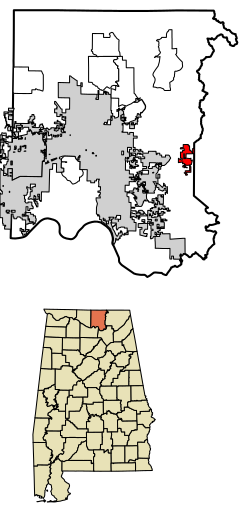
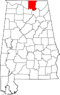
Note: From the 1940 Census until 1970, Gurley ceased to appear on the census rolls. This was likely due to either disincorporation or loss/lapse of its charter in the 1930s. At some point in the 1960s, it was reincorporated.
As of the census [8] of 2000, there were 876 people, 346 households, and 241 families residing in the town. The population density was 313.9 inhabitants per square mile (121.2/km2). There were 379 housing units at an average density of 135.8 per square mile (52.4/km2). The racial makeup of the town was 81.85% White, 15.41% Black or African American, 0.46% Native American, 0.34% Asian, 0.57% from other races, and 1.37% from two or more races. 2.05% of the population were Hispanic or Latino of any race.
There were 346 households, out of which 34.7% had children under the age of 18 living with them, 48.0% were married couples living together, 17.9% had a female householder with no husband present, and 30.1% were non-families. 26.9% of all households were made up of individuals, and 13.0% had someone living alone who was 65 years of age or older. The average household size was 2.53 and the average family size was 3.09.
In the town, the population was spread out, with 28.5% under the age of 18, 7.8% from 18 to 24, 27.1% from 25 to 44, 21.3% from 45 to 64, and 15.3% who were 65 years of age or older. The median age was 35 years. For every 100 females, there were 86.8 males. For every 100 females age 18 and over, there were 85.8 males.
The median income for a household in the town was $23,831, and the median income for a family was $26,875. Males had a median income of $31,146 versus $20,000 for females. The per capita income for the town was $13,271. About 23.4% of families and 21.4% of the population were below the poverty line, including 28.3% of those under age 18 and 31.1% of those age 65 or over.
Race | Num. | Perc. |
---|---|---|
White (non-Hispanic) | 636 | 77.94% |
Black or African American (non-Hispanic) | 71 | 8.7% |
Native American | 9 | 1.1% |
Asian | 8 | 0.98% |
Other/Mixed | 76 | 9.31% |
Hispanic or Latino | 16 | 1.96% |
As of the 2020 United States census, there were 816 people, 253 households, and 153 families residing in the town.
As an incorporated town, Gurley has its own police and fire departments. The city also maintains a small sewer system.
Education in Gurley is run by the Madison County School System. [10] Only one K–8 school (Madison County Elementary) operates within the city limits, in the building formerly occupied by Madison County High School. A new Madison County High School was built a few miles west of the town on US 72 in 1999.
Gurley has its own Masonic Lodge (Gurley Lodge #521 F & AM), a Lions Club, a Lioness Club, and a Founders Club.
Morgan County is a county in the north-central part of the U.S. state of Alabama. As of the 2020 census, its population was 123,421. The county seat is Decatur. On June 14, 1821, it was renamed in honor of American Revolutionary War General Daniel Morgan of Virginia. It is a prohibition or dry county, although alcohol sales are allowed in the cities of Decatur, Hartselle, and Priceville. Morgan County is included in the Decatur, AL Metropolitan Statistical Area, which is also included in the Huntsville-Decatur-Albertville, AL Combined Statistical Area. It is a part of the North, Northwest, and North-Central regions of Alabama.
Limestone County is a county of the U.S. state of Alabama. As of the 2020 census, the county's population was 103,570. Its county seat is Athens. The county is named after Limestone Creek. Limestone County is included in the Huntsville, AL Metropolitan Statistical Area.
Madison County is located in the north central portion of the U.S. state of Alabama. As of the 2020 Census, the population was 388,153, making it the third-most populous county in Alabama. Its county seat is Huntsville. Since the mid-20th century it has become an area of defense and space research and industry.
Paint Rock is a town in Jackson County, Alabama, United States, along the Paint Rock River, and is included in the Huntsville-Decatur Combined Statistical Area. It was incorporated in July 1894.
Woodville is a town in Jackson County, Alabama, United States. It was officially established by an act of the Alabama State Legislature on December 13, 1819, one day before Alabama became a state. It was later incorporated on May 12, 1890, but lost its charter in 1897. It reincorporated in 1912. As of the 2010 census, the population of the town is 746, down from 761 in 2000.
Argo is a town in Jefferson and St. Clair counties, Alabama, United States. It incorporated in 1987. At the 2020 census, the population was 4,368.
Ardmore is a town in Limestone County, Alabama, United States, and is included in the Huntsville-Decatur Metro Area. As of the 2010 census, the population of the town is 1,194. It borders its sister city Ardmore, Tennessee.
Madison is a city located primarily in Madison County, near the northern border of the U.S. state of Alabama. Madison extends west into neighboring Limestone County. The city is included in the Huntsville Metropolitan Area, the second-largest in the state, and is also included in the merged Huntsville-Decatur Combined Statistical Area. As of the 2020 census, the population of the city was 56,933, an increase over the 42,938 from the 2010 census. Madison is bordered by Huntsville on nearly all sides with some small unincorporated lands within Madison in Madison and Limestone counties.
Harvest is an unincorporated community and census-designated place (CDP) in the northwestern part of Madison County, Alabama, United States, and is included in the Huntsville-Decatur Combined Statistical Area. According to the 2020 U.S. Census, the population of the community is 5,893.
Hazel Green is an unincorporated community and census-designated place (CDP) in Madison County, Alabama, United States, and is included in the Huntsville-Decatur Combined Statistical Area. As of the 2020 census, the population of the community was 4,105, up from 3,630 at the 2010 census.
Meridianville is an unincorporated community and census-designated place (CDP) in Madison County, Alabama, United States, and is included in the Huntsville-Decatur Combined Statistical Area. As of the 2020 census, the population of the CDP was 8,209.
Moores Mill is an unincorporated community and census-designated place (CDP) in Madison County, Alabama, United States, and is included in the Huntsville-Decatur Combined Statistical Area. The population was 6,729 at the 2020 census, up from 5,682 at the 2010 census.
New Hope is a city in Madison County, Alabama, United States, and is included in the Huntsville-Decatur Combined Statistical Area. As of the 2020 census, the population was 2,889.
New Market is an unincorporated community and census-designated place (CDP) in Madison County, Alabama, United States, and is included in the Huntsville-Decatur Combined Statistical Area. As of the 2020 census, the population of the CDP was 1,543. Although it was the first area settled in Madison County, the town has never been incorporated.
Owens Cross Roads is a city in Madison County, Alabama, United States, and is included in the Huntsville-Decatur Combined Statistical Area. It was incorporated in 1967. As of the 2020 census, the population of the city was 2,594. The City has a mayor-council form of government.
Triana is a town in Madison County, Alabama, United States, and is included in the Huntsville-Decatur Combined Statistical Area. As of the 2020 census, the population of the town was 2,890, up from 496 at the 2010 census.
Priceville is the third largest municipality in Morgan County, Alabama, United States and is included in the Decatur Metropolitan Area, as well as the Huntsville-Decatur Combined Statistical Area. The 2020 census counted a population of 3,513, up from 2,658 in 2010.
Hindsville is a town in Madison County, Arkansas, United States. The population was 90 at the 2020 census. It is part of the Northwest Arkansas region.
Huntsville is a city in and county seat of Madison County, Arkansas, United States. The population was 2,879 at the 2020 census, up from 2,346 in 2010. During the American Civil War in 1862, it was the site of what became known as the Huntsville Massacre. Huntsville is part of the Northwest Arkansas region.
Northeast Madison Township is a township in Perry County, Pennsylvania, United States. The population was 828 at the 2020 census.