
Madison County is located in the north central portion of the U.S. state of Alabama. As of the 2020 Census, the population was 388,153, making it the second-most populous county in Alabama. Its county seat is Huntsville. Since the mid-20th century it has become an area of defense and space research and industry.

Huntsville is the most populous city in the U.S. state of Alabama. It is the county seat of Madison County with portions extending into Limestone County and Morgan County. It is located in the Appalachian region of northern Alabama.

Madison is a city located primarily in Madison County, near the northern border of the U.S. state of Alabama. Madison extends west into neighboring Limestone County. The city is included in the Huntsville Metropolitan Area, the second-largest in the state, and is also included in the merged Huntsville-Decatur Combined Statistical Area. The population was 56,933 at the 2020 census. Madison is bordered by Huntsville on nearly all sides with some small unincorporated lands within Madison in Madison and Limestone counties.

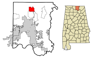
Harvest is an unincorporated community and census-designated place (CDP) in the northwestern part of Madison County, Alabama, United States, and is included in the Huntsville-Decatur Combined Statistical Area. According to the 2020 U.S. Census, the population of the community is 5,893.
Hazel Green is an unincorporated community and census-designated place (CDP) in Madison County, Alabama, United States, and is included in the Huntsville-Decatur Combined Statistical Area. As of the 2020 census, the population of the community was 4,105, up from 3,630 at the 2010 census.
Monte Sano Mountain is a mountain located in Huntsville, Alabama. The name Monte Sano is Spanish for "Mountain of health". The mountain was given its name by Dr. Thomas Fern, who along with his two brothers, founded a small colony on the mountain during an epidemic of yellow fever, malaria, and cholera. The location on the mountain was chosen because of its cool air and medicinal springs.
Morgan City, also known as New Rescue, is an unincorporated community located in Morgan and Marshall counties, Alabama, United States. It is included in the Huntsville-Decatur Combined Statistical Area, as well as the Decatur Metropolitan Area.
Tanner is an unincorporated community in central southern Limestone County, Alabama, United States, and is included in the Huntsville-Decatur Combined Statistical Area. It lies nine miles north of the city of Decatur and the Tennessee River, and four miles south of the city of Athens.

The Huntsville–Decatur–Albertville, Alabama, combined statistical area is the most populated sub-region of North Alabama, and is the second largest combined statistical area in the State of Alabama after Birmingham. The Huntsville-Decatur-Albertville CSA had a total of 879,315 people in 2022 and ranks 68th in the country.

Genesee Depot is a small unincorporated community in Waukesha County, Wisconsin, United States. It is in the Town of Genesee, in southeastern Wisconsin between Milwaukee and Madison, and named for the train station, or depot, of the Wisconsin and Calumet Railroad that formerly served the town.
Bexar is a rural, mostly agricultural community in extreme west Marion County, Alabama, United States, approximately three miles from the Alabama - Mississippi state line.
Monrovia, also known as Vaughn Corners or Thompson Mill, is an unincorporated community in Madison County, Alabama, United States. It is bordered on the south by the city of Madison, on the southeast by the city of Huntsville, on the west by Limestone County and on the north by the community of Harvest.
Huntsville is an unincorporated community in Fall Creek Township, Madison County, Indiana.
New Columbus is an unincorporated community in Adams Township, Madison County, Indiana, United States. It is also known as Ovid, and is marked by both names on highway signs at the town's borders.
Half Acre is an unincorporated community in Marengo County, Alabama, United States. It has gone through a variety of name changes since the early 20th century. The community had a post office at one time, but it no longer exists. Although a thriving community in its early years, it has since dwindled into obscurity.
Capshaw, formerly known as Lux, is an unincorporated community in eastern Limestone County, Alabama, United States. It is located at the intersection of Capshaw, Sanderson and NW Dupree Worthey Roads. It is now mostly a part of Huntsville with the southern portion near Highway 72 being part of Madison City.
Oakland is an unincorporated community in Limestone County, Alabama, United States. It is in the eastern part of the county near Madison at the intersection of Huntsville Brownsferry Road and County Road 119, as opposed to Oakland, Limestone County, Alabama which is just west of Athens.

Limestone Creek is 45.5 miles (73.2 km) long with a drainage area of 144.3 square miles (374 km2), and is a tributary to the Tennessee River. The river rises in Lincoln County, Tennessee, and flows south into Madison County, Alabama before flowing through Limestone County, Alabama, where most of the river's watershed is located. In fact, Limestone Creek is where Limestone County gets its name. Limestone Creek terminates in the Tennessee River at Arrowhead Landing, which is the southeasternmost point of Limestone County's Wheeler National Wildlife Refuge. The land within this watershed is predominantly agricultural, but has experienced significant recent residential growth from the city of Huntsville.
Madison County Schools is a school district in Madison County, Alabama, United States, headquartered in an unincorporated area, bordering Huntsville.

Calcis is an unincorporated community in Shelby County, Alabama, United States, located along Alabama State Route 25, 3 miles (4.8 km) north-northwest of Vincent.


