Luverne | |
---|---|
City | |
Nickname: "Friendliest City in the South" [1] | |
Coordinates: 31°42′52″N86°15′48″W / 31.71444°N 86.26333°W | |
Country | United States |
State | Alabama |
County | Crenshaw |
Founded | 1889 |
Incorporated | February 6, 1891 |
Founded by | M.P. Legrand, S.D. Hubbard, and George A. Folmar |
Government | |
• Type | Mayor–council |
• Mayor | Ed Beasley |
Area | |
• Total | 15.67 sq mi (40.60 km2) |
• Land | 15.65 sq mi (40.53 km2) |
• Water | 0.03 sq mi (0.07 km2) |
Elevation | 354 ft (108 m) |
Population (2020) | |
• Total | 2,765 |
• Density | 176.71/sq mi (68.23/km2) |
Time zone | UTC-6 (Central (CST)) |
• Summer (DST) | UTC-5 (CDT) |
ZIP Code | 36049 |
Area code | 334 |
FIPS code | 01-44728 |
GNIS feature ID | 0122110 |
Website | www |
Luverne is a city in and the county seat of Crenshaw County, Alabama, United States. The city describes itself as "The Friendliest City in the South", a slogan that appears on its "welcome" signs. [3] At the 2020 census, the population was 2,765.
Luverne was one of numerous towns developed in the state as a result of railroad construction.
On July 2, 1880, the Montgomery and Southern Railway was created to construct a new railroad linking Montgomery to the Florida coast. The company completed around 30 miles (48 km) of narrow gauge track by September 18, 1882. The company was reorganized as the Montgomery and Florida Railway in May 1886, and a second time as the Northwest and Florida Railroad in 1888. In November 1888, the railroad reached the site of Luverne in the central part of Crenshaw County, near the Patsaliga River. Now totaling 51 miles (82 km) the line was converted to standard gauge by July 1889 and it was decided to proceed no further. The Alabama Terminal and Improvement Company, a subsidiary of the Alabama Midland Railway , controlled the railroad by 1889 and the line from Montgomery to Luverne was into the network of the latter. [4]
The new railroad terminus attracted related development, and the town grew. It was incorporated in 1891, and became a center of timbering in the Piney Woods of southern Alabama, as the land was not fertile enough to be suitable for large-scale cotton plantation agriculture.
In 1893, the citizens of Crenshaw County voted to move the county seat from Rutledge to the more populous Luverne. [5]
By the late 1930s, lynchings of African Americans were increasingly conducted in small groups or in secret, rather than in the former mass public displays. [6] On June 22, 1940, an African-American man named Jesse Thornton was lynched in Luverne for failing to address a white man with the title of "Mister". He was fatally shot and his body was later found in the Patsaliga River. [7] The Equal Justice Initiative documented that the white man Thornton had apparently offended by his Jim Crow infraction was a police officer. [8] This was the only lynching recorded in the county.
Luverne is located at 31°42′52″N86°15′48″W / 31.714427°N 86.263323°W . [9] The town of Rutledge lies along Luverne's western border.
According to the U.S. Census Bureau, the city has a total area of 15.7 square miles (40.6 km2), of which 15.6 square miles (40.5 km2) is land and 0.04 square miles (0.1 km2), or 0.17%, is water. [10]
According to the Köppen climate classification, Luverne has a humid subtropical climate (abbreviated Cfa).
Climate data for Luverne, 1991–2020 simulated normals (341 ft elevation) | |||||||||||||
---|---|---|---|---|---|---|---|---|---|---|---|---|---|
Month | Jan | Feb | Mar | Apr | May | Jun | Jul | Aug | Sep | Oct | Nov | Dec | Year |
Mean daily maximum °F (°C) | 59.2 (15.1) | 63.5 (17.5) | 70.7 (21.5) | 77.2 (25.1) | 84.6 (29.2) | 89.4 (31.9) | 91.4 (33.0) | 90.9 (32.7) | 87.4 (30.8) | 79.0 (26.1) | 69.1 (20.6) | 61.7 (16.5) | 77.0 (25.0) |
Daily mean °F (°C) | 47.5 (8.6) | 51.3 (10.7) | 58.1 (14.5) | 64.4 (18.0) | 72.3 (22.4) | 78.8 (26.0) | 81.1 (27.3) | 80.6 (27.0) | 76.5 (24.7) | 66.6 (19.2) | 56.1 (13.4) | 50.4 (10.2) | 65.3 (18.5) |
Mean daily minimum °F (°C) | 35.8 (2.1) | 39.2 (4.0) | 45.3 (7.4) | 51.6 (10.9) | 60.1 (15.6) | 68.0 (20.0) | 70.7 (21.5) | 70.3 (21.3) | 65.5 (18.6) | 54.1 (12.3) | 43.2 (6.2) | 38.8 (3.8) | 53.6 (12.0) |
Average precipitation inches (mm) | 5.16 (130.98) | 4.73 (120.14) | 5.28 (134.13) | 4.63 (117.69) | 3.71 (94.31) | 5.25 (133.41) | 5.80 (147.36) | 5.14 (130.68) | 4.26 (108.16) | 3.34 (84.75) | 4.29 (108.85) | 5.31 (134.84) | 56.9 (1,445.3) |
Average dew point °F (°C) | 38.5 (3.6) | 41.4 (5.2) | 46.0 (7.8) | 52.5 (11.4) | 60.8 (16.0) | 68.2 (20.1) | 71.1 (21.7) | 70.7 (21.5) | 66.2 (19.0) | 55.9 (13.3) | 46.6 (8.1) | 41.9 (5.5) | 55.0 (12.8) |
Source: PRISM Climate Group [11] |
Census | Pop. | Note | %± |
---|---|---|---|
1890 | 451 | — | |
1900 | 731 | 62.1% | |
1910 | 1,384 | 89.3% | |
1920 | 1,464 | 5.8% | |
1930 | 1,874 | 28.0% | |
1940 | 2,243 | 19.7% | |
1950 | 2,221 | −1.0% | |
1960 | 2,238 | 0.8% | |
1970 | 2,440 | 9.0% | |
1980 | 2,639 | 8.2% | |
1990 | 2,555 | −3.2% | |
2000 | 2,635 | 3.1% | |
2010 | 2,800 | 6.3% | |
2020 | 2,765 | −1.2% | |
U.S. Decennial Census [12] 2013 Estimate [13] |
As of the census [14] of 2000, there were 2,635 people, 1,107 households, and 710 families living in the city. [15] The population density was 212.7 inhabitants per square mile (82.1/km2). There were 1,249 housing units at an average density of 100.8 per square mile (38.9/km2). [16] The racial makeup of the city was 70.25% White, 28.43% Black or African American, 0.08% Native American, 0.15% Asian, 0.04% Pacific Islander, 0.11% from other races, and 0.95% from two or more races. 0.68% of the population were Hispanic or Latino of any race. [15]
Of the 1,107 households 28.9% had children under the age of 18 living with them, 42.7% were married couples living together (2.4% same-sex couples), 19.5% had a female householder with no husband present, and 35.8% were non-families. 33.8% of households were one person and 19.2% were one person aged 65 or older. The average household size was 2.24 and the average family size was 2.85. [15]
The age distribution was 23.0% under the age of 18, 6.8% from 18 to 24, 23.4% from 25 to 44, 23.3% from 45 to 64, and 23.4% 65 or older. The median age was 42 years. For every 100 females, there were 77.0 males. For every 100 females age 18 and over, there were 71.1 males. [15]
The median household income was $22,457 and the median family income was $30,950. Males had a median income of $30,680 versus $17,813 for females. The per capita income for the city was $17,244. About 19.2% of families and 22.7% of the population were below the poverty line, including 31.3% of those under age 18 and 18.9% of those age 65 or over. [15]
As of the census [17] of 2010, there were 2,800 people, 1,135 households, and 729 families living in the city. The racial makeup of the city was 62.6% White, 29.6% Black or African American, 0.3% Native American, 5.5% Asian, 0.3% Pacific Islander, 0.8% from other races, and 1.0% from two or more races. 1.9% of the population were Hispanic or Latino of any race.
Of the 1,135 households 26.9% had children under the age of 18 living with them, 41.7% were married couples living together (2.4% same-sex couples), 19.2% had a female householder with no husband present, and 35.8% were non-families. 32.8% of households were one person and 14.8% were one person aged 65 or older. The average household size was 2.35 and the average family size was 2.95.
The age distribution was 23.8% under the age of 18, 7.9% from 18 to 24, 22.4% from 25 to 44, 26.3% from 45 to 64, and 19.7% 65 or older. The median age was 41.2 years. For every 100 females, there were 84.6 males. For every 100 females age 18 and over, there were 85.3 males.
The median household income was $40,602 and the median family income was $51,500. Males had a median income of $43,464 versus $19,483 for females. The per capita income for the city was $18,869. About 12.6% of families and 15.8% of the population were below the poverty line, including 11.8% of those under age 18 and 20.6% of those age 65 or over.
Race | Num. | Perc. |
---|---|---|
White (non-Hispanic) | 1,707 | 61.74% |
Black or African American (non-Hispanic) | 858 | 31.03% |
Native American | 2 | 0.07% |
Asian | 37 | 1.34% |
Pacific Islander | 2 | 0.07% |
Other/Mixed | 119 | 4.3% |
Hispanic or Latino | 40 | 1.45% |
As of the 2020 United States census, there were 2,765 people, 1,005 households, and 634 families residing in the city.
Public education for the city of Luverne is provided by the Crenshaw County School District. There are two schools in the city: Luverne High School (grades K through 12) and Crenshaw Christian Academy, a private, religiously oriented K-12 school.
Lurleen B. Wallace Community College offers certificate and two-year associate degrees at its Luverne location.
Etowah County is a county located in the northeastern part of the U.S. state of Alabama. As of the 2020 census the population was 103,436. Its county seat is Gadsden. Its name is from a Cherokee word meaning "edible tree". In total area, it is the smallest county in Alabama, but one of the most densely populated. Etowah County comprises the Gadsden Metropolitan Statistical Area.
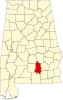
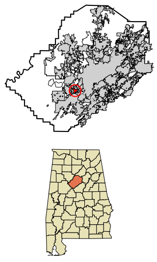
Crenshaw County is a county located in the south central portion of the U.S. state of Alabama. It is located immediately south of the Montgomery metropolitan area. As of the 2020 census, the population was 13,194. Its county seat is Luverne. Its name is in honor of an Alabama judge, Anderson Crenshaw.
Elmore County is a county located in the east central portion of the U.S. state of Alabama. As of the 2020 census, the population was 87,977. Its county seat is Wetumpka. Its name is in honor of General John A. Elmore.
Henry County is a county in the southeastern part of the U.S. state of Alabama. As of the 2020 census, its population was 17,146. Its county seat is Abbeville. The county was named for Patrick Henry (1736–1799), famous orator and Governor of Virginia.
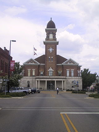
Pike County is located in the U.S. state of Alabama. As of the 2020 census the population was 33,009. Its county seat is Troy. Its name is in honor of General Zebulon Pike, of New Jersey, who led an expedition to southern Colorado and encountered Pikes Peak in 1806.
Greenville is a city and the county seat of Butler County, Alabama, United States. At the 2020 census, the population was 7,374. Greenville is known as the Camellia City, wherein originated the movement to change the official Alabama state flower from the goldenrod to the camellia with legislative sponsors LaMont Glass and H.B. Taylor.
Calera is a city in Shelby and Chilton counties in the U.S. state of Alabama. It is the location of the Shelby County Airport.
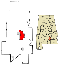
Brantley is a city in Crenshaw County, Alabama, United States. At the 2020 census, the population was 825. Brantley was incorporated in 1891 as a city.
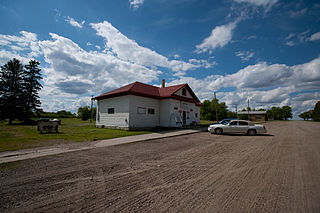
Dozier is a town in Crenshaw County, Alabama, United States. At the 2020 census, the population was 285. Dozier was incorporated in 1907.
Glenwood is a town in Crenshaw County, Alabama, United States. At the 2020 census, the population was 152. Glenwood was incorporated in 1907.
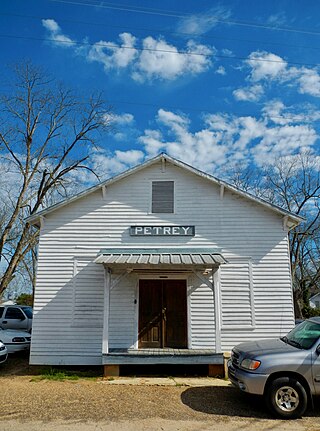
Petrey is a town in Crenshaw County, Alabama, United States. The population was 58 at the 2010 census.
Rutledge is a town in Crenshaw County, Alabama, United States. As of the 2010 census, the population of the town was 467.
Abbeville is a city in and the county seat of Henry County, in the southeast part of Alabama, United States. It is part of the Dothan, Alabama Metropolitan Statistical Area. At the 2020 census, the population was 2,358.
Brighton is a city near Birmingham, Alabama, United States and located just east of Hueytown. At the 2020 census, the population was 2,337. It is part of the Birmingham-Hoover Metropolitan Statistical Area, which in 2010 had a population of about 1,128,047, approximately one-quarter of Alabama's population.
Pelham is a city in Shelby County, Alabama, United States. The population was 24,318 at the 2020 census, It incorporated on July 10, 1964 and is a suburb located in the Birmingham metropolitan area, Alabama which was home to nearly 1.2 million residents as of the 2020 census. It was named for Confederate Civil War officer John Pelham.
Ashville is a city in and one of the county seats of St. Clair County, Alabama, United States, other seat being Pell City. Its population was 2,212 at the 2010 census, down from 2,260, at which time it was a town. It incorporated in 1822.
Bogue is a town in Carteret County, North Carolina, United States. The population was 684 in 2010.
Luverne is a city in Steele County, North Dakota, United States. The population was 28 at the 2020 census. Luverne was founded in 1912.
Crenshaw is a town in Panola and Quitman counties in the U.S. state of Mississippi. The population was 885 at the 2010 census.
Eupora is the largest city in Webster County, central Mississippi. The population was 2,197 at the 2010 census.
luverne friendliest city in the south.
In 1940, Jesse Thornton was lynched in Luverne, Alabama, for referring to a white police officer by his name without the title of "mister."