Prattville | |
|---|---|
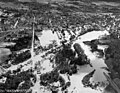
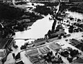
 Downtown Prattville | |
 Flag 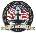 Seal | |
| Nickname: The Fountain City | |
| Motto: "The Preferred Community" | |
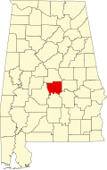
 Location of Prattville in Autauga County and Elmore County, Alabama. | |
| Coordinates: 32°27′53″N86°27′25″W / 32.46472°N 86.45694°W [1] | |
| Country | United States |
| State | Alabama |
| Counties | Autauga, Elmore |
| Founded | 1839 |
| Named after | Daniel Pratt |
| Government | |
| • Type | Mayor-council |
| Area | |
• Total | 36.29 sq mi (94.00 km2) |
| • Land | 35.41 sq mi (91.71 km2) |
| • Water | 0.88 sq mi (2.29 km2) |
| Elevation | 276 ft (84 m) |
| Population (2020) | |
• Total | 37,781 |
| • Density | 1,067.0/sq mi (411.96/km2) |
| Time zone | UTC−6 (CST) |
| • Summer (DST) | UTC−5 (CDT) |
| ZIP codes | 36066-36068 |
| Area code | 334 |
| FIPS code | 01-62328 |
| GNIS feature ID | 2404568 [1] |
| Website | www |
Prattville is a city located within both Autauga and Elmore counties in the State of Alabama, United States, and serves as the county seat of Autauga County. As of the 2020 census, the population of the city was 37,781. Nicknamed "The Fountain City" due to the many artesian wells in the area, Prattville is part of the Montgomery Metropolitan Area. It was founded by Daniel Pratt.