Hayneville, Alabama

Last updated

Hayneville, Alabama
Hayneville, Alabama.JPG
Hayneville Courthouse Square
Lowndes County Alabama Incorporated and Unincorporated areas Hayneville Highlighted 0133712.svg
Location of Hayneville in Lowndes County, Alabama.
Coordinates: 32°10′57″N86°34′50″W / 32.18250°N 86.58056°W / 32.18250; -86.58056
Country United States
State Alabama
County Lowndes
Government
  MayorHelenor Bell
Area
[1]
  Total1.88 sq mi (4.86 km2)
  Land1.86 sq mi (4.82 km2)
  Water0.02 sq mi (0.04 km2)
Elevation
243 ft (74 m)
Population
 (2020)
  Total830
  Density446.00/sq mi (172.16/km2)
Time zone UTC-6 (Central (CST))
  Summer (DST) UTC-5 (CDT)
ZIP code
36040
Area code 334
FIPS code 01-33712
GNIS feature ID0119902

Hayneville is a town in Lowndes County, Alabama, United States and its county seat. At the 2010 census the population was 932, down from its record high of 1,177 in 2000. It is also part of the Montgomery Metropolitan Statistical Area. It initially incorporated in 1831, [2] but lapsed, finally reincorporating in 1967. Before 1970, the town appeared only twice on the U.S. Census: in 1850 [3] and 1890. [4] The 1850 estimate of 800 residents ranked it as the largest town in the county at the time.

Contents

Located in the fertile Black Belt region, Hayneville was the county seat in a plantation economy after Native Americans were removed that used slave labor for cotton production. The town was later a railway terminus and home to the Hayneville Railway Company, which was organized in 1903. Two years later, the company was reorganized as the Hayneville & Montgomery Railroad Company and provided connections for shipping with the L&N Railroad Company's tracks.

History

Settlement (1820-1831)

Hayneville was founded in 1820 by settlers from the Edgefield, Abbeville, and Colleton districts of South Carolina on property purchased from the U.S. Land Office at Cahawba. Throughout the 1820s, Hayneville was known as "Big Swamp". The indigenous Muscogee Creek people had been forced to cede their lands under various treaties with the United States, and most of them were removed to Indian Territory west of the Mississippi River.

In 1831, after being chosen as the county seat of Lowndes County, the town was officially named Hayneville in honor of Robert Y. Hayne, governor of South Carolina and a U.S. senator.

Late 19th and early 20th century

During the early part of the 20th century, the boll weevil invaded the South, destroying cotton crops across the most productive counties. In the latter half of the 20th century, the agricultural focus shifted to more diverse crops and livestock. Hayneville, like the rest of the Black Belt, has struggled to develop a prosperous economy. [5] Lowndes County Training School was established in Hayneville in 1913.

Civil Rights Era and "Bloody Lowndes" (1965)

Despite the county's black majority, it had no registered black voters in the spring of 1965, after more than 60 years of disenfranchisement under the Alabama Constitution. Civil rights activists worked in Hayneville and Lowndes to organize residents in preparation for registration and voting. After passage of the federal Voting Rights Act of 1965 in August, activists provided residents with political education and helped them register to vote. They continued to work to integrate stores and public facilities. On August 13, 1965, Jonathan Daniels, an Episcopal seminarian from New Hampshire, worked with a group of 29 civil rights protesters to picket whites-only stores in the small town of Fort Deposit. All of the protesters were arrested by county police and taken to jail in nearby Hayneville. Five juvenile protesters were released the next day. The rest of the group was held for six days; they refused to accept bail unless everyone was bailed.

On August 20, the prisoners were released without transport back to Fort Deposit. After release, the group waited by a road nearby the jail. Daniels, along with three others — a white Catholic priest and two black women activists—went to buy soft drinks at Varner's Grocery Store, one of the few local stores that would serve non-whites. There, they encountered Tom L. Coleman, an engineer for the state highway department and unpaid special county deputy wielding a shotgun. The man threatened the group, and finally leveled his gun at seventeen-year-old Ruby Sales. Daniels pushed Sales to the ground and caught the full blast of the gun, which killed him instantly. Father Richard F. Morrisroe grabbed the other protester and ran. Coleman shot Morrisroe, wounding him in the lower back. [6] White resistance to civil rights organizers continued.

In June 1965, Gregory Orr, a student from upstate New York who traveled to Mississippi to take part in civil rights protests, was driving home from the capital of Jackson. He had been arrested there with other protesters and held without charges for 10 days at the state fairgrounds. While driving through Lowndes County, he was stopped by white vigilantes, kidnapped and held without charges for eight days in the Hayneville courthouse jail. Back in New York that August, Orr read a report of the murder of Jonathan Daniels in The New York Times. [6] He recognized one of his kidnappers in a photograph—apparently Tom Coleman. [7] Numerous other incidents have been documented in the county of violence against civil rights people.

Civil rights activities in Lowndes continued in the county under the leadership of Stokeley Carmichael, the Student Nonviolent Coordinating Committee (SNCC) and local residents, to educate and register blacks to vote after passage of the Voting Rights Act of 1965. They organized the Lowndes County Freedom Organization (LFCO), the first independent black political party in the county since Reconstruction era, and continued to register voters. They ran a slate of candidates in 1966 but lost due to election fraud in the majority-black county. In 1970, African-American chairman of LCFO John Hulett was elected as county sheriff.

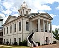
Incorporation (1967-1968)

The incorporation of Hayneville as a town began in July 1967 with the vision of 25 qualified electors of the county and residents of the Hayneville community. Two subsequent attempts were made for incorporation, the last resulting in favor of incorporation. Only one person filed for a statement of candidacy and was nominated for the office of Mayor and five places on the town council. Therefore, due to the completion of the requirements of incorporation, the court declared on July 15, 1968, by Probate Judge Harold Hammond, that Hayneville was completely incorporated.

Geography

Hayneville is located at 32°10′57″N86°34′50″W / 32.18250°N 86.58056°W / 32.18250; -86.58056 (32.182365, -86.580468). [8]

According to the U.S. Census Bureau, the town has a total area of 1.9 square miles (4.9 km2), of which 1.9 square miles (4.9 km2) is land and 0.54% is water.

Climate

According to the Köppen climate classification, Hayneville has a humid subtropical climate (abbreviated Cfa).

Climate data for Hayneville, 1991–2020 simulated normals (230 ft elevation)
MonthJanFebMarAprMayJunJulAugSepOctNovDecYear
Mean daily maximum °F (°C)57.7
(14.3)
62.1
(16.7)
69.6
(20.9)
76.5
(24.7)
83.8
(28.8)
89.1
(31.7)
91.6
(33.1)
91.2
(32.9)
87.3
(30.7)
77.9
(25.5)
67.6
(19.8)
59.9
(15.5)
76.2
(24.5)
Daily mean °F (°C)46.9
(8.3)
50.9
(10.5)
57.7
(14.3)
64.6
(18.1)
72.5
(22.5)
79.0
(26.1)
81.7
(27.6)
81.3
(27.4)
76.6
(24.8)
66.2
(19.0)
55.4
(13.0)
49.1
(9.5)
65.2
(18.4)
Mean daily minimum °F (°C)36.1
(2.3)
39.6
(4.2)
46.0
(7.8)
52.5
(11.4)
61.3
(16.3)
68.9
(20.5)
71.8
(22.1)
71.2
(21.8)
66.0
(18.9)
54.5
(12.5)
43.2
(6.2)
38.3
(3.5)
54.1
(12.3)
Average precipitation inches (mm)5.09
(129.34)
4.99
(126.86)
5.40
(137.27)
4.21
(106.98)
4.01
(101.84)
4.63
(117.55)
5.20
(132.10)
4.23
(107.53)
3.88
(98.57)
3.07
(77.98)
4.12
(104.67)
5.24
(133.15)
54.07
(1,373.84)
Average dew point °F (°C)37.9
(3.3)
40.8
(4.9)
45.9
(7.7)
52.7
(11.5)
61.2
(16.2)
68.4
(20.2)
71.4
(21.9)
70.9
(21.6)
66.2
(19.0)
55.9
(13.3)
46.0
(7.8)
41.0
(5.0)
54.9
(12.7)
Source: PRISM Climate Group [9]

Demographics

Historical population
CensusPop.Note
1850 800
1890 355
1970 473
1980 59225.2%
1990 96963.7%
2000 1,17721.5%
2010 932−20.8%
2020 830−10.9%
U.S. Decennial Census [10]
2013 Estimate [11]

2020 census

Hayneville town, Alabama – Racial and ethnic composition
Note: the US Census treats Hispanic/Latino as an ethnic category. This table excludes Latinos from the racial categories and assigns them to a separate category. Hispanics/Latinos may be of any race.
Race / Ethnicity (NH = Non-Hispanic)Pop 2010 [12] Pop 2020 [13] % 2010% 2020
White alone (NH)14012615.02%15.18%
Black or African American alone (NH)78769684.44%83.86%
Native American or Alaska Native alone (NH)000.00%0.00%
Asian alone (NH)020.00%0.24%
Pacific Islander alone (NH)000.00%0.00%
Some Other Race alone (NH)100.11%0.00%
Mixed Race or Multi-Racial (NH)320.32%0.24%
Hispanic or Latino (any race)140.11%0.48%
Total932830100.00%100.00%

As of the census [14] of 2000, there were 1,177 people, 409 households, and 294 families residing in the town. The population density was 635.3 inhabitants per square mile (245.3/km2). There were 467 housing units at an average density of 252.1 per square mile (97.3/km2). The racial makeup of the town was 85.47% Black or African American, 13.42% White, 0.17% Asian, and 0.93% from two or more races. 0.34% of the population were Hispanic or Latino of any race.

There were 409 households, out of which 37.7% had children under the age of 18 living with them, 34.7% were married couples living together, 33.5% had a female householder with no husband present, and 28.1% were non-families. 27.1% of all households were made up of individuals, and 10.5% had someone living alone who was 65 years of age or older. The average household size was 2.80 and the average family size was 3.45.

In the town, the population was spread out, with 32.7% under the age of 18, 11.8% from 18 to 24, 25.1% from 25 to 44, 17.8% from 45 to 64, and 12.6% who were 65 years of age or older. The median age was 30 years. For every 100 females, there were 88.0 males. For every 100 females age 18 and over, there were 81.7 males.

The median income for a household in the town was $19,554, and the median income for a family was $22,788. Males had a median income of $22,396 versus $20,417 for females. The per capita income for the town was $9,556. About 35.2% of families and 35.8% of the population were below the poverty line, including 42.3% of those under age 18 and 28.1% of those age 65 or over.

Education

Central High School, formerly Lowndes County Training School, is in Hayneville. Alumni include the Negro league and Major League Baseball player Billy Parker, [15] civil rights activist Catherine Coleman Flowers, [16] and professional basketball player Ben Wallace. [17]

Notable people

See also

Related Research Articles

<span class="mw-page-title-main">Montgomery County, Alabama</span> County in Alabama, United States

Montgomery County is located in the State of Alabama. As of the 2020 census, its population was 228,954, making it the seventh-most populous county in Alabama. Its county seat is Montgomery, the state capital. Montgomery County is included in the Montgomery, AL Metropolitan Statistical Area.

<span class="mw-page-title-main">Bullock County, Alabama</span> County in Alabama, United States

Bullock County is a county of the U.S. state of Alabama. As of the 2020 census, the population was 10,357. Union Springs was chosen as the county seat in 1867, and presently is the county's only incorporated city. The county was named for Confederate Army Colonel Edward C. Bullock who was a state senator and outspoken secessionist who died during the American Civil War.

<span class="mw-page-title-main">Butler County, Alabama</span> County in Alabama, United States

Butler County is a county located in the south central portion of the U.S. state of Alabama. As of the 2020 census, the population was 19,051. Its county seat is Greenville. Its name is in honor of Captain William Butler, who was born in Virginia and fought in the Creek War, and who was killed in May 1818.

<span class="mw-page-title-main">Chilton County, Alabama</span> County in Alabama, United States

Chilton County is a county located in the central portion of the U.S. state of Alabama. As of the 2020 census, the population was 45,014. The county seat is Clanton. Its name is in honor of William Parish Chilton, Sr. (1810–1871), a lawyer who became Chief Justice of the Alabama Supreme Court and later represented Montgomery County in the Congress of the Confederate States of America.

<span class="mw-page-title-main">Crenshaw County, Alabama</span> County in Alabama, United States

Crenshaw County is a county located in the south central portion of the U.S. state of Alabama. It is located immediately south of the Montgomery metropolitan area. As of the 2020 census, the population was 13,194. Its county seat is Luverne. Its name is in honor of an Alabama judge, Anderson Crenshaw.

<span class="mw-page-title-main">Dallas County, Alabama</span> County in Alabama, United States

Dallas County is a county located in the central part of the U.S. state of Alabama. As of the 2020 census, its population was 38,462. The county seat is Selma. Its name is in honor of United States Secretary of the Treasury Alexander J. Dallas, who served from 1814 to 1816.

<span class="mw-page-title-main">Greene County, Alabama</span> County in Alabama, United States

Greene County is a county located in the west central portion of the U.S. state of Alabama. As of the 2020 census, the population was 7,730, the least populous county in Alabama. Its county seat is Eutaw. It was named in honor of Revolutionary War General Nathanael Greene of Rhode Island.

<span class="mw-page-title-main">Lowndes County, Alabama</span> County in Alabama, United States

Lowndes County is in the central part of the U.S. state of Alabama. As of the 2020 census, the county's population was 10,311. Its county seat is Hayneville. The county is named in honor of William Lowndes, a member of the United States Congress from South Carolina.

<span class="mw-page-title-main">Perry County, Alabama</span> County in Alabama, United States

Perry County is a county located in the Black Belt region in the central part of the U.S. state of Alabama. As of the 2020 census, the population was 8,511. Its county seat is Marion. The county was established in 1819 and is named in honor of Commodore Oliver Hazard Perry of Rhode Island and the United States Navy. As of 2020, Perry County was the only county in Alabama, and one of 40 in the United States, not to have access to any wired broadband connections.

<span class="mw-page-title-main">Wilcox County, Alabama</span> County in Alabama, United States

Wilcox County is a county of the U.S. state of Alabama. As of the 2020 census, the population was 10,600. Its county seat is Camden.

<span class="mw-page-title-main">Benton, Alabama</span> Town in Alabama, United States

Benton is a town in Lowndes County, Alabama, United States. Its population was 41 at the 2020 census, down from 49 at the 2010 census.

<span class="mw-page-title-main">Fort Deposit, Alabama</span> Town in Alabama, United States

Fort Deposit is a town in Lowndes County, Alabama, United States. Since 1890, it has been the largest town in Lowndes County. At the 2010 census the population was 1,344, up from 1,270 in 2000. It is part of the Montgomery Metropolitan Statistical Area.

<span class="mw-page-title-main">Gordonville, Alabama</span> Town in Alabama, United States

Gordonville is a town in Lowndes County, Alabama, United States. At the 2010 census the population was 326, up from 318 in 2000. It is part of the Montgomery Metropolitan Statistical Area. It incorporated effective January 20, 1990.

<span class="mw-page-title-main">Lowndesboro, Alabama</span> Town in Alabama, United States

Lowndesboro is a town in Lowndes County, Alabama, United States. At the 2010 census the population was 115, down from 140 in 2000. It is part of the Montgomery Metropolitan Statistical Area. Although initially incorporated in 1856 by an act of the state legislature, it lapsed and was not reincorporated until 1962.

<span class="mw-page-title-main">Mosses, Alabama</span> Town in Alabama, United States

Mosses is a town in Lowndes County, Alabama, United States. At the 2010 census the population was 1,029, down from 1,101 in 2000. It is part of the Montgomery Metropolitan Statistical Area. It incorporated in 1979.

<span class="mw-page-title-main">White Hall, Alabama</span> Town in Alabama, United States

White Hall is a town in Lowndes County, Alabama, United States. The community was named for a plantation that was destroyed in an 1882 tornado. At the 2010 census the population was 858, down from its record high of 1,014 in 2000. It is part of the Montgomery Metropolitan Statistical Area.

<span class="mw-page-title-main">Jonathan Daniels</span> American Episcopal seminarian and civil rights activist

Jonathan Myrick Daniels was an Episcopal seminarian and civil rights activist. In 1965, he was killed by Tom Coleman, a highway worker and part-time deputy sheriff, in Hayneville, Alabama, while in the act of shielding 17-year-old Ruby Sales from a racist attack. He saved the life of the young Black civil rights activist. They were both working in the nonviolent civil rights movement in Lowndes County to integrate public places and register Black voters after passage of the Voting Rights Act that summer. Daniels' death generated further support for the civil rights movement.

Ruby Nell Sales is an African-American social justice activist, scholar, and public theologian. She has been described as a "legendary civil rights activist" by the PBS program Religion and Ethics Weekly, and is one of 50 civil rights leaders showcased by the Smithsonian National Museum of African American History and Culture in Washington, DC.

<span class="mw-page-title-main">Montgomery metropolitan area</span> Metropolitan statistical area in Alabama, United States

The Montgomery, Alabama Metropolitan Statistical Area is a metropolitan area in central Alabama. As of 2020, the MSA had a population of 386,047, ranking it 142nd among United States Metropolitan Statistical Areas. That number is up +3.07% from the 2010 census number of 374,536. In September of 2018 the OMB formed the Montgomery-Selma-Alexander City CSA. It's made up of the 4 county Montgomery MSA and the Selma, AL and Alexander City, AL micropolitan areas. The 7 county CSA has a population of 522,873 as of the 2020 census.

Central High School is a public high school in Lowndes County, Alabama, at 145 Main Street in Hayneville, Alabama. The school has about 260 students, the vast majority African American. Students are mostly from low income families. The school, which scored in the bottom 6% of Alabama schools in reading and math, was listed as a failing school in 2019 under the Alabama Accountability Act. Lions are the school mascot and green and yellow the school colors.

References

  1. "2020 U.S. Gazetteer Files". United States Census Bureau. Retrieved October 29, 2021.
  2. Paul T. Hellmann (February 14, 2006). Historical Gazetteer of the United States. p. 12. ISBN   1135948593 . Retrieved May 22, 2017.
  3. "Population of Such Cities, Towns, Townships, Hundred in the United States" (PDF). 2.census.gov. Retrieved May 22, 2017.
  4. "Statistics of Population" (PDF). 2.census.gov. Retrieved May 22, 2017.
  5. History of Hayneville, Alabama, Encyclopedia of Alabama, retrieved January 20, 2012
  6. 1 2 Roy Reeds (August 21, 1965). "WHITE SEMINARIAN SLAIN IN ALABAMA - DEPUTY IS CHARGED - Rights Worker Is Cut Down by Shotgun Blast at Store - Priest With Him Hurt PRESIDENT IS INFORMED Victims Shot While Walking With Negro Girls After All Were Freed From Jail White Seminarian Is Slain in Alabama - Front Page". Select.nytimes.com. Retrieved May 22, 2017.
  7. Gregory Orr, "Return to Hayneville", Virginia Quarterly Review, Summer 2008
  8. "US Gazetteer files: 2010, 2000, and 1990". United States Census Bureau. February 12, 2011. Retrieved April 23, 2011.
  9. "PRISM Climate Group at Oregon State University". Northwest Alliance for Computational Science & Engineering (NACSE), based at Oregon State University. Retrieved March 16, 2023.
  10. "U.S. Decennial Census". Census.gov. Retrieved June 6, 2013.
  11. "Annual Estimates of the Resident Population: April 1, 2010 to July 1, 2013". Census.gov. Archived from the original on May 22, 2014. Retrieved June 3, 2014.
  12. "P2 HISPANIC OR LATINO, AND NOT HISPANIC OR LATINO BY RACE – 2010: DEC Redistricting Data (PL 94-171) – Hayneville town, Alabama". United States Census Bureau .
  13. "P2 HISPANIC OR LATINO, AND NOT HISPANIC OR LATINO BY RACE – 2020: DEC Redistricting Data (PL 94-171) – Hayneville town, Alabama". United States Census Bureau .
  14. "U.S. Census website". United States Census Bureau . Retrieved January 31, 2008.
  15. "Billy Parker Stats, Fantasy & News". MLB.com.
  16. "DON NOBLE: Memoir shows determination of Lowndes County woman". Tuscaloosa News.
  17. Inabinett, Mark (February 16, 2019). "Central-Hayneville's Ben Wallace among finalists for Basketball Hall of Fame's Class of 2019". al.

Commons-logo.svg Media related to Hayneville, Alabama at Wikimedia Commons

32°10′57″N86°34′50″W / 32.182365°N 86.580468°W / 32.182365; -86.580468